
This is a directory of properties and districts listed on the National Register of Historic Places in Arizona. There are about fourteen hundred listed sites in the state, and each of its fifteen counties has at least ten listings on the National Register. Forty-seven of the state's sites are further designated as National Historic Landmarks.

This is a list of properties and districts in Indiana that are listed on the National Register of Historic Places. There are over 1,900 in total. Of these, 39 are National Historic Landmarks. Each of Indiana's 92 counties has at least two listings.

Yatesville Lake State Park in Kentucky is a recreational facility in the eastern part of the commonwealth, close to the town of Louisa, Kentucky in Lawrence County. The park occupies a peninsula on Yatesville Lake, an impoundment of Blaine Creek that covers 2,300 acres (930 ha), has three islands, and averages 40 feet in depth. The park features an 18-hole golf course, boating, fishing and swimming, campsites, and hiking trails.

This is a list of properties and historic districts in Kentucky that are listed on the National Register of Historic Places. There are listings in all of Kentucky's 120 counties.

The King Iron Bridge & Manufacturing Company was a late-19th-century bridge building company located in Cleveland, Ohio. It was founded by Zenas King (1818–1892) in 1858 and subsequently managed by his sons, James A. King and Harry W. King and then his grandson, Norman C. King, until the mid-1920s. Many of the bridges built by the company were used during America's expansion west in the late 19th century and early 20th century, and some of these bridges are still standing today.
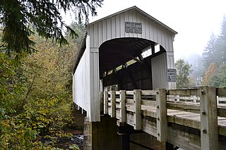
Wildcat Creek Bridge is a covered bridge built in 1925 at Austa, near Walton, in the U.S. state of Oregon. It uses Howe truss engineering and was listed on the National Register of Historic Places in 1979. The 75-foot (23 m) bridge carries Austa Road over Wildcat Creek near its confluence with the Siuslaw River.

Unity Bridge is an historic 90-foot (27 m) long covered bridge over Fall Creek at Unity near Lowell in Lane County, Oregon, United States. Also known as Unity Covered Bridge and Unity Creek Bridge, it was built in 1936 at a cost $4,400 by Lane County using the Howe truss system. Its east side features a full-length window with its own roof so that drivers can see oncoming cars.
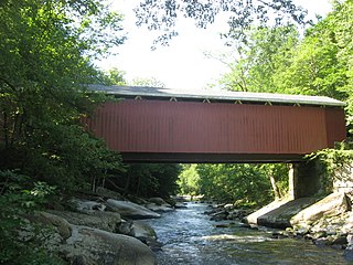
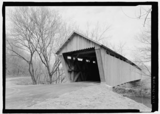
The McConnell's Mill Covered Bridge is a wooden covered bridge in Slippery Rock Township, Lawrence County, Pennsylvania, United States. It spans the Slippery Rock Creek in McConnells Mill State Park, southeast of Rose Point, Built in 1874, the bridge is a Howe truss built on stone foundations and supported by steel girders.

The Banks Covered Bridge is a wooden covered bridge in Wilmington Township, Lawrence County, Pennsylvania, United States. It spans the Neshannock Creek southeast of New Wilmington. Constructed in 1889, the bridge is a Burr arch truss built on stone foundations and supported by steel girders; it is 121 feet (37 m) long.

Lee's Creek Covered Bridge is a historic wooden bridge on Lee's Creek Road 0.1 miles (0.16 km) south of Kentucky Route 8 near Dover, Kentucky. It is 61 feet (19 m) long with a double set of Queen post trusses on each side.
The Valley Pike Covered Bridge was a historic covered bridge located in Mason County, Kentucky, United States. It crossed the Frasure Branch of Lee Creek. It was added to the National Register of Historic Places in 1976. The bridge was dismantled after flood damage on April 27, 2018.

Spanning 63 feet (19 m) the Goddard Bridge crosses the Sand Lick Creek just off Kentucky 32, about 8 miles south of Flemingsburg on Covered Bridge Road in Goddard, Kentucky. The Pea Ridge Mountains and an old country church provide a scenic backdrop.

The Hillsboro Covered Bridge, known locally as the "Hillsboro-Grange City Covered Bridge", spans Fox Creek in Fleming County adjacent to Kentucky Route 111, 13.6 miles (21.9 km) southeast of Flemingsburg, Kentucky. Probably built in the late 1860s, it was discontinued in 1968 when it was replaced fifty yards (46 m) upstream by a concrete bridge.

The Ringos Mill Covered Bridge spans Fox Creek in Fleming County, Kentucky in a single 90-foot span. It was named for a grist mill situated 50 yards downstream.

The Covered Bridge in Cedarburg, Ozaukee County, Wisconsin, United States, is one of the last remaining covered bridges in that state, which once had about 40 covered bridges. Built in 1876 to cross Cedar Creek, the bridge is 120 feet (37 m) long and is made of pine with oak lattices. It was listed on the National Register of Historic Places in 1973 and is now used only for pedestrian traffic.

The Christman Covered Bridge is a historic covered bridge that carries Eaton-New Hope Road over Seven Mile Creek in Washington Township, Preble County, Ohio, United States, northwest of the city of Eaton. It was built in 1895 by Everett S. Sherman, who built at least 20 covered bridges in Preble County. It was listed on the National Register of Historic Places in 1976.

The Depot Covered Bridge is a historic Town lattice truss bridge, carrying Depot Hill Road over Otter Creek in Pittsford, Vermont. The bridge was built about 1840, and is one of Vermont's older covered bridges. It underwent restoration in the 1980s, and was subsequently reinforced with steel stringers. It was listed on the National Register of Historic Places in 1974.
The Scottown Covered Bridge, near Scottown, Ohio, was built in 1874. It was listed on the National Register of Historic Places in 1975. It is a Multiple Kingpost covered bridge.
Bennett's Mill Covered Bridge, near Greenup, Kentucky, was built in 1855. It was listed on the National Register of Historic Places in 1976.

Oldtown Covered Bridge, near Oldtown, Kentucky, was listed on the National Register of Historic Places in 1976.

