
The King Iron Bridge & Manufacturing Company was a late-19th-century bridge building company located in Cleveland, Ohio. It was founded by Zenas King (1818–1892) in 1858 and subsequently managed by his sons, James A. King and Harry W. King and then his grandson, Norman C. King, until the mid-1920s. Many of the bridges built by the company were used during America's expansion west in the late 19th century and early 20th century, and some of these bridges are still standing today.

The Locust Creek Covered Bridge is the only remaining covered bridge in Pocahontas County, West Virginia. It is located approximately 6 miles (9.7 km) outside Hillsboro. The bridge is now for pedestrian traffic only.

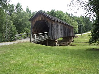
The Union Covered Bridge State Historic Site is a Missouri State Historic Site in Monroe County, Missouri. The covered bridge is a Burr-arch truss structure built in 1871 over the Elk Fork of the Salt River. It was almost lost to neglect in the 1960s, but was added to the state park system in 1967, the same year it was damaged by a flood. Repairs were made the next year, using timbers salvaged from another covered bridge that had been destroyed by the same flood. In 1970, it was closed to vehicular traffic and was added to the National Register of Historic Places. Further repairs were made in 1988, and it survived the Great Flood of 1993, only to be damaged by another flood in 2008 and later re-repaired. It is about 120 feet (37 m) or 125 feet (38 m) long, 12 feet (3.7 m) high, and 17.5 feet (5.3 m) wide.

The East Fairfield Covered Bridge is a covered bridge that carries Bridge Street across Black Creek in the East Fairfield village of Fairfield, Vermont. Built about 1865, it is the town's only surviving 19th century covered bridge. It was listed on the National Register of Historic Places in 1974.

Lee's Creek Covered Bridge is a historic wooden bridge on Lee's Creek Road 0.1 miles (0.16 km) south of Kentucky Route 8 near Dover, Kentucky. It is 61 feet (19 m) long with a double set of Queen post trusses on each side.
The Valley Pike Covered Bridge was a historic covered bridge located in Mason County, Kentucky, United States. It crossed the Frasure Branch of Lee Creek. It was added to the National Register of Historic Places in 1976. The bridge was dismantled after flood damage on April 27, 2018.

Spanning 63 feet (19 m) the Goddard Bridge crosses the Sand Lick Creek just off Kentucky 32, about 8 miles south of Flemingsburg on Covered Bridge Road in Goddard, Kentucky. The Pea Ridge Mountains and an old country church provide a scenic backdrop.

The Hillsboro Covered Bridge, known locally as the "Hillsboro-Grange City Covered Bridge", spans Fox Creek in Fleming County adjacent to Kentucky Route 111, 13.6 miles (21.9 km) southeast of Flemingsburg, Kentucky. Probably built in the late 1860s, it was discontinued in 1968 when it was replaced fifty yards (46 m) upstream by a concrete bridge.

The Ringos Mill Covered Bridge spans Fox Creek in Fleming County, Kentucky, in a single 90-foot span. It was named for a grist mill situated 50 yards downstream.

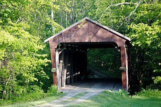
The Hammond Covered Bridge is a Town lattice covered bridge spanning Otter Creek in Pittsford, Vermont. The bridge was built in 1842 by Asa Norse, and originally carried Kendall Hill Road, which now passes just to its south. The bridge was added to the National Register of Historic Places on January 21, 1974.

Spanning 124 feet (38 m), the 18 feet (5.5 m) wide Colville Covered Bridge is located along the Colville Pike where it crosses Hinkston Creek about four miles northwest of Millersburg, Kentucky. The bridge is situated 28 feet (8.5 m) above the water level in a rural area where vehicular traffic mainly comprises local residents and farm vehicles.

Spanning 114 feet (35 m), the Cabin Creek Covered Bridge crosses Cabin Creek 4.5 miles (7.2 km) northwest of Tollesboro on Kentucky Highway 984 about 12.4 miles from the Lewis-Fleming County line. It is no longer open to vehicular traffic.

The Dingleton Hill Covered Bridge, also known as the Cornish Mills Bridge, is a historic wooden covered bridge, carrying Root Hill Road over Mill Brook in Cornish Mills, New Hampshire. Built in 1882, it is one of the state's few surviving 19th-century covered bridges. It was listed on the National Register of Historic Places in 1978. It carries one lane of traffic, with a posted weight limit.
The Kenyon Bridge, also known as the Blacksmith Shop Bridge, is a historic covered bridge spanning Mill Brook near Town House Road in Cornish, New Hampshire, United States. Built in 1882, it is one of New Hampshire's few surviving 19th-century covered bridges. It was listed on the National Register of Historic Places in 1978.

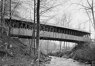
The Waterman Covered Bridge was an historic covered bridge in Johnson, Vermont that carried Waterman Road across Waterman Creek. Built in 1868, it was one of three surviving 19th-century bridges in the town. It was listed on the National Register of Historic Places in 1974, and collapsed in January 1982.

The Ten Mile Creek Bridge was a historic structure located northwest of Decorah, Iowa, United States. It spanned Ten Mile Creek for 36 feet (11 m). The R.D. Wheaton Bridge Company of Chicago supplied several king post truss bridges to Winneshiek County in the mid-1890s, and this is probably one of them. There are no county records specific to this bridge. It was listed on the National Register of Historic Places in 1998 and it was delisted in 2017.
The Yatesville Covered Bridge, in Lawrence County, Kentucky near Fallsburg, was built in 1907 and was listed on the National Register of Historic Places in 1976.
The Hizey Covered Bridge, in Fairfield County, Ohio, is a Burr Truss covered bridge which was built in 1891 by James W. Buchanan. It was listed on the National Register of Historic Places in 1976 when it was still located at its original location.
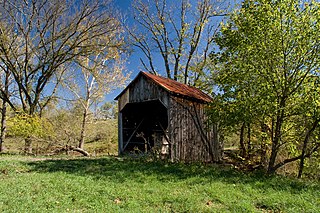
The Auchumpkee Creek Covered Bridge, near Thomaston, Georgia, was built in 1898. It was listed on the National Register of Historic Places in 1975.

The Five Mile Drive-Sutter Creek Bridge, in Amador County, California near Ione, California, is a Pony Pratt half-truss bridge built in 1910. It was listed on the United States National Register of Historic Places in 1986.


