
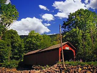
The Landis Mill Covered Bridge is a covered bridge that spans the Little Conestoga Creek in Lancaster County, Pennsylvania, United States. A county-owned and maintained bridge, its official designation is the Little Conestoga #1 Bridge. The bridge, built in 1873 by Elias McMellen, is today surrounded by a development, shopping center, and highways on the boundary of Lancaster, Pennsylvania. At 53 feet (16 m), it is the shortest covered bridge in the county.

The Stillwater Bridge is a vertical-lift bridge crossing the St. Croix River between Stillwater, Minnesota, and Houlton, Wisconsin. It formerly connected Minnesota State Highway 36 and Wisconsin Highway 64. Around 18,000 vehicles crossed the bridge daily. The new St. Croix Crossing bridge crossing the St. Croix river valley to the south of Stillwater replaced its purpose, having opened to highway traffic on August 2, 2017, leaving the Stillwater Lift Bridge to be preserved and to be converted to bicycle/pedestrian use.

The Bahia Honda Rail Bridge is a derelict railroad bridge in the lower Florida Keys connecting Bahia Honda Key with Spanish Harbor Key. It was originally part of the Overseas Railway, but the state of Florida purchased it from the Florida East Coast Railway (FEC) after the 1935 Labor Day Hurricane and converted it for automobile use as part of the Overseas Highway in 1938. After a replacement Bahia Honda Bridge was opened in 1972, two spans of the old bridge were removed for the safety of boat traffic and to prevent pedestrian access to unsafe parts of the bridge.

The Lamar Boulevard Bridge is a historic arch bridge carrying Texas State Highway Loop 343 over Lady Bird Lake in downtown Austin, Texas, United States. The bridge features six open-spandrel concrete arches spanning 659 feet (201 m) and carries tens of thousands of vehicles daily across the lake. Completed in 1942, the Lamar Boulevard Bridge was the second permanent bridge to cross the Colorado River, and one of the last Art Deco-style open-spandrel concrete arch bridges built in Texas. The bridge was named an Austin Landmark in 1993 and added to the National Register of Historic Places in 1994.

The Cogan House Covered Bridge is a Burr arch truss covered bridge over Larrys Creek in Cogan House Township, Lycoming County, in the U.S. state of Pennsylvania. It was built in 1877 and is 94 feet 2 inches (28.7 m) long. The bridge was placed on the National Register of Historic Places in 1980, and had a major restoration in 1998. The Cogan House bridge is named for the township and village of Cogan House, and is also known by at least four other names: Buckhorn, Larrys Creek, Day's, and Plankenhorn.
The Sonestown Covered Bridge is a covered bridge over Muncy Creek in Davidson Township, Sullivan County, Pennsylvania built around 1850. It is 110 ft (34 m) long and was placed on the National Register of Historic Places (NRHP) in 1980. It is named for the nearby unincorporated village of Sonestown in Davidson Township, and is also known as the Davidson Covered Bridge. It was built to provide access to a grist mill which operated until the early 20th century.

The Forksville Covered Bridge is a Burr arch truss covered bridge over Loyalsock Creek in the borough of Forksville, Sullivan County, in the U.S. state of Pennsylvania. It was built in 1850 and is 152 feet 11 inches (46.61 m) in length. The bridge was placed on the National Register of Historic Places in 1980. The Forksville bridge is named for the borough it is in, which in turn is named for its location at the confluence or "forks" of the Little Loyalsock and Loyalsock Creeks.

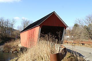
The Hillsgrove Covered Bridge is a Burr arch truss covered bridge over Loyalsock Creek in Hillsgrove Township, Sullivan County, in the U.S. state of Pennsylvania. It was built c. 1850 and is 186 feet (56.7 m) long. In 1973, it became the first covered bridge in the county to be placed on the National Register of Historic Places (NRHP). The bridge is named for the township and nearby unincorporated village of Hillsgrove, and is also known as Rinkers Covered Bridge for an adjoining farm.

The Goodpasture Bridge spans the McKenzie River near the community of Vida in Lane County, Oregon, United States. It is the second longest covered bridge and one of the most photographed covered bridges in the state. The Goodpasture Bridge is listed on the National Register of Historic Places.
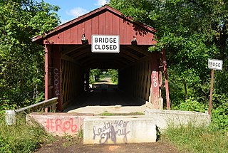
The Waterford Covered Bridge is a Town lattice truss covered bridge spanning LeBoeuf Creek in Waterford Township, Erie County in the U.S. state of Pennsylvania. The bridge was built in 1875, and is 85 feet 11 inches (26.2 m) in length. The Waterford Covered Bridge is one of two remaining covered bridges in Erie County, along with the Harrington Covered Bridge. The bridge is also the only Town lattice truss bridge in the county and one of only 19 in Pennsylvania. It was documented by the Historic American Buildings Survey in 1936 and was listed on the National Register of Historic Places in 1980. In 2011, the bridge was closed due to its deteriorating condition.
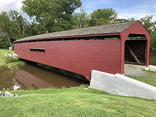
The Gilpin's Falls Covered Bridge is a Burr arch through truss wooden covered bridge in Bay View, Cecil County, Maryland, United States, close to the town of North East. The bridge was constructed by local Cecil County bridgewright Joseph George Johnson in the autumn and winter of 1860-61 across North East Creek. The bridge was erected adjacent to and upstream of Samuel Gilpin's mills and dam and crosses the millpond formed by it. This bridge has a span of 100 feet (30 m) and a total length of 119 feet (36 m) with its shelter panel overhangs, is 13.5 feet (4.1 m) wide, and is closed to all vehicular traffic.

The Kentucky Route 2014 Bridge along Kentucky Route 2014 in Bell County, Kentucky, was a truss bridge spanning the Cumberland River near Pineville, Kentucky. The bridge was 328 feet (100 m) long. The bridge was a Warren through truss bridge, and one of the early styles of the bridge. The bridge was constructed in 1873 by the Louisville Bridge and Iron Company of Louisville, Kentucky, and the Phoenix Iron Company of Pennsylvania and subsequently maintained by the Kentucky Transportation Cabinet. Its vertical clearance was 22 feet 6 inches (6.86 m) and could hold a limit of 15 tons of traffic.
The Gates Farm Covered Bridge is a covered bridge that crosses the Seymour River off State Route 15 in Cambridge, Vermont. Built in 1897, it is last bridge to be built during the historic period of covered bridge construction with the Burr arch design. It was listed on the National Register of Historic Places in 1974.

Watson Settlement Bridge was an historic covered bridge in eastern Littleton, Maine, United States. Built in 1911, it was one of the youngest of Maine's few surviving covered bridges. It formerly carried Framingham Road over the Meduxnekeag River, but was closed to traffic, the road passing over a modern bridge to its south. It was listed on the National Register of Historic Places in 1970. It was destroyed by fire on July 19, 2021.
The Gifford Covered Bridge, also called the C.K. Smith Covered Bridge, is a wooden covered bridge that crosses the Second Branch of the White River in Randolph, Vermont on Hyde Road. It was listed on the National Register of Historic Places in 1974. It is one of two bridges in the state that was uncovered when first built, its trusses boxed for shelter.

Spanning 63 feet (19 m) the Goddard Bridge crosses the Sand Lick Creek just off Kentucky 32, about 8 miles south of Flemingsburg on Covered Bridge Road in Goddard, Kentucky. The Pea Ridge Mountains and an old country church provide a scenic backdrop.

Spanning 124 feet (38 m), the 18 feet (5.5 m) wide Colville Covered Bridge is located along the Colville Pike where it crosses Hinkston Creek about four miles northwest of Millersburg, Kentucky. The bridge is situated 28 feet (8.5 m) above the water level in a rural area where vehicular traffic mainly comprises local residents and farm vehicles.

Spanning 114 feet (35 m), the Cabin Creek Covered Bridge crosses Cabin Creek 4.5 miles (7.2 km) northwest of Tollesboro on Kentucky Highway 984 about 12.4 miles from the Lewis-Fleming County line. It is no longer open to vehicular traffic.

The Robyville Bridge is a historic covered bridge in Corinth, Maine. Built in 1876, this Howe truss bridge is one of the state's few surviving 19th-century covered bridges. It carries Covered Bridge Road across Kenduskeag Stream in the southern part of the rural community. It was listed on the National Register of Historic Places in 1970 and designated as a Maine Historic Civil Engineering Landmark by the American Society of Civil Engineers in 2002.

The Gugel Bridge, also known as the Beyer Road – Cass River Bridge, is a bridge carrying Beyer Road over the Cass River in Frankenmuth Township, Michigan. It was listed on the National Register of Historic Places in 2000. It is the only remaining example in Michigan of a bridge with both a pony truss span and a main through truss span.


