
Brandywine Creek is a tributary of the Christina River in southeastern Pennsylvania and northern Delaware in the United States. The Lower Brandywine is 20.4 miles (32.8 km) long and is a designated Pennsylvania Scenic River with several tributary streams. The East Branch and West Branch of the creek originate within 2 miles (3 km) of each other on the slopes of Welsh Mountain in Honey Brook Township, Pennsylvania, about 20 miles (32 km) northwest of their confluence.
Red Clay Creek is a 12.7-mile-long (20.4 km) tributary of White Clay Creek, running through southeastern Pennsylvania and northern Delaware in the United States. As of 2000, portions of the creek are under wildlife habitat protection.

The Wilmington and Western Railroad is a freight and heritage railroad in northern Delaware, operating over a former Baltimore and Ohio Railroad (B&O) branch line between Wilmington and Hockessin. The 10.2-mile (16.4 km) railroad operates both steam and diesel locomotives. It was added to the National Register of Historic Places as a national historic district in 1980. Wilmington & Western serves one customer for revenue service, and interchanges with CSX Transportation at Landenberg Junction, Delaware

St. James Episcopal Church, Mill Creek, also known as St. James Church or St. James Church, Stanton, is an historic Episcopal church located at 2106 St. James Church Road, in Stanton, Mill Creek Hundred, New Castle County near Wilmington, Delaware.
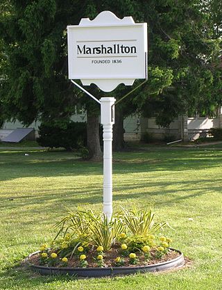
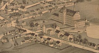
Marshallton is an unincorporated community in Mill Creek Hundred, New Castle County, Delaware, United States. The community was founded in 1836 and is named for John Marshall, mill owner.

Delaware Route 82 (DE 82) is a state highway in the northwest suburbs of Wilmington in New Castle County, Delaware. The route, which is signed north-south, runs 5.49 miles (8.84 km) from DE 52 near Greenville northwest to the Pennsylvania state line near Yorklyn, where the road continues into that state as Pennsylvania Route 82 (PA 82). The route runs through areas of woods and fields in northern New Castle County, with much of the route paralleling the Red Clay Creek. The entire route is a part of the Red Clay Scenic Byway, created in 2005. DE 82 was first numbered by 1952 on its current alignment. In 2010, the Delaware Department of Transportation (DelDOT) proposed eliminating the route number, but the plan fell through due to public opposition.

The Swann Covered Bridge, also called the Joy Covered Bridge or Swann-Joy Covered Bridge, is a county-owned, wood-and-metal combination style covered bridge that spans the Locust Fork of the Black Warrior River in Blount County, Alabama, United States. It is located on Swann Bridge Road off State Route 79, just west of the town of Cleveland, about 10 miles (16 km) northwest of Oneonta.

Green Sergeant's Covered Bridge is a wooden covered bridge over the Wickecheoke Creek near the border between the Hunterdon Plateau and Amwell Valley located in Delaware Township, Hunterdon County, New Jersey. As the last historic covered bridge in the state of New Jersey, it was listed on the National Register of Historic Places on November 19, 1974 for its significance in engineering and transportation. It was added as a contributing property to the Covered Bridge Historic District in 1999.
The Sonestown Covered Bridge is a covered bridge over Muncy Creek in Davidson Township, Sullivan County, Pennsylvania built around 1850. It is 110 ft (34 m) long and was placed on the National Register of Historic Places (NRHP) in 1980. It is named for the nearby unincorporated village of Sonestown in Davidson Township, and is also known as the Davidson Covered Bridge. It was built to provide access to a grist mill which operated until the early 20th century.
The Waterford Covered Bridge is a Town lattice truss covered bridge spanning LeBoeuf Creek in Waterford Township, Erie County in the U.S. state of Pennsylvania. The bridge was built in 1875, and is 85 feet 11 inches (26.2 m) in length. The Waterford Covered Bridge is one of two remaining covered bridges in Erie County, along with the Harrington Covered Bridge. The bridge is also the only Town lattice truss bridge in the county and one of only 19 in Pennsylvania. It was documented by the Historic American Buildings Survey in 1936 and was listed on the National Register of Historic Places in 1980. In 2011, the bridge was closed due to its deteriorating condition.
Plunketts Creek Bridge No. 3 was a rubble masonry stone arch bridge over Plunketts Creek in Plunketts Creek Township, Lycoming County in the U.S. state of Pennsylvania. It was built between 1840 and 1875, probably closer to 1840, when the road along the creek between the unincorporated villages of Barbours and Proctor was constructed. Going upstream from the mouth, the bridge was the third to cross the creek, hence its name.
Ashland is an unincorporated community in New Castle County, Delaware, United States. Ashland is located at the intersection of Delaware Route 82 and Barley Mill Road along the Red Clay Creek.
Wooddale is an unincorporated community in New Castle County, Delaware, United States. Wooddale is located along the Red Clay Creek and Rolling Mill Road, west of Wilmington.
The Ashland Mill Bridge was a lenticular pony truss bridge over the Pachaug River in Griswold, Connecticut that was built in 1886 by the Berlin Iron Bridge Company. It was built following the Ashland dam break of February 1886 which washed away the previous bridges. The bridge served the millyard of the Ashland Cotton Company, in the Jewett City section of Griswold. The bridge was 65 feet (20 m) long and crossed a millrace on a skew angle. The Ashland Mill was damaged by arson in March 1995 and subsequently torn down, but the bridge itself remained. By 1999, the town deemed the bridge unsafe and closed it, and by February 1999, the bridge was moved to a vacant parking lot and was replaced with a new bridge. The bridge was added to the state of Connecticut historic register and it was later added to the National Register of Historic Places in April 1999. It was removed from the National Register in February 2016.

The Whipple Cast and Wrought Iron Bowstring Truss Bridge, is located near the entrance to Stevens Farm in southwestern Albany, New York, United States. It was built in 1867, but not moved to its present location until 1899. It is one of the oldest surviving iron bridges in the county, one of the few that use both cast and wrought iron and one of only two surviving examples of the Whipple bowstring truss type. In 1971 it was listed on the National Register of Historic Places, the only bridge in the city of Albany so far to be listed individually.

The Pulp Mill Covered Bridge, also called the Paper Mill Covered Bridge, is a wooden covered bridge that crosses Otter Creek between Middlebury and Weybridge, Vermont on Seymour Street. It was listed on the National Register of Historic Places in 1974.

The Great Eddy Covered Bridge, also called the Big Eddy Covered Bridge or Waitsfield Covered Bridge, is a wooden covered bridge that crosses the Mad River in Waitsfield, Vermont on Bridge Street. Built in 1833, it is one of Vermont's oldest covered bridges. It was listed on the National Register of Historic Places in 1974.

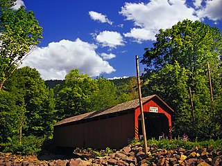
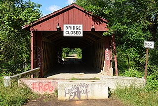
Wooddale Bridge is a covered bridge over Red Clay Creek at Wooddale in New Castle County, Delaware. It is one of three covered bridges in the state of Delaware along with the very similar Ashland Covered Bridge and the Smith Bridge. It and the Ashland bridge remain, of the thirteen bridges along the Red Clay Creek that were marked on an 1868 map.

The Taftsville Covered Bridge is a timber-framed covered bridge which spans the Ottauquechee River in the Taftsville village of Woodstock, Vermont, in the United States. Built in 1836 and exhibiting no influence from patented bridge designs, it is among the oldest remaining covered bridges both in Vermont and the nation as a whole.


