Tropical Storm Henri (2003)

Last updated

Map key
  Tropical depression (≤38 mph, ≤62 km/h)
  Tropical storm (39–73 mph, 63–118 km/h)
  Category 1 (74–95 mph, 119–153 km/h)
  Category 2 (96–110 mph, 154–177 km/h)
  Category 3 (111–129 mph, 178–208 km/h)
  Category 4 (130–156 mph, 209–251 km/h)
  Category 5 (≥157 mph, ≥252 km/h)
  Unknown
Storm type
Disc Plain black.svg Tropical cyclone
Solid black.svg Subtropical cyclone
ArrowUp.svg Extratropical cyclone, remnant low, tropical disturbance, or monsoon depression

On August 22, a tropical wave moved off the coast of Africa, and it moved westward across the Atlantic Ocean and Caribbean Sea without developing significantly. On September 1 the wave axis entered the Gulf of Mexico, and upon doing so convection steadily organized around a low-level center of circulation. The system moved northward and developed into Tropical Depression Twelve on September 3 while located about 300  miles (480  kilometers) west of Tampa, Florida. Embedded within a slow mid-latitude trough, the depression moved eastward and strengthened into Tropical Storm Henri on September 5. [1]

Remnants of Henri near North Carolina on September 12 Henri Remnants (2003).JPG
Remnants of Henri near North Carolina on September 12

Despite strong southwesterly vertical shear, Henri continued intensifying while moving eastward, and reached a peak strength of 60 mph (97 km/h) later on September 5. Shortly thereafter, though, the shear greatly weakened the storm, and it was downgraded to a tropical depression. Henri was not able to recover its intensity, and made landfall near Clearwater, Florida on September 6 as a 35 mph (56 km/h) tropical depression, and quickly crossed the state as it accelerated to the northeast. [1] Despite initial predictions of re-intensification over open waters due to potentially lower shear, [2] Henri failed to re-strengthen and degenerated into a remnant low pressure area on September 8 off the coast of North Carolina. [1]

The broad and disorganized remnant low remained nearly stationary due to a ridge of high pressure to its north. [1] Residual convection within the remnants of Henri remained disorganized, but forecasters kept watch for the potential for redevelopment. [3] However, it moved inland near Cape Hatteras on September 12 without reorganizing. [4] The remnants continued to the north and dissipated on September 17 over New England. [5]

Preparations

The National Hurricane Center issued a Tropical Storm Warning from Englewood to Indian Pass, Florida while Henri was a tropical depression; however, warnings were discontinued by the time Henri made landfall. [1] Flood warnings were issued across the state prior to the storm making landfall, with predictions of 5 to 10 inches (127 to 254 millimetres) of rainfall. [6] As a result of the storm's approach, twelve shelters were placed on standby. Similarly, the Hurricane Shelter Information Hotline was placed on standby and ready to be activated within 10 minutes. [7] Levy County officials declared a state of emergency. There, sand bags and sand were sent to Cedar Key, Yankeetown, and Inglis in anticipation for storm surge and flooding. [8]

Impact

Rainfall from Henri Henri 2003 rainfall.gif
Rainfall from Henri

Henri dropped heavy rainfall along its path, with the worst of the flooding occurring in Delaware. The storm caused $19.6 million in damage (2003 USD), primarily in Delaware.[ citation needed ]

Florida, Bahamas, and Bermuda

Before making landfall, the storm produced strong waves on the Florida west coast. [6] Following a summer of tropical moisture in Florida, Henri brought more heavy rainfall to the saturated state, [9] peaking at 9.09 in (231 mm) in Hialeah in the southeast portion of the state. Two other areas experienced over 7 in (180 mm), though most areas received only light rainfall. [5] In Hernando County, a stationary thunderstorm dropped over 5 in (130 mm) of rain in around an hour. It caused a rapid flooding of roads, though quickly retreated. Damage was minor, due to lack of many homes in the area. [10] A feeder band in Charlotte County dropped 7 in (180 mm) of rain in three hours, flooding numerous streets and homes. [11] Throughout Florida, damage was minimal, and there were no deaths. However, lightning from a feeder band injured a man in Lee County, while an indirect injury occurred from a car crash due to hydroplaning. [1]

In the Bahamas, outer rainbands from Henri dropped around 1 inch (25 mm) of rain. Winds in the archipelago gusted to 32 mph (51 km/h). [12] Just days after Hurricane Fabian struck Bermuda, moisture from Henri brought thunderstorms and heavy rainfall and thunderstorms totaling to 2.44 inches (62 mm) at the airport. [13] This hindered cleanup efforts, though caused no known damage. [14]

Mid-Atlantic

In North Carolina, Virginia, and Maryland, rainfall was generally light, with the exception of a few areas receiving over 3 inches (76 mm). [5] Henri produced greater amounts of rain in Delaware and Pennsylvania, with a peak of 9.02 in (229 mm) in Hockessin. [15] In Downingtown, Pennsylvania, over eight inches (203 mm) of rain fell in around six hours, while Doppler Radar estimated that Kennett Square received over 10 inches (250 mm) in a five-hour period. The heavy rainfall led to record discharge rates along the Red Clay Creek, which also had a record crest peaking at just below 26 feet (7.9 m). Parts of the creek saw a 500-year flood, which has a 0.2% chance of occurring in any given year. [16] Numerous rivers in southeastern Pennsylvania also crested above their flood stage. [17]

A destroyed Glenville, Delaware home on October 2, 2003, two weeks after Tropical Storm Henri flooded the subdivision Abandoned house in Glenville Delaware.jpg
A destroyed Glenville, Delaware home on October 2, 2003, two weeks after Tropical Storm Henri flooded the subdivision

In Delaware, the flooding damaged numerous houses, including 194 in the Glenville area. The rapid flooding trapped numerous people in their cars and homes, forcing at least one rescue by helicopter. Those people were evacuated to nearby schools. The severe flooding washed out most of a bridge in Hockessin [15] and destroyed 6 Wilmington & Western Railroad bridges, [18] causing about $5 million (2003 USD, $5.5 million 2006 USD) in damage. [19] The railroad bridges were still being rebuilt as of 2006. [20] Greenbank Mill, a historic gristmill complex, saw $450,000 in damage. [21] Damage in Delaware totaled to $16.1 million (2003  USD, $17.5 million 2006 USD). [15]

Flash flooding in Pennsylvania resulted in 2,600 emergency 911 calls and around 100 rescues for cars or houses. The flooding destroyed 12 homes, and damaged 336, over half of them severely. Wet soil downed trees and power lines, causing power outages to 109,000  PECO Energy customers. High floodwaters damaged 22 bridges and closed 2 indefinitely, [17] while the flooding closed several roads, including a portion of U.S. Route 1 in Chadds Ford. [22] Damage in Pennsylvania totaled to $3.5 million (2003 USD, $3.8 million 2006 USD). [17] The impacts were severely compounded the following week by Hurricane Isabel across the region.[ citation needed ]

Aftermath

On September 23, just days after the storm moved through, President George W. Bush declared New Castle County, Delaware as a disaster area following the effects of Henri and later Hurricane Isabel. The declaration designated the affected citizens eligible for grants to pay for temporary housing, house repairs, and serious disaster-related expenses. The declaration also allowed for federal funding for 75% of the repair cost for replacing public facilities. [23] By two months after the storm, 659 residents had applied for disaster aid through the Federal Emergency Management Agency (FEMA), totaling to just over $1 million (2003 USD, $1.1 million 2006 USD). 141 small businesses applied for loans, totaling to around $2.5 million (2003 USD, $2.75 million 2006 USD). In addition, FEMA received 183 applications for public assistance, which would be used for rebuilding public roads and buildings. [24] Over twenty volunteer organizations met to establish a long-term committee to find resources for disaster recovery needs. One goal sought by the committee was to find a permanent housing solution for every one who was displaced from their houses from the storms. Volunteers also helped remove ruined appliances and furniture to local landfills, totaling to more than 300 tons. [25] State and county governments in Delaware purchased 171 homes following the damage in the Glenville area, the highest number of houses purchased in the state due to storm damage. [26] The house purchasing was done to mitigate the flood damage by restoring the area as a wetland. [27]

On September 26, President Bush also declared Chester County, Pennsylvania as a disaster area following the damage of Henri, Tropical Storm Isabel, and severe flooding unrelated to either tropical cyclone. [28] By a month after the declaration, 342 homeowners and business owners applied for disaster aid, totaling to around $600,000 (2003 USD, $660,000 2006 USD). [29]

See also

Related Research Articles

<span class="mw-page-title-main">Hurricane Isabel</span> Category 5 Atlantic hurricane in 2003

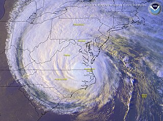
Hurricane Isabel was the strongest Atlantic hurricane since Mitch, and the deadliest, costliest, and most intense hurricane in the 2003 Atlantic hurricane season. Hurricane Isabel was also the strongest hurricane in the open waters of the Atlantic, both by wind speed and central pressure, before being surpassed by hurricanes Irma and Dorian in 2017 and 2019, respectively. The ninth named storm, fifth hurricane, and second major hurricane of the season, Isabel formed near the Cape Verde Islands from a tropical wave on September 6, in the tropical Atlantic Ocean. It moved northwestward, and within an environment of light wind shear and warm waters, it steadily strengthened to reach peak winds of 165 mph (266 km/h) on September 11. After fluctuating in intensity for four days, during which it displayed annular characteristics, Isabel gradually weakened and made landfall on the Outer Banks of North Carolina, with winds of 105 mph (169 km/h) on September 18. Isabel quickly weakened over land and became extratropical over western Pennsylvania on the next day. On September 20, the extratropical remnants of Isabel were absorbed into another system over Eastern Canada.

<span class="mw-page-title-main">Tropical Storm Allison</span> Atlantic tropical storm in 2001

Tropical Storm Allison was a tropical storm that devastated southeast Texas in June of the 2001 Atlantic hurricane season. An arguable example of the "brown ocean effect", Allison lasted unusually long for a June storm, remaining tropical or subtropical for 16 days, most of which was when the storm was over land dumping torrential rainfall. The storm developed from a tropical wave in the northern Gulf of Mexico on June 4, 2001, and struck the upper Texas coast shortly thereafter. It drifted northward through the state, turned back to the south, and re-entered the Gulf of Mexico. The storm continued to the east-northeast, made landfall on Louisiana, then moved across the southeast United States and Mid-Atlantic. Allison was the first storm since Tropical Storm Frances in 1998 to strike the northern Texas coastline.

<span class="mw-page-title-main">Hurricane Agnes</span> Category 1 Atlantic hurricane in 1972

Hurricane Agnes was the costliest hurricane to hit the United States at the time, causing an estimated $2.1 billion in damage. The hurricane's death toll was 128. The effects of Agnes were widespread, from the Caribbean to Canada, with much of the east coast of the United States affected. Damage was heaviest in Pennsylvania, where Agnes was the state's wettest tropical cyclone. Due to the significant effects, the name Agnes was retired in the spring of 1973.

<span class="mw-page-title-main">2003 Atlantic hurricane season</span> Hurricane season in the Atlantic Ocean

The 2003 Atlantic hurricane season was a highly active Atlantic hurricane season with tropical activity before and after the official bounds of the season—the first such occurrence since the 1970 season. The season produced 21 tropical cyclones, of which 16 developed into named storms; seven of those attained hurricane status, of which three reached major hurricane status. With sixteen storms, the season was tied for the fifth-most active Atlantic hurricane season on record, although it has since dropped down to become the seventh most active season. The strongest hurricane of the season was Hurricane Isabel, which reached Category 5 status on the Saffir–Simpson hurricane scale northeast of the Lesser Antilles; Isabel later struck North Carolina as a Category 2 hurricane, causing $3.6 billion in damage and a total of 51 deaths across the Mid-Atlantic region of the United States.

<span class="mw-page-title-main">Tropical Storm Bonnie (2004)</span> Atlantic tropical cyclone

Tropical Storm Bonnie was a tropical storm that made landfall on Florida in August 2004. The second storm of the 2004 Atlantic hurricane season, Bonnie developed from a tropical wave on August 3 to the east of the Lesser Antilles. After moving through the islands, its fast forward motion caused it to dissipate. However, Bonnie later regenerated into a tropical storm near the Yucatán Peninsula. Bonnie attained its peak intensity with maximum 1-minute sustained winds of 65 miles per hour (105 km/h) and a minimum central pressure of 1,001 mbar on August 11 while located over the Gulf of Mexico. Afterwards, the storm turned to the northeast and hit Florida with winds of 45 miles per hour (72 km/h). The storm accelerated to the northeast and became an extratropical cyclone to the east of New Jersey. Bonnie was the first of five tropical systems in the 2004 season to make landfall in Florida, coming ashore the day before Hurricane Charley struck. Bonnie was also the second of a record eight storms to reach tropical storm strength during the month of August.

<span class="mw-page-title-main">Hurricane Jeanne</span> Category 3 Atlantic hurricane in 2004

Hurricane Jeanne was a Category 3 hurricane that struck the Caribbean and the Eastern United States in September 2004. It was the deadliest hurricane in the Atlantic basin since Mitch in 1998. It was the tenth named storm, the seventh hurricane, and the fifth major hurricane of the season, as well as the third hurricane and fourth named storm of the season to make landfall in Florida. After wreaking havoc on Hispaniola, Jeanne struggled to reorganize, eventually strengthening and performing a complete loop over the open Atlantic. It headed westwards, strengthening into a Category 3 hurricane and passing over the islands of Great Abaco and Grand Bahama in the Bahamas on September 25. Jeanne made landfall later in the day in Florida just two miles from where Hurricane Frances had struck a mere three weeks earlier.

<span class="mw-page-title-main">Hurricane Claudette (2003)</span> Category 1 Atlantic hurricane

Hurricane Claudette was a moderately strong tropical cyclone that struck South Texas in July 2003. A fairly long-lived July Atlantic hurricane, Claudette was the fourth depression, third tropical storm and first hurricane of the 2003 Atlantic hurricane season. Claudette began as a tropical wave in the eastern Caribbean. It moved quickly westward, brushing past the Yucatán Peninsula before moving northwestward through the Gulf of Mexico. Claudette remained a tropical storm until just before making landfall in Port O'Connor, Texas, when it quickly strengthened to a strong Category 1 hurricane on the Saffir-Simpson Hurricane Scale. Forecasting of its path and intensity was uncertain throughout its lifetime, resulting in widespread and often unnecessary preparations along its path.

<span class="mw-page-title-main">Tropical Storm Fay (2002)</span> Atlantic tropical storm in 2002

Tropical Storm Fay was the sixth named storm of the 2002 Atlantic hurricane season; it was a moderate tropical storm which caused flooding in parts of Texas and Northern Mexico. It formed from a trough of low pressure that moved south into the Gulf of Mexico, and became stationary. A low pressure center developed along this trough, and on September 5, a Hurricane Hunter aircraft reported that the system had gained sufficient organization to be classified a tropical depression, 95 miles (153 km) southeast of Galveston. The depression drifted south-southwest while strengthening, reaching its peak strength of 60 miles per hour (97 km/h) on the morning of September 6. The system then made an abrupt turn to the west-northwest, and remained steady in strength and course until landfall the next day, near Matagorda. The system weakened rapidly after landfall degenerating into a remnant low on September 8, but the storm's circulation survived for another three days.

<span class="mw-page-title-main">Hurricane Ernesto (2006)</span> Category 1 Atlantic hurricane in 2006

Hurricane Ernesto was the costliest tropical cyclone of the 2006 Atlantic hurricane season. The sixth tropical storm and first hurricane of the season, Ernesto developed from a tropical wave on August 24 in the eastern Caribbean Sea. Ernesto first affected the northern Caribbean, reaching minimal hurricane status near Haiti before weakening and moving across eastern Cuba as a tropical storm. Despite initial predictions for it to track through the eastern Gulf of Mexico as a major hurricane, Ernesto moved across eastern Florida as a weak tropical storm. After turning to the northeast, it re-intensified and made landfall on August 31 on the North Carolina coast just below hurricane status. Late the next day, Ernesto became extratropical after entering southern Virginia. The remnants spread moisture across the northeastern United States before dissipating over eastern Canada on September 4.

<span class="mw-page-title-main">Tropical Storm Doria</span> Atlantic tropical storm in 1971

Tropical Storm Doria was the costliest tropical cyclone in the 1971 Atlantic hurricane season. The fifth tropical storm of the season, Doria developed from a tropical wave on August 20 to the east of the Lesser Antilles, and after five days without development it attained tropical storm status to the east of Florida. Doria turned to the north, and reached peak winds of 65 mph (105 km/h) as it was making landfall near Morehead City, North Carolina. It turned to the northeast, and moved through the Mid-Atlantic and New England as a tropical storm before becoming an extratropical storm over Maine on August 29.

<span class="mw-page-title-main">Effects of Hurricane Isabel in Delaware</span>

The effects of Hurricane Isabel in Delaware resulted in one of only thirteen presidential disaster declarations for the state of Delaware. Hurricane Isabel formed from a tropical wave on September 6, 2003, in the tropical Atlantic Ocean. It moved northwestward, and within an environment of light wind shear and warm waters, it steadily strengthened to reach peak winds of 165 mph (266 km/h) on September 11. After fluctuating in intensity for four days, Isabel gradually weakened and made landfall on the Outer Banks of North Carolina with winds of 105 mph (169 km/h) on September 18. It quickly weakened over land and became extratropical over Pennsylvania the next day. The storm's center remained to the south and west of Delaware, and was about 175 miles (282 km) from the state at its closest approach. At that time, Isabel was a strong tropical storm located in central Virginia.

<span class="mw-page-title-main">Effects of Hurricane Isabel in Pennsylvania</span>

The effects of Hurricane Isabel in Pennsylvania were primarily related to tropical storm force winds across much of the state. Hurricane Isabel formed from a tropical wave on September 6, 2003, in the tropical Atlantic Ocean. It moved northwestward, and within an environment of light wind shear and warm waters it steadily strengthened to reach peak winds of 165 mph (266 km/h) on September 11. After fluctuating in intensity for four days, Isabel gradually weakened and made landfall on the Outer Banks of North Carolina with winds of 105 mph (169 km/h) on September 18. It quickly weakened over land and became extratropical over western Pennsylvania the next day.

<span class="mw-page-title-main">Effects of Hurricane Isabel in Virginia</span>

The effects of Hurricane Isabel in Virginia proved to be the costliest disaster in the history of Virginia. Hurricane Isabel formed from a tropical wave on September 6, 2003, in the tropical Atlantic Ocean. It moved northwestward, and within an environment of light wind shear and warm waters it steadily strengthened to reach peak winds of 265 km/h (165 mph) on September 11. After fluctuating in intensity for four days, Isabel gradually weakened and made landfall on the Outer Banks of North Carolina with winds of 165 km/h (103 mph) on September 18. It quickly weakened over land as it passed through central Virginia, and Isabel became extratropical over western Pennsylvania on September 19.

<span class="mw-page-title-main">Effects of Hurricane Dennis in Florida</span>

The effects of Hurricane Dennis in Florida included 14 deaths and $1.5 billion in damage. The tropical wave that became Hurricane Dennis formed on June 29, 2005, and proceeded westward across the Atlantic Ocean. It became a tropical depression on July 4, a tropical storm on July 5, and a hurricane on July 7. Dennis rapidly intensified to attain Category 4 status on the Saffir-Simpson Hurricane Scale, and made landfall in Cuba where it weakened to Category 1 status, before re-emerging in the Gulf of Mexico and re–intensifying. The storm made landfall as a Category 3 hurricane on Santa Rosa Island on July 10.

<span class="mw-page-title-main">Effects of Tropical Storm Allison in Texas</span> Aftermath of tropical storm in texas

The effects of Tropical Storm Allison in Texas included 23 deaths caused by extreme flooding. The first storm of the 2001 Atlantic hurricane season, Tropical Storm Allison lasted unusually long for a June storm, remaining tropical or subtropical for 15 days. The storm developed from a tropical wave in the northern Gulf of Mexico on June 4, and struck the Texas coast shortly thereafter. It drifted northward through the state, turned back to the south, and re-entered the Gulf of Mexico. The storm continued to the east-northeast, made landfall on Louisiana, then moved across the southeast United States and Mid-Atlantic. Allison was the first storm since Tropical Storm Frances in 1998 to strike the northern Texas coastline.

<span class="mw-page-title-main">Effects of Hurricane Katrina in Florida</span>

The effects of Hurricane Katrina in Florida were in both the southern portion of the state and in the panhandle. After developing on August 23, Katrina made landfall near the border of Broward and Miami-Dade counties with 80 mph (130 km/h) winds on August 25. While it was crossing the state, the hurricane's convection was asymmetrical, primarily located to the south and east of the center. As a result, high rainfall totals occurred in the Miami area, peaking at 16.43 in (417 mm) in Perrine. The rains caused flooding, and the combination of rains and winds downed trees and power lines, leaving 1.45 million people without power. Damage in South Florida was estimated at $523 million (2005 USD), mostly as a result of crop damage. Further south, the hurricane spawned a tornado in the Florida Keys. In the island chain, Katrina caused heavy rainfall and gusty winds.

<span class="mw-page-title-main">Effects of Hurricane Jeanne in the Mid-Atlantic region</span>

The effects of Hurricane Jeanne in the Mid-Atlantic region of the United States included two fatalities and $530 million in damage. Originating from a tropical wave off the coast of Africa in early September 2004, Hurricane Jeanne tracked through the Leeward Islands and Hispaniola for several days, resulting in extensive damage and an immense loss of life. After completing a clockwise loop between September 22 and 24, the storm intensified into a major hurricane before striking the Bahamas and Florida. Substantially weaker, the system turned northeastward over Georgia before affecting Delaware, District of Columbia, Maryland, New Jersey, New York, Pennsylvania, Virginia, and West Virginia; all of those states are in the Mid-Atlantic region of the United States. By the evening of September 26, the Hydrometeorological Prediction Center took over responsibility of monitoring the former hurricane over Virginia.

References

  1. 1 2 3 4 5 6 Daniel P. Brown and Miles Lawrence (2003). "Tropical Storm Henri Tropical Cyclone Report" (PDF). National Hurricane Center . Retrieved May 22, 2015.
  2. James L. Franklin (2003). "Tropical Depression Henri Discussion 13". National Hurricane Center. Retrieved June 12, 2006.
  3. James L. Franklin (September 11, 2003). "Tropical Weather Outlook". National Hurricane Center. Retrieved August 16, 2018.
  4. James L. Franklin (September 12, 2003). "Tropical Weather Outlook". National Hurricane Center. Retrieved August 16, 2018.
  5. 1 2 3 David Roth (2006). "Rainfall information on Tropical Storm Henri". Hydrometeorological Prediction Center . Retrieved June 12, 2006.
  6. 1 2 GoFlorida (2003). "Tropical Storm Henri". Archived from the original on May 15, 2013. Retrieved June 12, 2006.
  7. Capital Area Chapter of the American Red Cross (2003). "Situation Report" (PDF). Archived from the original (PDF) on June 26, 2006. Retrieved June 12, 2006.
  8. Florida State Emergency Response Team (2001). "Situation Report" (PDF). Archived from the original (PDF) on June 26, 2006. Retrieved June 12, 2006.
  9. State of Florida Department of Community Affairs (2003). "2003 Hurricane Season Summary" (PDF). Archived from the original (PDF) on December 8, 2006. Retrieved June 12, 2006.
  10. National Climatic Data Center (2003). "Event Report for Florida". Archived from the original on February 4, 2012. Retrieved June 12, 2006.
  11. National Climatic Data Center (2003). "Event Report for Florida (2)". Archived from the original on February 4, 2012. Retrieved June 12, 2006.
  12. Stormcarib.com (2003). "Unofficial Reports from the Bahamas" . Retrieved June 12, 2006.
  13. Bermuda Weather Service (2003). "Weather Summary for September 2003". Archived from the original on February 5, 2012. Retrieved October 17, 2006.
  14. World Meteorological Organization RA IV Hurricane Committee (2004). "Final Report of the Twenty-Sixth Session" (PDF). Retrieved December 18, 2011.
  15. 1 2 3 National Climatic Data Center (2003). "Event Report for Delaware". Archived from the original on May 19, 2011. Retrieved June 12, 2006.
  16. Stefanie Baxter (2003). "Henri Visits Delaware" (PDF). Delaware Geological Survey. Archived from the original (PDF) on September 28, 2011. Retrieved June 12, 2006.
  17. 1 2 3 National Climatic Data Center (2003). "Event Report for Pennsylvania". Archived from the original on February 4, 2012. Retrieved June 12, 2006.
  18. Wilmington & Western Railroad (2006). "Rebuilding after Henri". Archived from the original on July 18, 2011. Retrieved June 12, 2006.
  19. Gary Gallaher (2003). "Isabel, Henri, and Grace: Three Names to Remember". Atlantic Coast Observer Network. Archived from the original on February 4, 2012. Retrieved June 12, 2006.
  20. Wilmington & Western Railroad (2006). "Rebuilding: The Latest". Archived from the original on June 23, 2006. Retrieved June 12, 2006.
  21. Tony Shahan (2003). "Red Clay Creek Flood, 9/15/03". Archived from the original on May 15, 2013. Retrieved June 15, 2006.
  22. National Climatic Data Center (2003). "Event Report for Pennsylvania". Archived from the original on February 4, 2012. Retrieved June 12, 2006.
  23. Federal Emergency Management Agency (2003). "Federal Disaster Funds Authorized To Aid Delaware Recovery From Tropical Storm Henri". Archived from the original on February 5, 2012. Retrieved June 13, 2006.
  24. FEMA (2003). "Disaster Victims Receive Over $3.5 Million In Assistance So Far". Archived from the original on October 3, 2006. Retrieved June 13, 2006.
  25. FEMA (2003). "Community Momentum Builds To Help Storm Victims". Archived from the original on October 3, 2006. Retrieved June 13, 2006.
  26. New Castle County Emergency Management (2006). "Hurricanes". Archived from the original on June 27, 2006. Retrieved June 12, 2006.
  27. Gerald J. Kauffman (2003). "Henri Visits Delaware: September 15, 2003 Tropical Storm Floods in Red Clay Creek Watershed". Delaware Water Resources Center. Archived from the original on September 28, 2011. Retrieved June 12, 2006.
  28. FEMA (2003). "Federal Disaster Aid Ordered For Pennsylvania Storms". Archived from the original on September 29, 2006. Retrieved June 13, 2006.
  29. FEMA (2003). "Disaster Aid Surpasses Half Million Dollars". Archived from the original on October 3, 2006. Retrieved June 13, 2006.
Tropical Storm Henri
Henri 2003-09-05 1630Z.jpg
Tropical Storm Henri near peak intensity on September 5