Related Research Articles

The State of Mexico, officially only Mexico, is one of the 32 federal entities of the United Mexican States. It is the most populous, as well as the most densely populated state. It is divided into 125 municipalities and its capital city is Toluca de Lerdo.

Iztacalco is one of the 16 boroughs of Mexico City. It is located in the central-eastern area and it is the smallest of the city's boroughs. The area's history began in 1309 when the island of Iztacalco, in what was Lake Texcoco, was settled in 1309 by the Mexica who would later found Tenochtitlan, according to the Codex Xolotl. The island community would remain small and isolated through the colonial period, but drainage projects in the Valley of Mexico dried up the lake around it. The area was transformed into a maze of small communities, artificial islands called chinampas and solid farmland divided by canals up until the first half of the 20th century. Politically, the area has been reorganized several times, being first incorporated in 1862 and the modern borough coming into existence in 1929. Today, all of the canals and farmland are dried out and urbanized as the most densely populated borough and the second most industrialized.

Iztapalapa is one of Mexico City’s 16 municipalities, located on the east side of the entity. The borough is named after and centered on the formerly independent municipality of Iztapalapa, which is officially called Iztapalapa de Cuitláhuac for disambiguation purposes. The rest is made up of a number of other communities which are governed by the city of Iztapalapa.

Xochimilco is one of the 16 mayoralities or boroughs within Mexico City. The borough is centered on the formerly independent city of Xochimilco, which was established on what was the southern shore of Lake Xochimilco in the precolonial period.

Tláhuac is one of the 16 boroughs into which Mexico City is divided. It is located on the south east edge of the district and while much is still rural in character, it has been undergoing urbanization with the fastest rate of population growth in Mexico City since the 1960s. Most of this urbanization is occurring in the northwest of the borough and in some of the larger communities, with the south and east still having significant tracts of farmland, which are under conservation. Much of the area is former lakebed where Lake Chalco and Lake Xochimilco met, with the town of San Pedro Tláhuac originally on an island. There are still some lake areas along with four major canals and wetlands, also under conservation status. The urbanization has led to serious traffic and transportation problems as well as the completion of Line 12 of the Mexico City Metro in 2012, which a terminal in the borough.

La Magdalena Contreras is one of the 16 administrative boroughs of the Federal District of Mexico City. As of the 2010 census, it has a population of 239,086 inhabitants and is the third-least populous of Mexico City's boroughs. It lies at an elevation of 2,365 m (7,759 ft) above sea level. It is named after two historically important communities—La Magdalena Atlitic and Colonia Contreras. The northern end of the borough is urbanized. The rest of Magdalena Contreras, with its mountains and ravines, is designated as a conservation zone. However, urban sprawl has put pressure on these conservation areas. In an effort to preserve the area's forests and natural resources, the borough government has started promoting ecotourism. The largest ecotourism park is Los Dinamos where canyons and ravines are cut by streams and freshwater springs that eventually form the Río Magdalena, Mexico City’s only remaining free-flowing river.

La Paz is a municipality in the State of Mexico, Mexico, with its [[Municipal seat|municipal seat as the town of Los Reyes Acaquilpan. It is located on the dividing line between Mexico State and the eastern edge of the Federal District and is part of the Greater Mexico City area. The area was part of a region called "Atlicpac" which in Náhuatl means 'above or at the edge of water.' The current city's/municipality's glyph symbolizes water.

The Valley of Mexico is a highlands plateau in central Mexico roughly coterminous with present-day Mexico City and the eastern half of the State of Mexico. Surrounded by mountains and volcanoes, the Valley of Mexico was a centre for several pre-Columbian civilizations, including Teotihuacan, the Toltec, and the Aztec. The ancient Aztec term Anahuac and the phrase Basin of Mexico are both used at times to refer to the Valley of Mexico. The Basin of Mexico became a well known site that epitomized the scene of early Classic Mesoamerican cultural development as well.

Lake Xochimilco is an ancient endorheic lake, located in the present-day Borough of Xochimilco in southern Mexico City.
San Andres Míxquic is a community located in the southeast of the Distrito Federal in the borough of Tláhuac. The community was founded by the 11th century on what was a small island in Lake Chalco. “Míxquic” means “in mesquite” but the community's culture for most of its history was based on chinampas, gardens floating on the lake's waters and tied to the island. Drainage of Lake Chalco in the 19th and 20th century eventually destroyed the chinampas but the community is still agricultural in nature, despite being officially in the territory of Mexico City.

Cuautitlán municipality in the State of Mexico, just north of the northern tip of the Federal District within the Greater Mexico City urban area. The city of Cuautitlán is the municipal seat and makes up most of the municipality. The name comes from Nahuatl and means 'between the trees.'
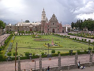
Chalco de Díaz Covarrubias is a city that is municipal seat of the surrounding municipality of Chalco. It lies in the eastern part of the State of Mexico just east of the Federal District of Mexico and is considered part of the Mexico City metropolitan area.

San Pedro Pochutla is a city and municipality located in the south of Oaxaca state, Mexico next to the Pacific Ocean. It is an important commercial, transportation and administrative hub for the Pochutla District in the east of the Costa Region. Pochutla is located at the junction of coastal Highway 200 and Highway 175 to Oaxaca, with 175 functioning as the town's main thoroughfare. Its name means "place of kapok trees ", and most of the city is built on a lakebed which was drained during the colonial period. The municipality is best known as being the home of the oceanside communities of Puerto Ángel and Zipolite.
Ixtapaluca is a city and a municipality in the eastern part of the State of Mexico in Mexico. It lies between the Federal District and the western border of the state of Puebla. The name Ixtapaluca means "Where the salt gets wet".

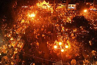
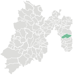
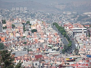
Valle de Chalco, officially named Valle de Chalco Solidaridad, is a municipality located in the State of Mexico, Mexico, on the eastern outskirts of the metropolitan area of Mexico City. Formerly part of the municipality of Chalco, it was split off as a separate entity in 1994, during the presidency of Salinas de Gortari, under his Programa Nacional de Solidaridad. The municipality lies on the old bed of Lake Chalco, which was substantially drained in the nineteenth century. Technically, the municipal seat is Xico, after a high point of land that once formed an island, and now remains as a small hill within an otherwise monotonous, urban expanse. "Chalco" refers to the Chalca tribe, whose territory covered the area around the lake, prior to the Spanish Conquest of Mexico.
Chalco may refer to:
Tultitlán de Mariano Escobedo is the fourth largest town in and municipal seat of the municipality of Tultitlán located in the northeastern part of the State of México in Mexico. It lies adjacent to the northern tip of the Federal District and is part of the Greater Mexico City urban area. Both the city and the municipality are interchangeably known as San Antonio Tultitlán or simply Tultitlán, a name which comes from Náhuatl meaning "among the tule plants". "de Mariano Escobedo" was added to the city's name in 1902 in honor of the general who fought in the Mexican–American War and for the liberals during the period of La Reforma with Benito Juárez.

Tenango del Aire is a municipality located in the southeast portion of the State of Mexico and is about 42 km southeast of Mexico City. The municipal seat is the town of Tenango del Aire. The municipality is bordered by Temamatla, Tlalmanalco, Juchitepec, and Ayapango. Despite the fact that this municipality is distinctly rural, it falls within the Mexico City Metropolitan Area. The name “Tenango del Aire” came about in two parts. Originally and until 1890, the town was known as Tenango de Topopula. “Tenango” means “walled in” or “fenced by stones.” The second part is due to visits by President Porfirio Diaz, who commented on the winds that are prevalent here. “del Aire” means “of the air.”

Xochimilco was the most important city of the Xochimilca people, one of the Nahua tribes that migrated to the Mesoamerica region. At the same time it was the name of the altepetl of this group and historically referred to both interchangebly. The city was founded around 900 AD. It grew to become an important city in the Valley of Mexico, until in 1430, the Mexica of Tenochtitlan succeeded in conquering the city.
Alma Lilia Luna Munguía is a Mexican politician affiliated with the Institutional Revolutionary Party. She serves as a federal deputy to the LXIII Legislature of the Mexican Congress representing the XXXII Federal Electoral District of the State of Mexico, centered on Valle de Chalco Solidaridad.
References
- 1 2 3 4 "Enciclopedia de los Municipios de Mexico Estado de Mexico Valle de Chalco Solidaridad" . Retrieved 2008-04-11.
- 1 2 "Link to tables of population data from Census of 2005 INEGI: Instituto Nacional de Estadística, Geografía e Informática". Archived from the original on April 6, 2013. Retrieved 2008-03-29.

| General | |
|---|---|
| National libraries | |