
Haddington is a hamlet in the civil parish of Aubourn with Haddington, in the North Kesteven district of Lincolnshire, England. It is situated just off the Fosse Way Roman road, now the A46, 7 miles (11 km) south-west from Lincoln and 1 mile (1.6 km) west from Aubourn. Haddington was formerly a township in the parishes of Aubourn and South Hyckham, in 1866 Haddington became a separate civil parish, on 1 April 1931 the parish was abolished to form "Aubourn, Haddington and South Hykeham". In 1921 the parish had a population of 94.
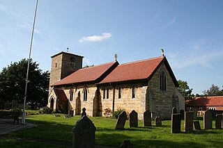
Eagle is a village in the civil parish of Eagle and Swinethorpe, in the North Kesteven district of Lincolnshire, England. It is situated 7 miles (11 km) south-west from Lincoln and 2 miles (3.2 km) east from North Scarle. The population of the civil parish of Eagle and Swinethorpe taken at the 2011 census was 793.

Bottesford is a town in North Lincolnshire, Lincolnshire, England.

Birthorpe is a hamlet in the civil parish of Billingborough, in the South Kesteven district of Lincolnshire, England. It is situated less than 1 mile (2 km) west from Billingborough and the B1177 Pointon Road, and 2 miles (3 km) east from Folkingham. Birthorpe was formerly in the parish of Semperingham, in 1866 Birthorpe became a separate civil parish, on 1 April 1931 the parish was abolished and merged with Billingborough. In 1921 the parish had a population of 46.

Keadby is a small village and former civil parish, now in the parish of Keadby with Althorpe, in the North Lincolnshire district, in the ceremonial county of Lincolnshire, England. It is situated just off the A18, west of Scunthorpe, and on the west bank of the River Trent. The civil parish of Keadby with Althorpe had a population at the 2011 census of 1,930.

Lepton is a village near Huddersfield in the parish of Kirkburton, in the Kirklees district of West Yorkshire, England. It is 4.25 miles (7 km) to the east of Huddersfield on the A642 road, 120 metres (390 ft) above the town centre directly north of Lepton Great Wood. In 1931 the parish had a population of 3,323.
Holme is a linear settlement and former civil parish, now in the parish of Messingham, in the North Lincolnshire district, in the ceremonial county of Lincolnshire, England. The population of the civil parish at the 2011 census was 113.
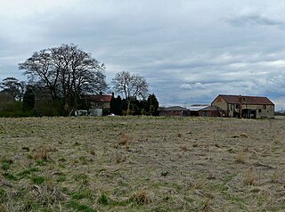
Whisby is a hamlet in the civil parish of Doddington and Whisby, in the North Kesteven district of Lincolnshire, England. It is situated 5 miles (8.0 km) south-west from Lincoln city centre, 1.5 miles (2.4 km) south from Doddington, and 2 miles (3.2 km) north from the A46 road.
Stainby is a village and former civil parish, now in the parish of Gunby and Stainby, in the South Kesteven district of Lincolnshire, England. It is situated 2 miles (3.2 km) west from the A1 road, 1.5 miles (2.4 km) east from the Viking Way and the Leicestershire border, and 8 miles (13 km) south from Grantham. In 1921 the parish had a population of 117.

Muston is a village and former civil parish, now in the parish of Bottesford, in the Melton district, in north-east Leicestershire, England. It is 18.6 miles (29.9 km) east of Nottingham, five miles (8.0 km) west of Grantham on the A52 and 12.5 miles (20.1 km) north of Melton Mowbray. It lies on the Leicestershire/Lincolnshire county border, two miles east of Bottesford. The River Devon flows through the village. In 1931 the parish had a population of 218. On 1 April 1936 the parish was abolished and merged with Bottesford.

Stroxton is a village in the civil parish of Little Ponton and Stroxton, in the South Kesteven district of Lincolnshire, England. It is situated 3 miles (4.8 km) south from the centre of Grantham and about 1 mile (1.6 km) north-west from Great Ponton and the A1 road.

Pointon is a village in the civil parish of Pointon and Sempringham, in the South Kesteven district of Lincolnshire, England. In 2021 the parish of "Pointon and Sempringham" has a population of 533. The majority of the parish's population live in Pointon. It is situated 7 miles (11.3 km) north of Bourne.

Keisby is a hamlet in the civil parish of Lenton, Keisby and Osgodby, in the South Kesteven district, in Lincolnshire, England. It is situated 6 miles (10 km) north-west from Bourne and 9 miles (14 km) south-east from Grantham. In 1921 the parish had a population of 72.

Little Ponton is a village in the civil parish of Little Ponton and Stroxton, in the South Kesteven district of Lincolnshire, England. It lies 2 miles (3 km) south of Grantham, about 60 metres (200 ft) above sea level.

Frodingham is a historic hamlet and now a suburb of Scunthorpe in the borough of North Lincolnshire, in Lincolnshire, England. The village lay directly to the south of Scunthorpe town centre, the name Frodingham is now often used to refer to the area directly to the north of the town centre.
Carrington is a village in the civil parish of Carrington and New Bolingbroke, in the East Lindsey district of Lincolnshire, England. It is situated approximately 7 miles (11 km) north from the market town of Boston.
North Owersby is a village and former civil parish, now in the parish of Owersby, in the West Lindsey district of Lincolnshire, England, and about 6 miles (10 km) north from the town of Market Rasen. In 1866 North Owersby became a civil parish, on 1 April 1936 the parish was abolished and merged with Owersby. In 1931 the parish had a population of 249.
Thorpe Tilney is a hamlet in the civil parish of Timberland, in the North Kesteven district of Lincolnshire, England. The hamlet lies directly south of Timberland, on the B1189 towards Walcott.

Little Ponton and Stroxton is a civil parish in the South Kesteven district of Lincolnshire, England. According to the 2001 Census it had a population of 135 across 62 homes, increasing to 235 at the 2011 census.

Londonthorpe and Harrowby Without is a civil parish in the South Kesteven district of Lincolnshire, England. According to the 2001 Census it had a population of 4,344, in 1743 households, increasing to a population of 5,133 at the 2011 census. It includes the village of Londonthorpe and the hamlet of Harrowby, Lincolnshire.

