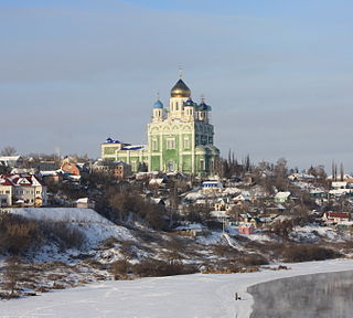
Gryazi is a town and the administrative center of Gryazinsky District in Lipetsk Oblast, Russia, located on the Matyra River 30 kilometers (19 mi) southeast of Lipetsk, the administrative center of the oblast. Population: 46,807 (2010 Census); 47,478 (2002 Census); 47,458 (1989 Census).

Chaplyginsky District is an administrative and municipal district (raion), one of the eighteen in Lipetsk Oblast, Russia. It is located in the northeast of the oblast. The area of the district is 1,520 square kilometers (590 sq mi). Its administrative center is the town of Chaplygin. Population: 32,704 (2010 Census); 36,069 ; 39,832 (1989 Census). The population of Chaplygin accounts for 38.7% of the district's total population.
Dankovsky District is an administrative and municipal district (raion), one of the eighteen in Lipetsk Oblast, Russia. It is located in the north of the oblast. The area of the district is 1,894.85 square kilometers (731.61 sq mi). Its administrative center is the town of Dankov. Population: 35,468 (2010 Census); 40,766 ; 19,040 (1989 Census). The population of Dankov accounts for 59.4% of the district's total population.

Dobrinsky District is an administrative and municipal district (raion), one of the eighteen in Lipetsk Oblast, Russia. It is located in the southeast of the oblast. The area of the district is 1,680 square kilometers (650 sq mi). Its administrative center is the rural locality of Dobrinka. Population: 37,567 (2010 Census); 40,809 ; 42,902 (1989 Census). The population of Dobrinka accounts for 25.5% of the district's total population.
Dobrovsky District is an administrative and municipal district (raion), one of the eighteen in Lipetsk Oblast, Russia. It is located in the east of the oblast. The area of the district is 1,326.4 square kilometers (512.1 sq mi). Its administrative center is the rural locality of Dobroye. Population: 24,228 (2010 Census); 26,821 ; 28,723 (1989 Census). The population of Dobroye accounts for 22.5% of the district's total population.

Dolgorukovsky District is an administrative and municipal district (raion), one of the eighteen in Lipetsk Oblast, Russia. It is located in the southwest of the oblast. The area of the district is 990 square kilometers (380 sq mi). Its administrative center is the rural locality of Dolgorukovo. Population: 18,623 (2010 Census); 21,127 ; 23,488 (1989 Census). The population of Dolgorukovo accounts for 28.7% of the district's total population.

Gryazinsky District is an administrative and municipal district (raion), one of the eighteen in Lipetsk Oblast, Russia. It is located in the southeast of the oblast. The area of the district is 1,360 square kilometers (530 sq mi). Its administrative center is the town of Gryazi. Population: 75,159 (2010 Census); 73,622 ; 26,821 (1989 Census). The population of Gryazi accounts for 62.3% of the district's total population.

Izmalkovsky District is an administrative and municipal district (raion), one of the eighteen in Lipetsk Oblast, Russia. It is located in the west of the oblast. The area of the district is 1,130 square kilometers (440 sq mi). Its administrative center is the rural locality of Izmalkovo. Population: 17,281 (2010 Census); 18,813 ; 20,404 (1989 Census). The population of Izmalkovo accounts for 23.2% of the district's total population.

Khlevensky District is an administrative and municipal district (raion), one of the eighteen in Lipetsk Oblast, Russia. It is located in the south of the oblast. The area of the district is 910 square kilometers (350 sq mi). Its administrative center is the rural locality of Khlevnoye. Population: 20,208 (2010 Census); 22,251 ; 24,106 (1989 Census). The population of Khlevnoye accounts for 29.5% of the district's total population.

Krasninsky District is an administrative and municipal district (raion), one of the eighteen in Lipetsk Oblast, Russia. It is located in the northwest of the oblast. The area of the district is 980 square kilometers (380 sq mi). Its administrative center is the rural locality of Krasnoye. Population: 13,498 (2010 Census); 15,728 ; 16,335 (1989 Census). The population of Krasnoye accounts for 28.4% of the district's total population.

Lebedyansky District is an administrative and municipal district (raion), one of the eighteen in Lipetsk Oblast, Russia. It is located in the northern central part of the oblast. The area of the district is 1,445 square kilometers (558 sq mi). Its administrative center is the town of Lebedyan. Population: 43,178 (2010 Census); 46,644 ; 46,250 (1989 Census). The population of Lebedyan accounts for 48.7% of the district's total population.

Lev-Tolstovsky District is an administrative and municipal district (raion), one of the eighteen in Lipetsk Oblast, Russia. It is located in the north of the oblast. The area of the district is 968 square kilometers (374 sq mi). Its administrative center is the rural locality of Lev Tolstoy. Population: 17,141 (2010 Census); 17,862 ; 17,748 (1989 Census). The population of Lev Tolstoy accounts for 50.5% of the district's total population.

Lipetsky District is an administrative and municipal district (raion), one of the eighteen in Lipetsk Oblast, Russia. It is located in the center of the oblast. The area of the district is 1,510 square kilometers (580 sq mi). Its administrative center is the city of Lipetsk. Population: 49,258 (2010 Census); 48,383 ; 48,223 (1989 Census).

Stanovlyansky District is an administrative and municipal district (raion), one of the eighteen in Lipetsk Oblast, Russia. It is located in the northwest of the oblast. The area of the district is 1,350 square kilometers (520 sq mi). Its administrative center is the rural locality of Stanovoye. Population: 18,746 (2010 Census); 20,424 ; 21,650 (1989 Census). The population of Stanovoye accounts for 28.0% of the district's total population.

Terbunsky District is an administrative and municipal district (raion), one of the eighteen in Lipetsk Oblast, Russia. It is located in the southwest of the oblast. The area of the district is 1,170 square kilometers (450 sq mi). Its administrative center is the rural locality of Terbuny. Population: 22,536 (2010 Census); 24,068 ; 25,752 (1989 Census). The population of Terbuny accounts for 32.4% of the district's total population.

Usmansky District is an administrative and municipal district (raion), one of the eighteen in Lipetsk Oblast, Russia. It is located in the southeast of the oblast. The area of the district is 1,910 square kilometers (740 sq mi). Its administrative center is the town of Usman. Population: 50,906 (2010 Census); 54,027 ; 57,637 (1989 Census). The population of Usman accounts for 36.7% of the district's total population.

Volovsky District is an administrative and municipal district (raion), one of the eighteen in Lipetsk Oblast, Russia. It is located in the southwest of the oblast. The area of the district is 796 square kilometers (307 sq mi). Its administrative center is the rural locality of Volovo. Population: 14,632 (2010 Census); 16,374 ; 18,583 (1989 Census). The population of Volovo accounts for 25.5% of the district's total population.

Zadonsky District is an administrative and municipal district (raion), one of the eighteen in Lipetsk Oblast, Russia. It is located in the southern central part of the oblast. The area of the district is 1,503 square kilometers (580 sq mi). Its administrative center is the town of Zadonsk. Population: 34,959 (2010 Census); 37,244 ; 39,281 (1989 Census). The population of Zadonsk accounts for 27.7% of the district's total population.

Volovo is a rural locality and the administrative center of Volovsky District of Lipetsk Oblast, Russia. Population: 3,734 (2010 Census); 4,072 (2002 Census); 4,307 (1989 Census).