
The Beaver Dam Mountains Wilderness is a wilderness area located in northwestern Arizona and southwestern Utah, USA, within the arid Colorado Plateau region. The jagged mountains and gently sloping alluvial plain of the Beaver Dam Mountains straddle the border between the two states. The Wilderness contains some of the lowest elevation land in Utah, and includes a 13 miles (21 km) section of the Virgin River Gorge. The area comprises some 18,667 acres (7,554 ha), 15,000 acres (6,100 ha) of which in Arizona and approximately 3,667 acres (1,484 ha) in Utah. The area was designated Wilderness by the U.S. Congress in 1984 and is administered by the Bureau of Land Management.
The Star Range is an 8-mile (12 km) long, small mountain range located in central Beaver County, Utah. The range is "star"-shaped as small ridges end at peaks, like fingers of a hand. Another adjacent range sequence southwest, the Shauntie Hills has other fingers of the star-shape.
The Bull Valley Mountains are a 30-mi (48 km) long, mountain range in southwest Utah, located in northwest Washington County. The range is adjacent the Utah border and attached to the Clover Mountains of southeast Nevada. The Great Basin Divide transects the summits of both ranges, with the Escalante Desert north and northeast of the Bull Valley Mountains, and south of the mountains the Colorado River watershed, and specifically the Santa Clara River which drains southeasterly from an escarpment along the mountain range's southeast flank.
The Canyon Mountains are a 25-mile (40 km) long mountain range located in the northeast corner of Millard County, Utah; the range is bisected north-south with a southeast border section of Juab County.
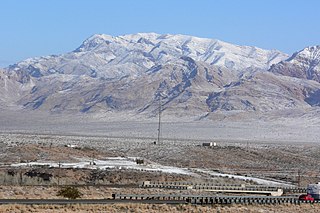
The Beaver Dam Mountains are a 23 miles (37 km) long mountain range located mostly in extreme southwest Washington County, Utah, west of St. George, with the south of the range extending into the Arizona Strip.

The Cedar Mountains of Tooele County, Utah, USA, are a 45-mile (72 km) long mountain range located in the county's east, bordering east sections of the Great Salt Lake Desert on the range's west and southwest flanks.

The Lakeside Mountains are about a 34 miles (55 km) long mountain range located on the southwest perimeter of the Great Salt Lake; the range is located in northeast Tooele County and south Box Elder County in Utah, United States.

The Hurricane Cliffs of southwest Utah and northwest Arizona are a red, limestone geographic feature, sets of cliffs along the western, eroded edge of the Kaibab Limestone; the cliffs are about 135-mi (217 km) long, with the south end terminus just north of the Grand Canyon. The cliffs are associated with the Hurricane Fault.
The Black Mountains is a 30-mile (48 km) long mountain range in northeastern Iron County and southeastern Beaver County in southwestern Utah, United States.
The Sheeprock Mountains are a 24-mile (39 km) long mountain range located in extreme southeast Tooele County, Utah, and part of northeast Juab County. The range trends southeasterly and forms a section of the northeast perimeter of the large Sevier Desert, which lies southwest of the Sheeprock Mountains.

The Mineral Mountains are a 28 miles (45 km) long mountain range located in eastern Beaver and southeastern Millard counties in southwestern Utah. The Escalante Desert is to its southwest, the Black Rock Desert volcanic field and the Sevier Desert are to the north and northwest. The Pavant Range and Tushar Mountains lie to the east.
The Moccasin Mountains is an 11-mile-long (18 km) mountain range located at the Arizona–Utah border in Mohave County, Arizona, and a small north section in Kane County, Utah.
Buckskin Mountain is a 16-mile (26 km) mountain ridge that spans from Coconino County, Arizona to Kane County, Utah in the United States, that is divided almost equally between the two counties.

The Red Mountains of Washington County, Utah, United States, is a mostly circular 7 miles (11 km) long mountain range.

The Valley Mountains are a 28-mile-long (45 km) mountain range located on the southwest border of Sanpete County, Utah, United States, with the northeast border of Millard County. The north of the range is in Juab County; the south in Sevier County.

The Kanab Plateau is a 45-mile long plateau located at the north of the Grand Canyon in Arizona, United States. The plateau is adjacent west of the Kaibab Plateau of the North Rim, with a basin containing the Kanab Creek watershed in between. The basin is the site of the Kanab Creek Wilderness, with Snake Gulch at its north perimeter, and at the base of the Kanab Plateau, forming its southeast border.

The Long Valley of Utah is a 13-mile (21 km) long valley located in western Kane County. The valley is located in source water regions of waters flowing north, south, and southwest, in the west of the High Plateaus section of the Colorado Plateau; the High Plateaus section also extends into northern Arizona, the region north of the Grand Canyon.

Chinle Valley is a 65-mile (105 km) long valley located mostly in Apache County Arizona. Chinle Creek continues north into Utah to meet the San Juan River (Utah).
The Defiance Plateau, part of the geologic Defiance Uplift, is an approximately 75-mile (121 km) long, mostly north-trending plateau of Apache County, Arizona, with its east and southeast perimeter, as parts of San Juan and McKinley Counties, New Mexico.
The Peacock Mountains are a small, 26 mi (42 km) long mountain range in northwest Arizona, US. The range is a narrow sub-range, and an extension north, at the northeast of the Hualapai Mountains massif, which lies to the southwest. The range is defined by the Hualapai Valley to the northwest, and north and south-flowing washes on its east border, associated with faults and cliffs; the Cottonwood Cliffs are due east, and are connected to the Aquarius Cliffs southward at the west perimeter of the Aquarius Mountains; the cliffs are a result of the Aquarius Fault, which is an extension southward from the Grand Wash Cliffs and Grand Wash Fault which crosses the Colorado River at Lake Mead, and the west perimeter of the Grand Canyon/Colorado Plateau.


