
The University of Texas at Austin is a public research university in Austin, Texas. It was founded in 1883 and is the flagship institution of the University of Texas System. The University of Texas was inducted into the Association of American Universities in 1929, becoming only the third university in the American South to be elected. The institution has the nation's eighth-largest single-campus enrollment, with over 50,000 undergraduate and graduate students and over 24,000 faculty and staff. As of December 2018, it also has the second-largest endowment among higher-education institutions in the US, surpassed in wealth only by Harvard University.

Fort Worth is the 15th-largest city in the United States and the fifth-largest city in the state of Texas. It is the county seat of Tarrant County, covering nearly 350 square miles (910 km2) into four other counties: Denton, Johnson, Parker and Wise. According to the 2017 census estimates, Fort Worth's population is 874,168. The city is the second-largest in the Dallas–Fort Worth–Arlington metropolitan area, which is the 4th most populous metropolitan area in the United States.

Stephen Fuller Austin was an American empresario. Known as the "Father of Texas", and the founder of Texas, he led the second, and ultimately, the successful colonization of the region by bringing 300 families from the United States to the region in 1825.
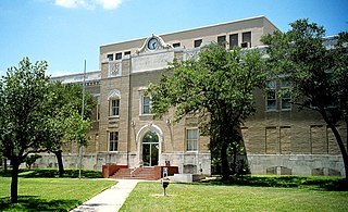
San Patricio County is a county in the U.S. state of Texas. As of the 2010 census, the population was 64,804. Its county seat is Sinton.
Scouting in Texas has a long history, from the 1910s to the present day, serving thousands of youth in programs that suit the environment in which they live. Scouting, also known as the Scout Movement, is a worldwide youth movement with the stated aim of supporting young people in their physical, mental and spiritual development, so that they may play constructive roles in society.
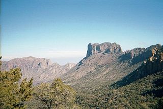
The Big Bend is a colloquial name of a geographic region in the western part of the state of Texas in the United States along the border with Mexico, roughly defined as the counties north of the prominent northward bend in the Rio Grande as it passes through the gap between the Chisos Mountains in Texas and the Sierra Madre Oriental in Mexico. It is sometimes loosely defined as the part of Texas south of U.S. Highway 90 and west of the Pecos River. The region includes three counties in Texas: Brewster, Jeff Davis and Presidio.

Big Thicket is the name of a heavily forested area in Southeast Texas, United States. Several attempts to provide boundaries have been made ranging from only a 10 to 15 mile section of Hardin County to an area encompassing over 29 counties and over 3,350,000 acres. Scientific studies have been performed also, but with varying results. In "... 1936, ... Hal B. Parks and Victor L. Cory of the Texas Agriculture Experiment station conducted a biological survey of the Big Thicket region". Their study, based on geology, resulted in over 3,350,000 acres of Southeast Texas and covering 14 counties from Houston in the west to Orange in the east and Huntsville to Wiergate on the north. Claude McLeod, a botany professor at Sam Houston State University, performed a botanical based study, resulting in a region of over 2,000,000 acres. While no exact boundaries exist, the area occupies much of Hardin, Liberty, Tyler, San Jacinto, and Polk Counties and is roughly bounded by the San Jacinto River, Neches River, and Pine Island Bayou. To the north, it blends into the larger Piney Woods terrestrial ecoregion of which it is a part. It has historically been the most dense forest region in what is now Texas, though logging in the 19th and 20th centuries dramatically reduced the forest concentration.

Lake Conroe is a 21,000-acre (85 km2) lake in Montgomery County, Texas, United States. Even though it is named Lake Conroe, only a small portion of the lake is in Conroe, Texas. Most of the lake is in unincorporated Montgomery County. The lake lies on the West Fork of the San Jacinto River, just west of Interstate 45 off State Highway 105 in Montgomery and Walker counties. Lake Conroe is a popular attraction for boating, jet-skiing, and fishing.

The Texas and Pacific Railway Company was created by federal charter in 1871 with the purpose of building a southern transcontinental railroad between Marshall, Texas, and San Diego, California.

Mother Neff State Park is a 259-acre (105 ha) state park located on the Leon River west of Moody, Texas in Coryell County. The park is part of Mother Neff State Park and F.A.S. 21-B(1) Historic District, which was added to the National Register of Historic Places on October 2, 1992.

The Lady Bird Johnson Wildflower Center at The University of Texas at Austin is the state botanical garden and arboretum of Texas. The center features more than 900 species of native Texas plants in both garden and natural settings and is home to a breadth of educational programs and events. The center is 284 acres and located 10 miles southwest of downtown Austin, Texas just inside the edge of the distinctive Texas hill country. It straddles both Edwards Plateau and Texas Blackland Prairies ecosystems.
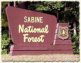
Sabine National Forest is located in East Texas near the Texas-Louisiana border. The forest is administered together with the other three United States National Forests and two National Grasslands located entirely in Texas, from common offices in Lufkin, Texas. There are local ranger district offices located in Hemphill.

Davy Crockett National Forest is off U.S. Highway 69 lying west of Lufkin, Texas and east of Crockett. It is administered by the United States Department of Agriculture Forest Service local headquarters in Lufkin. There are local ranger district offices located in Ratcliff.

Monument Hill and Kreische Brewery State Historic Sites is a historic state park located at 29.888° -96.876°, just off U.S. Route 77, south of La Grange, Texas. The park sits on a sandstone bluff above the Colorado River. Monument Hill is a crypt and memorial to the men who died in the Dawson Massacre and in the Black Bean Episode of the ill-fated Mier Expedition.

Buescher State Park is a state park located just north of Smithville, Texas. The park consists of 1,016.7 acres (411 ha) of public land donated to the state by Mr. Emil and Mrs. Elizabeth Buescher, as well as the City of Smithville.

Bastrop State Park is a state park in Bastrop County in Central Texas. The park was established in 1938 and consists of stands of loblolly pines mixed with post oak and junipers.
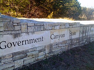
First opened to the public in October, 2005, Government Canyon State Natural Area (GCSNA) preserves 12,244 acres of rugged hills and canyons typical of the Texas Hill Country. It is designated a Natural Area, rather than a State Park, and therefore the primary focus is maintenance and protection of the property's natural state. Accordingly, access and recreational activities may be restricted if the Texas Parks & Wildlife Department (TPWD) deems such action necessary to protect the environment.

Palo Pinto Mountains State Park is an undeveloped 4,000 plus acre state park in Palo Pinto and Stephens County, Texas near the City of Strawn. The park is located in the Western Cross Timbers Ecoregion. The park is administered by the Texas Parks and Wildlife Department which bought the property from private landowners in October 2011. The park has not received any development money and is not yet open to the public.

Hell's Half Acre was a precinct of Fort Worth, Texas designated as a red-light district beginning the early to mid 1870s in the Old Wild West. It came to be called the town's "Bloody Third ward" because of the violence and lawlessness in the area.
Amada Acres is a census-designated place (CDP) in Starr County, Texas, United States. It is a new CDP formed from part of the former La Casita-Garciasville CDP prior to the 2010 census with a population of 92.


