
A valley is a low area between hills or mountains typically with a river running through it. In geology, a valley or dale is a depression that is longer than it is wide. The terms U-shaped and V-shaped are descriptive terms of geography to characterize the form of valleys. Most valleys belong to one of these two main types or a mixture of them, at least with respect to the cross section of the slopes or hillsides.

The Rio Grande is one of the principal rivers in the southwest United States and northern Mexico. The Rio Grande begins in south-central Colorado in the United States and flows to the Gulf of Mexico. After passing through the length of New Mexico along the way, it forms part of the Mexico–United States border. According to the International Boundary and Water Commission, its total length was 1,896 miles (3,051 km) in the late 1980s, though course shifts occasionally result in length changes. Depending on how it is measured, the Rio Grande is either the fourth- or fifth-longest river system in North America.

Collin County is a county in the U.S. state of Texas. As of the 2010 United States Census, the county's population was 782,341, making it the seventh-most populous county in Texas and the 45th-largest county by population in the United States. The 2010 Census for Collin County's population was 782,341, and reached 1,005,146 in 2018. Its county seat is McKinney.
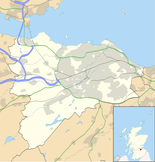
Dean Village is a former village immediately northwest of the city centre of Edinburgh, Scotland. It was known as the "Water of Leith Village" and was the centre of a successful grain milling area for more than 800 years. At one time there were no fewer than eleven working mills there, driven by the strong currents of the Water of Leith.
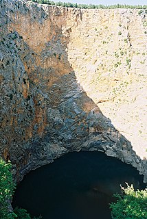
A sinkhole, also known as a cenote, sink, sink-hole, swallet, swallow hole, or doline, is a depression or hole in the ground caused by some form of collapse of the surface layer. Most are caused by karst processes – the chemical dissolution of carbonate rocks or suffosion processes. Sinkholes vary in size from 1 to 600 m both in diameter and depth, and vary in form from soil-lined bowls to bedrock-edged chasms. Sinkholes may form gradually or suddenly, and are found worldwide.

Groundwater is the water present beneath Earth's surface in soil pore spaces and in the fractures of rock formations. A unit of rock or an unconsolidated deposit is called an aquifer when it can yield a usable quantity of water. The depth at which soil pore spaces or fractures and voids in rock become completely saturated with water is called the water table. Groundwater is recharged from the surface; it may discharge from the surface naturally at springs and seeps, and can form oases or wetlands. Groundwater is also often withdrawn for agricultural, municipal, and industrial use by constructing and operating extraction wells. The study of the distribution and movement of groundwater is hydrogeology, also called groundwater hydrology.

A spring is a point at which water flows from an aquifer to the Earth's surface. It is a component of the hydrosphere.
In oceanography, a halocline is a subtype of chemocline caused by a strong, vertical salinity gradient within a body of water. Because salinity affects the density of seawater, it can play a role in its vertical stratification. Increasing salinity by one kg/m3 results in an increase of seawater density of around 0.7 kg/m3.

Deep Creek Conservation Park, formerly the Deep Creek National Park, is a protected area in the Australian state of South Australia located on the southern coast of Fleurieu Peninsula in the gazetted localities of Deep Creek and Delamere about 11 kilometres east of Cape Jervis.

Weybridge railway station is near the established midpoint of Weybridge in Surrey, England and south of its town centre. It is on the South Western Main Line and operated by South Western Railway.

A tourist trap is an establishment that has been created or re-purposed with the aim of attracting tourists and their money.

Curtis Bay is a residential / commercial / industrial neighborhood in the southern portion of the City of Baltimore, Maryland, United States.
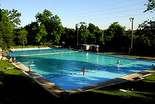
Deep Eddy Pool is a historic, man-made swimming pool in Austin, Texas. Deep Eddy is the oldest swimming pool in Texas and features a bathhouse built during the Depression era by the Works Progress Administration. The pool began as a swimming hole in the Colorado River, became a resort in the 1920s, and is today a popular swimming pool operated by the City of Austin.
The Texas rig is a technique used for fishing with soft plastic lures. It involves a bullet-shaped weight being threaded onto the fishing line first, followed by a glass or plastic bead, and then the line is secured to a hook, usually an offset worm hook.
Bar Point is a suburb of the Central Coast region of New South Wales, Australia, located on the north bank of the Hawkesbury River 53 kilometres (33 mi) north of Sydney. It is part of the Central Coast Council local government area.
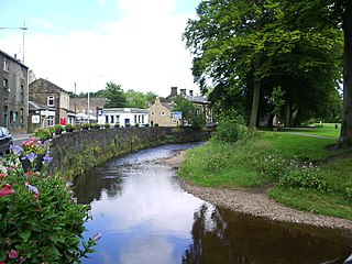
Pendle Water is a minor river in Lancashire.

Rosharon, also known as "Buttermilk Station," is an unincorporated community and census-designated place (CDP) in Brazoria County, Texas, United States, at the intersection of Farm to Market Road 521 and Farm to Market Road 1462. As of the 2010 census, it had a population of 1,152.

Balcones Canyonlands is a national wildlife refuge located in the Texas Hill Country to the northwest of Austin. The refuge was formed in 1992 to conserve habitat for two endangered songbirds including the golden-cheeked warbler and the black-capped vireo and to preserve Texas Hill Country habitat for numerous other wildlife species. The refuge augments a similarly named preserve in Austin called the Balcones Canyonlands Preserve.

The River Eitha is a small river in Wrexham County Borough, Wales. It is part of the River Dee catchment. Its name was probably derived from the Welsh word eithaf - "extremity", "farthest".

Dade Phelan is an American real estate developer and politician who is a Republican member of the Texas House of Representatives for District 21, which encompasses half of Jefferson County and all of neighboring Orange County in the far southeastern corner of the state.


