Yungngora Community, Western Australia

Last updated • 3 min readFrom Wikipedia, The Free Encyclopedia

Yungngora Community
Western Australia
Australia Western Australia location map.svg
Red pog.svg
Yungngora Community
Yungngora Community, Western Australia
Coordinates 18°30′00″S124°50′00″E / 18.50000°S 124.83333°E / -18.50000; 124.83333
Population416 (ILOC 2021) [1]
Postcode(s) 6765
Location
LGA(s) Shire of Derby-West Kimberley
State electorate(s) Kimberley
Federal division(s) Durack

Yungngora is a medium-sized Aboriginal community in the Kimberley region in northern Western Australia, situated approximately 280 km east-south-east of Broome and 100 km south-west of Fitzroy Crossing. At the 2016 census, Yungngora had a population of 378. [2]

Contents

Background

The community is located on the Noonkanbah Station on the banks of the Fitzroy River between Camballin and Fitzroy Crossing. Yungngora is the gateway to communities further inland such as Kadjina Community and Yakanarra Community. The main access road is unpaved and so becomes inaccessible during the wet season.

History

Some members of the Yungngora people were removed to Beagle Bay Community as part of the Stolen Generation.

The pastoral lease at Noonkanbah was purchased for the community in 1976. Great controversy surrounded the township when its citizens opposed the exploratory oil drilling at a sacred site on the station by the American oil miner AMAX in 1979. [3] [4] [5]

In 2001 land on Noonkanbah was returned to the community. [6]

Education

Yungngora Community has a school, Kulkarriya Community School, which was established in 1978 for students from pre-primary to Year 12 in the Western Australian education system. The primary and secondary school population for the year 2007 was 87. [7]

Town planning

Yungngora Layout Plan No.2 was prepared in accordance with State Planning Policy 3.2 Aboriginal Settlements and was endorsed by the community and Western Australian Planning Commission in 2009. The layout plan map-set and background report can be viewed at Planning Western Australia's web site. [8]

Facilities

Electricity supply

Electricity supply is currently regularised and now managed by Horizon Power, under the state government-funded Aboriginal and Remote Community Power Station Project.

The power station has four 300kW Scania diesel engines and a 200kW solar photovoltaic array (fixed). It uses battery storage to smooth any fluctuations in the solar output. Horizon Power contracted GHD to deliver the solar power integration into the diesel power station and MPower were engaged as the site contractor to deliver the solar installation.

As with many remote Aboriginal communities, residents and businesses will use pre-payment cards to pay for electricity and will be eligible to receive electricity at government-gazetted uniform tariff rates.

Water

There are two bores next to the power station which pump into the ground tank. The bores pump the water from approximately 100 metres from below the ground level, despite the community being situated on the banks of the Fitzroy River. A transfer pump station then pumps the water into the high level tank. The water has been recorded as coming out of the ground at between 50 and 60 degrees C. It is this condition which has prompted the installation of cooling towers. There are occasional interruptions.

Sewerage

There is a sewer system in place in the community which comprises one pump station near the football oval and treatment ponds on the northern outskirts of the community.

Recreation

The community has basketball courts and a football oval. Yungngora fields a team in the Central Kimberley Football League called the "Noonkanbah Blues".

Bush walking, some fishing and camping are the dominant pursuits for tourists visiting. Visitors are required to apply for a permit prior to entering the Community.

Shopping

There is one store in town, owned and operated by the Community. All items are quite expensive compared to major centres but due to transport costs to remote locations. Mechanical repairs may be effected at the mechanical workshop.

See also

Related Research Articles

<span class="mw-page-title-main">Fitzroy Crossing, Western Australia</span> Town in Western Australia

Fitzroy Crossing is a small town in the Kimberley region of Western Australia, 400 kilometres (250 mi) east of Broome and 300 kilometres (190 mi) west of Halls Creek. It is approximately 2,524 kilometres (1,568 mi) from the state capital of Perth. It is 114 metres (374 ft) above sea level and is situated on a low rise surrounded by the vast floodplains of the Fitzroy River and its tributary Margaret River.

<span class="mw-page-title-main">Off-the-grid</span> Not being connected to public utilities

Off-the-grid or off-grid is a characteristic of buildings and a lifestyle designed in an independent manner without reliance on one or more public utilities. The term "off-the-grid" traditionally refers to not being connected to the electrical grid, but can also include other utilities like water, gas, and sewer systems, and can scale from residential homes to small communities. Off-the-grid living allows for buildings and people to be self-sufficient, which is advantageous in isolated locations where normal utilities cannot reach and is attractive to those who want to reduce environmental impact and cost of living. Generally, an off-grid building must be able to supply energy and potable water for itself, as well as manage food, waste and wastewater.

<span class="mw-page-title-main">Fitzroy River (Western Australia)</span> River in Western Australia

The Fitzroy River is located in the West Kimberley region of Western Australia. It has 20 tributaries and its catchment occupies an area of 93,829 square kilometres (36,228 sq mi), within the Canning Basin and the Timor Sea drainage division.

<span class="mw-page-title-main">Kalumburu, Western Australia</span> Community in Western Australia

Kalumburu and Kalumburu Community are both bounded localities within the Shire of Wyndham-East Kimberley in Western Australia. Kalumburu Community is the northernmost settlement in Western Australia.

<span class="mw-page-title-main">Hybrid power</span> Combinations between different technologies to generate electric power

Hybrid power are combinations between different technologies to produce power.

Looma is an Aboriginal community about 120 km south-east of Derby adjacent the Fitzroy River in the Kimberley region of Western Australia. At the 2011 census, Looma had a population of 374.

Noonkanbah Station is a pastoral lease, both a cattle and sheep station, on the Fitzroy River between Camballin and Fitzroy Crossing in the south central Kimberley region of Western Australia.

Kadjina is a community situated approximately 300 km ESE of Broome and 100 km SW of Fitzroy Crossing in the central south of the Kimberley region of Western Australia.

Beagle Bay is a medium-sized Aboriginal community on the western side of the Dampier Peninsula, north of Broome in the Kimberley region of Western Australia.

Kaltukatjara, also known as Docker River, is a remote Indigenous Australian community in the Northern Territory of Australia. It is southwest of Alice Springs, west of the Stuart Highway, near the Western Australia and Northern Territory border. The township is on a wadi called the Docker Creek on the north side of the west end of the Petermann Ranges in the southwest corner of the Northern Territory of Australia.

<span class="mw-page-title-main">Louisa Downs Station</span> Pastoral lease in Western Australia

Louisa Downs, also commonly just referred to as "Louisa", is a large cattle station midway between Fitzroy Crossing and Halls Creek in the Kimberley region in Western Australia.

<span class="mw-page-title-main">Fossil Downs Station</span> Station in North East of Fitzroy Crossing, Western Australia

Fossil Downs Station is a pastoral lease and cattle station located about 50 kilometres (31 mi) north east of Fitzroy Crossing in the Kimberley region of Western Australia.

Jarlmadangah Burru is an Aboriginal community located 86 kilometres (53 mi) southeast of Derby in the Kimberley region of Western Australia, within the Shire of Derby-West Kimberley.

Ngalingkadji is a small Aboriginal community located within the Shire of Derby–West Kimberley in Western Australia. It is located south-east of Fitzroy Crossing; 54 km by the sealed Great Northern Highway and 9 km by the unsealed Cherrabun Road. Ngalingkadji community is also referred to as Chestnut Bore.

Djugerari is a small Aboriginal community located within the Shire of Derby-West Kimberley.

Jimbalakudunj is a small Aboriginal community located approximately 100 kilometres (62 mi) north west of Fitzroy Crossing in the Kimberley region of Western Australia, within the Shire of Derby–West Kimberley.

Yakanarra is a small Aboriginal community approximately 60 kilometres south-west of Fitzroy Crossing in the Kimberley region of Western Australia, within the Shire of Derby-West Kimberley. Road access is via the Cherabun Road, which intersects the Great Northern Highway 57 km east of Fitzroy Crossing.

Bayulu is a large Aboriginal community located 10 km south of Fitzroy Crossing in the Kimberley region of Western Australia, within the Shire of Derby–West Kimberley. At the 2011 census, Bayulu had a population of 320.

Mowanjum is a medium-sized Aboriginal community, located 10 km (6 mi) south east of Derby in the Kimberley region of Western Australia, within the Shire of Derby-West Kimberley. At the 2016 Australian census, Mowanjum had a population of 311.

<span class="mw-page-title-main">Gogo Station</span> Pastoral lease in Western Australia

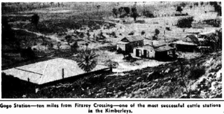
Gogo or Gogo Station and sometimes referred to as Margaret Downs is a pastoral lease that has operated as a cattle station. It is located about 11 kilometres (7 mi) south of Fitzroy Crossing and 83 kilometres (52 mi) north east of Yungngora in the Kimberley region of Western Australia.

References

  1. Australian Bureau of Statistics (28 June 2022). "Yungngora (Indigenous Location)". Australian Census 2021 QuickStats. Retrieved 29 July 2022.  OOjs UI icon edit-ltr-progressive.svg
  2. Australian Bureau of Statistics (27 June 2017). "Yungngora (L) (Urban Centre/Locality)". 2016 Census QuickStats. Retrieved 18 September 2016. OOjs UI icon edit-ltr-progressive.svg
  3. Andrea Mayes (23 December 2007). "Sir Charles Court dead at 96". news.com.au. Retrieved 23 December 2007.
  4. Hawke, Steve; Gallagher, Michael (1989), Noonkanbah, whose land, whose law, Fremantle Arts Centre Press, ISBN   978-0-949206-55-8
  5. Vassiley, Alexis (2021). "Noonkanbah 1979: When Unionists Stood up for Aboriginal Rights". Commons Social Change Library.
  6. Noonkanbah land handed back to Yungngora community, 2001, retrieved 21 July 2023
  7. Association of Independent Schools (AICS Support Unit). "Kulkarriya Community School". Archived from the original on 23 August 2006. Retrieved 26 December 2006.
  8. "Layout plans". Department of Planning, Lands and Heritage. 20 February 2020. Retrieved 10 February 2021.