Zamora, Michoacán

Last updated • 7 min readFrom Wikipedia, The Free Encyclopedia
Zamora de Hidalgo, Michoacán
Zamarat
Plaza de armas y catedral de Zamora.jpg
Plaza de Armas of Zamora
Escudo del municipio de Zamora.png
Motto: 
Cradle of Illustrious Men
Mexico Michoacan location map.svg
Red pog.svg
Zamora de Hidalgo, Michoacán
Mexico States blank map.svg
Red pog.svg
Zamora de Hidalgo, Michoacán
Coordinates: 19°59′N102°17′W / 19.983°N 102.283°W / 19.983; -102.283
Country Mexico
State Michoacán
Municipality Zamora
Foundation18 January 1574;451 years ago (1574-01-18)
Founded by Martín Enríquez de Almanza
Named for Zamora, Spain
Government
  MayorCarlos Alberto Soto Delgado
Area
  City
20.6 km2 (8.0 sq mi)
Elevation
1,580 m (5,184 ft)
Population
 (2020)
  City
186,102
  Density9,000/km2 (23,000/sq mi)
   Metro
273,641
Time zone UTC-6 (Central Standard Time)
  Summer (DST) UTC-5 (Central Daylight Time)
Zip code
59600–59725
Website http://www.zamora.gob.mx

Zamora de Hidalgo (Spanish pronunciation: [saˈmoɾadeiˈdalɢo] ) is a city in the Mexican state of Michoacán. The 2010 census population was 141,627. [1] making it the third largest city in the state. The city is the municipal seat of Zamora Municipality, which has an area of 330.97 km2 (127.79 sq mi) and includes many other smaller communities, the largest of which is Ario de Rayón (formerly known as Ario de Santa Mónica). The municipality's population is around 186,102, [1] which makes it the second most populous urban area in the state.

Contents

The city of Zamora is an important economic center in the state and the most significant population center between the cities of Morelia and Guadalajara. The city is located on the Tarascan Plateau in the northwestern part of the state, at an elevation of 1,567 m (5,141 ft) above sea level. Zamora is surrounded by the fertile Tziróndaro Valley which is an important agricultural area that exports large amounts of produce to the United States.

Toponymy

The city was named after the Spanish city of Zamora because the first European settlers to the area were predominantly from the Spanish province of Castilla y León. Zamora is of Iberian origins that can be traced to the Latin "Civitas Murata" meaning "The Walled City" because it is surrounded by high hills. In 1953, the city officially added "de Hidalgo" to honor Miguel Hidalgo y Costilla that declared the village a city during the movement to independence in Mexico.

History

Cathedral of Zamora from the Spanish Colonial Era in the historic district, Plaza de Armas. Catedral de Zamora Michoacan.jpg
Cathedral of Zamora from the Spanish Colonial Era in the historic district, Plaza de Armas.

Evidence shows the area was first settled around 1500 BC. During the Pre-Columbian Period there were several waves of migrations into the area by surrounding tribes: Pirinda, Nahua, Huetamo, Colima, and Purépecha. Zamora sits in the Tziróndaro Valley which means "swamp place" in the Purépecha language. [2]

The village of Zamora was founded on January 18, 1574, on the orders of Viceroy Martín Enríquez de Almanza, by Spanish settlers from the Spanish city of Zamora. The Spanish were attracted to the area because of fertile valleys in the region that were well suited for agricultural development.

Zamora was awarded city status by the Constituent Congress in 1825, ratifying a decision made on November 21, 1810 by the Mexican War of Independence revolutionary leader Miguel Hidalgo y Costilla. During the 19th century, Zamora developed into a great cultural and economic center due to high agricultural productivity and flourishing commerce. On December 10, 1831, Zamora was declared the municipal seat. Later the city's elite began a political movement to create a new state in which Zamora would be the state capital. In 1846, Archbishop Pelagio Antonio de Labastida y Dávalos initiated a clerical separation from Mexico City. By 1862 a new ecclesiastical office was founded, Dioceses of Zamora based in Zamora. The political aspirations to separate from the rest of the state were impeded.

During the Porfiriato the city experienced the fastest economic growth in its history. Between 1854 and 1910, the city experienced rapid economic growth due industrial development, city modernization, technological innovations, and increased agricultural productivity. Zamora was one of the first cities in the state that implemented new technologies like: railroad stations, telegraphs, telephones, electricity, modern water systems. In 1899 the department of transportation connected Zamora by railroad to other important populations centers in central Mexico. At the same time the department of urbanization had an image they wanted for the city which involved many modernization projects throughout the city. During the Porfiriato the city had an architectural renaissance celebrating many vogue European architectural styles. Large civil offices and religious temples were erected during this time that flaunted the economic wealth of the city like: Michoacán Center for the Arts, College of Michoacán, and Obrero de Zamora Theatre. On February 2, 1898 at the feast of Candlemas led by the second bishop of Zamora, Don Jose Ma. Càzares y Martinez the cornerstone of the Cathedral of Our Lady of Guadalupe was laid. During this time many of the city's elite built new homes largely inspired by Victorian and Châteauesque architectural styles.

The Mexican Revolution reached the state in 1911, when those loyal to Francisco I. Madero proclaimed the city and surrounding area their territory. When the state governor resigned the city would continue to be involved in the war. In 1918 the state ratified the state constitution. After the Mexican Revolution, the Cristero War continued to devastate the region's agriculture which had detrimental economic effects to the city. Political hostilities would finally end in the city and vicinity in 1926.

Geography

Tzirondaro Valley Arroyo de Michoacan.jpg
Tziróndaro Valley

Zamora de Hidalgo is located in the northwestern part of the state of Michoacán on the Tarascan Plateau at an elevation of 1,567 m 5,141 ft) above sea level. The city is the municipal seat of Zamora Municipality, which has an area of 330.97 km2 (127.79 sq mi) and includes many other smaller communities, the largest of which is Ario de Rayón (Ario Santa Mónica).

More specifically the city is found in Tziróndaro Valley (Purépecha for "Swamp place"), a large alluvial plain surrounded by mountains with a northeast-southeast orientation. The topography of the region is flat with no slopes greater than 5%. During the Cenozoic the area was a flood plain of the Duero River which deposited large amounts of basalt, breccia, calcareous tuff, tuff, andesite, and rhyolite. The dominant basalt rock found in the area give the soil a rich source of: calcium, magnesium, iron, potassium, and sodium. The soils in the surrounding areas are rich and fertile making the region perfect for agriculture. The soil in the area is classified as pellic vertisol with significant amounts of chromate; the soil is of fine texture with rocky layer containing rocks smaller than 7.5 cm3. [3]

Climate

The city has a humid subtropical climate (Cwa) with average annual temperature of 18.5 °C (65 °F). The warmest month is May with an average temperature of 23.3 °C (74 °F), and the coldest month is December with an average temperature of 14.7 °C (59 °F). The city has an average annual precipitation of about 900.6 mm (35.4 in) mostly falling during the summer.

Climate data for Zamora de Hidalgo, Michoacán
MonthJanFebMarAprMayJunJulAugSepOctNovDecYear
Record high °C (°F)34.1
(93.4)
35.8
(96.4)
38.4
(101.1)
39.0
(102.2)
48.1
(118.6)
40.2
(104.4)
37.0
(98.6)
38.0
(100.4)
37.9
(100.2)
37.8
(100.0)
36.0
(96.8)
35.3
(95.5)
48.1
(118.6)
Mean daily maximum °C (°F)27.4
(81.3)
29.2
(84.6)
31.6
(88.9)
33.4
(92.1)
34.3
(93.7)
32.1
(89.8)
29.6
(85.3)
29.7
(85.5)
29.7
(85.5)
29.6
(85.3)
29.1
(84.4)
27.5
(81.5)
30.3
(86.5)
Daily mean °C (°F)17.5
(63.5)
19.0
(66.2)
21.4
(70.5)
23.4
(74.1)
24.9
(76.8)
24.3
(75.7)
22.7
(72.9)
22.6
(72.7)
22.5
(72.5)
21.3
(70.3)
19.8
(67.6)
18.2
(64.8)
21.5
(70.7)
Mean daily minimum °C (°F)7.7
(45.9)
8.8
(47.8)
11.1
(52.0)
13.4
(56.1)
15.5
(59.9)
16.5
(61.7)
15.7
(60.3)
15.6
(60.1)
15.2
(59.4)
13.0
(55.4)
10.5
(50.9)
8.9
(48.0)
12.7
(54.9)
Record low °C (°F)−3.0
(26.6)
−1.0
(30.2)
3.0
(37.4)
6.0
(42.8)
8.0
(46.4)
5.8
(42.4)
0.0
(32.0)
6.2
(43.2)
9.8
(49.6)
6.5
(43.7)
2.0
(35.6)
0.2
(32.4)
−3.0
(26.6)
Average precipitation mm (inches)15.9
(0.63)
4.6
(0.18)
5.6
(0.22)
13.0
(0.51)
40.7
(1.60)
150.2
(5.91)
213.6
(8.41)
175.4
(6.91)
153.7
(6.05)
52.1
(2.05)
15.8
(0.62)
16.7
(0.66)
857.3
(33.75)
Average precipitation days (≥ 0.1 mm)1.91.41.42.35.616.221.420.815.36.82.02.897.9
Average relative humidity (%)55524947496472717064615859
Mean monthly sunshine hours 2352272462362391881631981712112332232,570
Source 1: Servicio Meteorológico Nacional [4] [5]
Source 2: Deutscher Wetterdienst (sun, 1961–1990) [6] [a]

Education

Universities

Zamora has six institutes of higher education:

Tourism

Cathedral of Our Lady of Guadalupe Santuario deGuadalupe Mexico.jpg
Cathedral of Our Lady of Guadalupe
Cathedral of Our Lady of Guadalupe at night. Santuario es iluminado.jpg
Cathedral of Our Lady of Guadalupe at night.

A number of historic buildings dot the city center, built during Spanish colonial times (virreinato) and the 19th century. Some of these monuments are the Temple of San Francisco, the Cathedral of Our Lady of Guadalupe (tallest cathedral in México); the church of San Francisco, the church of El Calvario, the Morelos Market, and the Federal Palace.

One of the main tourist attractions is the Cathedral of Our Lady of Guadalupe, located on 5 de Mayo Avenue; it is a neo-gothic style architectural cathedral which its construction began on February 2, 1898, this cathedral reaches 107.5 meters in height (352.69 ft.), 95 meters long (311.67 ft.), 57 meters wide (187 ft.), and a total surface area of 5,415 square meters (58,286.57 sq. ft.) making it one of the largest cathedrals of its kind in the American continent. [7] There is also the Cathedral of the Immaculate Conception.

Zamora has several leisure alternatives, periodically Theater of the City of Zamora offers events, as piano recitals, theater, camera concerts and works, also the School of Michoacán A.C. with soothes in Zamora offers to the citizenship diverse cultural events like cycles of films festivals, recitals, concerts and presentations of folkloric dances and events.

Every year in December the Festival of the Chongos zamoranos is held, where the visitor is able to taste gastronomical samples, musical dances and interpretations, as well as the “Poets Meeting” and every 12 of December in Cathedral of Our Lady of Guadalupe and in diverse places of the city. One of nearby best attractions is the Lago de Camécuaro National Park, which is one out of 5 national parks.

Notable people

Policy and diplomacy

Arts and culture

Sports

Related Research Articles

<span class="mw-page-title-main">Michoacán</span> State of Mexico

Michoacán, formally Michoacán de Ocampo, officially the Free and Sovereign State of Michoacán de Ocampo, is one of the 31 states which, together with Mexico City, compose the Federal Entities of Mexico. The state is divided into 113 municipalities and its capital city is Morelia. The city was named after José María Morelos, a native of the city and one of the main heroes of the Mexican War of Independence.

<span class="mw-page-title-main">Morelia</span> City of Michoacán, Mexico

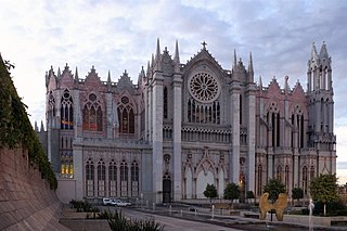
Morelia is a city and municipal seat of the municipality of Morelia in the north-central part of the state of Michoacán in central Mexico. It is both the most populous and most densely populated municipality in Michoacán. The city is in the Guayangareo Valley and is the capital and largest city of the state. The main pre-Hispanic cultures here were the Purépecha and the Matlatzinca, but no major cities were founded in the valley during this time. The Spanish took control of the area in the 1520s. The Spanish under Viceroy Antonio de Mendoza founded a settlement here in 1541 with the name of Valladolid, which became rival to the nearby city of Pátzcuaro for dominance in Michoacán. In 1580, this rivalry ended in Valladolid's favor, and it became the capital of the viceregal province. After the Mexican War of Independence, the city was renamed Morelia in honor of José María Morelos, who hailed from the city. In 1991, the city was declared a UNESCO World Heritage Site for its well-preserved historical buildings and layout of the historic center. It is tradition to name people born on September 30 after the city.

<span class="mw-page-title-main">State of Mexico</span> State of central Mexico

The State of Mexico, officially just Mexico, is one of the 32 federal entities of Mexico. Commonly known as Edomex, to distinguish it from the name of the whole country, it is the most populous state and the second most densely populated.

<span class="mw-page-title-main">Colima</span> State of Mexico

Colima, officially the Free and Sovereign State of Colima, is among the 31 states that make up the 32 Federal Entities of Mexico. It shares its name with its capital and main city, Colima.

<span class="mw-page-title-main">Guanajuato</span> State of Mexico

Guanajuato, officially the Free and Sovereign State of Guanajuato, is one of the 32 states that make up the Federal Entities of Mexico. It is divided into 46 municipalities and its capital city is Guanajuato.

<span class="mw-page-title-main">Uruapan</span> City in Michoacán, Mexico

Uruapan is the second largest city in the Mexican state of Michoacán. It is located at the western edge of the Purépecha highlands, just to the east of the Tierra Caliente region. Since the colonial period, it has been an important city economically due its location. The city was conquered by the Spanish in 1522, when the last Purépecha ruler fled the Pátzcuaro area to here. The modern city was laid out in 1534 by Friar Juan de San Miguel. It played an important role in the War of Independence, and was the capital of Michoacán during the French Intervention. Today it is the center of Mexico's avocado growing region, with most of the crop distributed from here nationally and internationally.

<span class="mw-page-title-main">Ciudad Hidalgo, Michoacán</span> City in Michoacán, Mexico

Ciudad Hidalgo, or simply Hidalgo, is a city and municipal seat of the Municipality of Hidalgo in the far northeast of the state of Michoacán, Mexico. It is a city located in a rural, mountainous area. While most of the city consists of modern buildings, its principal monument is the 16th-century church and former monastery of San José. Formerly, its name was Taximaroa, and it was the part of the Purépecha Empire closest to the Aztec Empire. This prompted two unsuccessful Aztec invasions as well as the first Spanish incursion into Purépecha lands in 1522. For both the city and rural communities around it, forestry and furniture making are important parts of the economy, but deforestation is forcing the area to look into alternatives such as tourism to take advantage of its natural resources and cultural sites.

<span class="mw-page-title-main">Bajío</span> Region in Central Mexico

The Bajío is a cultural and geographical region within the central Mexican plateau which roughly spans from northwest of Mexico City to the main silver mines in the northern-central part of the country. This includes the states of Querétaro, Guanajuato, parts of Jalisco, Aguascalientes and parts of Zacatecas, San Luis Potosí and Michoacán.

Nuevo Urecho is a municipality located in the center of the Mexican state of Michoacán. The municipality has an area of 330.66 square kilometres and is bordered to the north by the municipality of Taretan, to the east by Ario, to the south by La Huacana, and to the west by Gabriel Zamora. The municipality had a population of 7,722 inhabitants according to the 2005 census. Its municipal seat is the city of the same name.

<span class="mw-page-title-main">Irapuato</span> City and municipality in Guanajuato, Mexico

Irapuato is a Mexican city and municipality located at the foot of the Arandas Hill, in the central region of the state of Guanajuato. It lies between the Silao River and the Guanajuato River, a tributary of the Lerma River, at 1,724 m (5,656 ft) above sea level. It is located at 20°40′N101°21′W. The city is the second-largest in the state, with a population of 342,561 according to the 2005 census, while its municipality has a population of 529,440. The municipality has an area of 851 km2 (329 sq mi) and includes numerous smaller outlying communities. Although it is now an important center for regional trade and transportation center as well the site of several automotive and chemical manufacturing plants, the city's main industry has historically been agriculture and it has long been known for its strawberries and industry of refried beans, also the raising of pigs and cattle. The fruits and flowers of Irapuato's luxurious gardens are well known throughout Mexico.

<span class="mw-page-title-main">Santa Clara del Cobre</span> Town and Municipality in Michoacán, Mexico

Santa Clara del Cobre is a Magical town and municipality located in the center of the state of Michoacán, Mexico, 18 km from Pátzcuaro and 79 km from the state capital of Morelia. While the official name of the municipality is Salvador Escalante, and the town is often marked as "Villa Escalante" or "Salvador Escalante" on maps, both entities are interchangeably called Santa Clara del Cobre. The town is part of the Pátzcuaro region of Michoacán, and ethnically dominated by the Purépecha people. These people have been working with copper since the pre-Hispanic era, and led to this town's dominance in copper crafts over the colonial period (1519–1821) until well into the 19th century. Economic reverses led to the industry's near-demise here until efforts in the 1940s and 1970s managed to bring the town's work back into prominence.

<span class="mw-page-title-main">Tlalpujahua</span> Town and Municipality in Michoacán, Mexico

Tlalpujahua is a town and municipality located in the far northeast of the state of Michoacán in central Mexico. It is a former mining town, home of the Dos Estrellas Mine, which was the leading producer of gold in the early 20th century. A major landslide of mud and mining debris damaged this mine and buried about one-third of the town in 1937. Mining continued until 1959, but nationalization of the mine by President Cardenas in the 1930s led to the demise of the mine and impoverishment of the town. In the 1960s, a local by the name of Joaquín Muñoz Orta began making Christmas tree ornaments here. This eventually grew into what is now one of the largest producers of ornaments called Adornos Navideños SA de CV. In addition to this and another factory, there are about 150 small workshops dedicated to making Christmas items, with about 70% of the town's economy based on it.

<span class="mw-page-title-main">Jalisco</span> State of Mexico

Jalisco, officially the Free and Sovereign State of Jalisco, is one of the 31 states which, along with Mexico City, comprise the 32 Federal Entities of Mexico. It is located in western Mexico and is bordered by six states, Nayarit, Zacatecas, Aguascalientes, Guanajuato, Michoacán, and Colima. Jalisco is divided into 125 municipalities, and its capital and largest city is Guadalajara.

<span class="mw-page-title-main">Ihuatzio (archaeological site)</span> Archaeological site in Michoacán, Mexico

Ihuatzio is an archaeological site in Michoacán state, Mexico. It is at the southern slopes of Cerro Tariaqueri, just north of the Ihuatzio town, in the Tzintzuntzan municipality.

<span class="mw-page-title-main">Lago de Camécuaro National Park</span> Park in Michoacán, Mexico

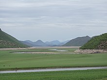
Lago de Camécuaro National Park is located east of the city of Zamora de Hidalgo in the municipality of Tangancícuaro in the state of Michoacán. The park consists of 9.65 hectares of protected area including Camécuaro Lake which is supplied by a series of natural springs. The lake is popular due to its clear water and the vegetation that surrounds the lake. Even though the lake is relatively small, many photographers from all over Mexico come to take photographs of the park's views.

<span class="mw-page-title-main">Handcrafts and folk art in Michoacán</span> Folk art

Michoacán handcrafts and folk art is a Mexican regional tradition centered in the state of Michoacán, in central/western Mexico. Its origins traced back to the Purépecha Empire, and later to the efforts to organize and promote trades and crafts by Vasco de Quiroga in what is now the north and northeast of the state. The state has a wide variety of over thirty crafts, with the most important being the working of wood, ceramics, and textiles. A number are more particular to the state, such as the creation of religious images from corn stalk paste, and a type of mosaic made from dyed wheat straw on a waxed board. Though there is support for artisans in the way of contests, fairs, and collective trademarks for certain wares, Michoacán handcrafts lack access to markets, especially those catering to tourists.

<span class="mw-page-title-main">Jose Corona Nuñez</span>

José Corona Núñez was a Mexican author, anthropologist, and history professor who discovered several important archeological sites throughout México. His main body of work revolved around his native state of Michoacán, and in particular the Tarascan or Purépecha culture.

<span class="mw-page-title-main">Queréndaro</span> Municipality of Michoacán, Mexico

Queréndaro is a municipality in the Mexican state of Michoacán. The word Queréndaro is of Chichimeca origin and means "place of rocks", from the great rock in the municipality known as "La Peña Rajada". It contains a cave with paintings that date from the pre-Hispanic era.

<span class="mw-page-title-main">Zinapécuaro</span> Municipality in Michoacán, Mexico

Zinapécuaro is a municipality in the Mexican state of Michoacán, located 50 kilometres (31 mi) northeast of the state capital Morelia.

<span class="mw-page-title-main">Senguio</span> Municipality in Michoacán, Mexico

Senguio is a municipality in the Mexican state of Michoacán. It is located approximately 90 kilometres (56 mi) east of the state capital of Morelia.

References

  1. 1 2 Instituto Nacional de Estadística y Geografía (INEGI). "Censo de Población y Vivienda 2010" . Retrieved 2011-03-03.
  2. "El Estado de Michoacán Epoca Prehispanica" [The State of Michoacan Pre-Hispanic Era] (in Spanish). Morelia, Michoacán: UMSNH. Retrieved June 16, 2010.
  3. Instituto Nacional de Ecología. "Parque Nacion l Lago de Camécuaro" . Retrieved 2011-03-03.
  4. "Normales climatológicas 1951-2010" (in Spanish). Servicio Meteorológico Nacional. Retrieved 6 May 2015.
  5. "Normales climatológicas 1981-2000" (PDF) (in Spanish). Comision Nacional Del Agua. Retrieved 6 May 2015.
  6. "Station 76662 Zamora". Global station data 1961–1990—Sunshine Duration. Deutscher Wetterdienst. Archived from the original on 2017-10-17. Retrieved 6 May 2015.
  7. "Santuario Diocesano de Nuestra Señora de Guadalupe Datos del Santuario". www.santuarioguadalupano.org.mx. Retrieved 2016-06-15.

Francisco Orozoc, MSW. University of Southern California & Ph.D Candidate from UCI.

Notes

  1. Station ID for Zamora is 76662 Use this station ID to locate the sunshine duration