
Invercargill is the southernmost and westernmost city in New Zealand, and one of the southernmost cities in the world. It is the commercial centre of the Southland region. The city lies in the heart of the wide expanse of the Southland Plains to the east of the Ōreti or New River some 18 km north of Bluff, which is the southernmost town in the South Island. It sits amid rich farmland that is bordered by large areas of conservation land and marine reserves, including Fiordland National Park covering the south-west corner of the South Island and the Catlins coastal region.

Riverton, officially Riverton / Aparima, is a small New Zealand town 30 kilometres (19 mi) west of Invercargill, on the south-eastern shorelines of the Jacobs River Estuary. The estuary is formed by the Aparima and Pourakino rivers, leading through a narrow outflow channel into Foveaux Strait. Accessible via State Highway 99 on the Southern Scenic Route, the main part of the town is on flat land and the northern end of Oreti Beach. South Riverton is built on the hills between the eastern shore of the estuary and Taramea Bay.

The Mataura River is in the Southland Region of the South Island of New Zealand. It is 240 kilometres (150 mi) long.
Winton is a rural town in Southland, New Zealand. It is located close to the east bank of the Ōreti River, 30 kilometres north of Invercargill and 50 kilometres south of Lumsden. The town is named after Thomas Winton, a local stockman who lived and farmed in the area in the 1850s. The district thrived with the development of sheep and fat-lamb farms in the early 1900s. Later, dairy farming became the staple economy, although the town has also seen sawmills, and flax and linen-flax industries.

Southland District is a New Zealand territorial authority district that covers most of the southern end of the South Island as well as Stewart Island.
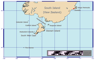
Foveaux Strait is a strait that separates Stewart Island from the South Island of New Zealand. The width of the strait ranges from about 23 to 53 km, and the depth varies between 18 and 46 m. The strait was first charted by an American sealer, Owen Folger Smith. He charted the strait from a whaleboat of the sealing brig Union in 1804.

Lumsden is a town in Southland, New Zealand. Lying in a gap in the surrounding hills, Lumsden is the location of a major junction on State Highway 6. Lumsden is 81 kilometres north of Invercargill, 106 kilometres south of Queenstown, 59 kilometres west of Gore and 77 kilometres east of Te Anau. The Ōreti River is located 1.5 kilometres east of the town.
The Southland Plains is a general name given to several areas of low-lying land in the South Island of New Zealand, separated by the rise of the Hokonui Hills in the north. It forms a sizeable area of Southland region and encompasses its two principal settlements the city of Invercargill and the town of Gore. The Southland Plains include some of New Zealand's most fertile farmland.

Oreti Beach is the central bay of three lying on the Foveaux Strait coast of Southland, New Zealand, the others being Te Waewae Bay and Toetoes Bay. Twenty-six kilometres in length, the bay lies between the town of Riverton and the outflow of the Aparima River in the northwest, and the estuary of the Ōreti River in the southeast.
The Aparima River, earlier known as Jacob's River, is one of the southward-flowing braided rivers of Southland, New Zealand.
Dipton is a small town in the Southland region of New Zealand. It is located 20 kilometres south of Lumsden and 60 kilometres north of Invercargill. From 20 October 1875 until its closure on 13 December 1982, Dipton was situated on the Kingston Branch railway.
The following lists events that happened during 1967 in New Zealand.

Invercargill Airport is a fully secured controlled international designated airport located 1.6 km west of the Central business district of Invercargill at the bottom of the South Island of New Zealand. It is the southernmost controlled airport in the Commonwealth. Formed on land reclaimed from the Waihopai/New River Estuary in 1938, the airport was prone to flooding, notably in 1984 when it was inoperable for two months. The Invercargill City Council considered moving the airport back to Dawson Farm, Myross Bush, the original site up to 1942. Instead, a large flood protection scheme was built, but during its construction heavy rain and an unusually high tidal surge flooded it again in 1987. There have been no problems since. The airport has a main secured terminal, a backup international secured terminal and 5 tarmac gates. Invercargill is the eleventh-busiest airport in New Zealand by passenger traffic.

State Highway 6 is a major New Zealand state highway. It extends from the Marlborough region in the northeastern corner of the South Island across the top of the island, then down the length of the island, initially along the West Coast and then across the Southern Alps through inland Otago and finally across the Southland Plains to the island's south coast. Distances are measured from north to south.

The Mararoa River is one of the braided rivers of the Southland Region of the South Island of New Zealand.
The Around the Mountains Cycle Trail is a cycle trail set in the remote wilderness of southern New Zealand. 186 km in length, it can be ridden in either direction, starting at Kingston or Walter Peak and taking three to five days at a relaxed pace to complete. The Around the Mountains Cycle Trail is recognised as one of New Zealand's 23 Great Rides.

Lake Ngaroto is a peat lake in Waipa District of New Zealand.

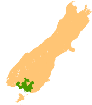
Southland is New Zealand's southernmost region. It consists of the southwestern portion of the South Island and includes Stewart Island. Southland is bordered by the culturally similar Otago Region to the north and east, and the West Coast Region in the extreme northwest. The region covers over 3.1 million hectares and spans 3,613 km of coastline. As of June 2023, Southland has a population of 103,900, making it the eleventh-most-populous New Zealand region, and the second-most sparsely populated. Approximately half of the region's population lives in Invercargill, Southland's only city.
The Invercargill Rowing Club is a New Zealand rowing club.
Otatara is an outer suburb of New Zealand's southernmost city, Invercargill. It is surrounded by the Ōreti River to the west and south, and its estuary and Invercargill Airport to the east, and West Plains to the north. Historically, it was in Southland County before it was abolished.

