
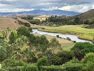
The Waipā River is in the Waikato region of the North Island of New Zealand. The headwaters are in the Rangitoto Range east of Te Kūiti. It flows north for 115 kilometres (71 mi), passing through Ōtorohanga and Pirongia, before flowing into the Waikato River at Ngāruawāhia. It is the Waikato's largest tributary. The Waipā's main tributary is the Puniu River.
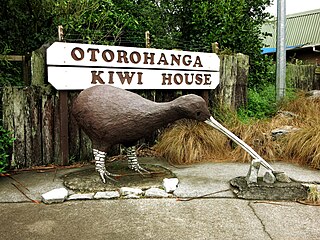
Ōtorohanga is a north King Country town in the Waikato region in the North Island of New Zealand. It is located 53 kilometres (33 mi) south of Hamilton and 18 kilometres (11 mi) north of Te Kūiti, on the Waipā River. It is a service town for the surrounding dairy-farming district. It is recognised as the "gateway" to the Waitomo Caves and as the "Kiwiana Town" of New Zealand. Until 2007, Ōtorohanga held a yearly 'Kiwiana Festival.'
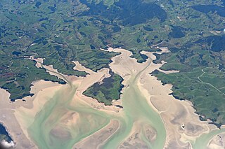
Kawhia Harbour is one of three large natural inlets in the Tasman Sea coast of the Waikato region of New Zealand's North Island. It is located to the south of Raglan Harbour, Ruapuke and Aotea Harbour, 40 kilometres southwest of Hamilton. Kawhia is part of the Ōtorohanga District and is in the King Country. It has a high-tide area of 68 km2 (26 sq mi) and a low-tide area of 18 km2 (6.9 sq mi). Te Motu Island is located in the harbour.
The King Country is a region of the western North Island of New Zealand. It extends approximately from Kawhia Harbour and the town of Ōtorohanga in the north to the upper reaches of the Whanganui River in the south, and from the Hauhungaroa and Rangitoto Ranges in the east to near the Tasman Sea in the west. It comprises hill country, large parts of which are forested.
Taupō District Council is a territorial authority that administers the Taupō District in the Central North Island of New Zealand. The district stretches from the small town of Mangakino in the northwest to the Tongariro National Park in the south, and east into the Kaingaroa Forest, covering 6,970 km2. It had a population of as of June 2023.

South Waikato District Council is the territorial authority for the South Waikato District of New Zealand.
Southland District Council is the territorial authority for the Southland District of New Zealand.

Gore District Council is the territorial authority for the Gore District of New Zealand.
The Ōpārau River is a river of the Waikato Region of New Zealand's North Island in the area occupied by Ngāti Hikairo. It flows southwest from its sources in the Pirongia Forest Park, the highest being The Cone, and flows into the Kawhia Harbour, 5 kilometres (3 mi) east of Kawhia. The river has about 171 km (106 mi) of tributaries.

Waipā District Council is the territorial authority for the Waipā District of New Zealand.
Waimakariri District Council is the territorial authority for the Waimakariri District of New Zealand.

Ōtorohanga District is a territorial municipality in the King Country area and Waikato region of the North Island of New Zealand. It is a mostly rural area, with Ōtorohanga town being by far the biggest urban area, with a population nearing 3,000. The District was called Otorohanga County from 1971 to 1979.
Gisborne District Council is the unitary authority for the Gisborne District of New Zealand. The council consists of a mayor and 13 ward councillors. The district consists of the city of Gisborne and a largely rural region on the east coast of the North Island.

Waikato District Council is the territorial authority for the Waikato District of New Zealand.
Mackenzie District Council is the territorial authority for the Mackenzie District of New Zealand.

Ruapehu District Council is the territorial authority for the Ruapehu District of New Zealand.

Waitomo District Council is the territorial authority for the Waitomo District of New Zealand.
The Mayor of Ōtorohanga officiates over the Ōtorohanga District of New Zealand's North Island. The County of Otorohanga was established in 1971, becoming a district council in 1979.
Queenstown-Lakes District Council is the territorial authority for the Queenstown-Lakes District of New Zealand.

Thames-Coromandel District Council is the territorial authority for the Thames-Coromandel District of New Zealand. The council consists of the mayor of Thames-Coromandel and 8 ward councillors. There are also five community boards.