Žigrski Vrh

Last updated
Žigrski Vrh
Slovenia location map.svg
Red pog.svg
Žigrski Vrh
Location in Slovenia
Coordinates: 46°0′36.82″N15°21′28.61″E / 46.0102278°N 15.3579472°E / 46.0102278; 15.3579472 Coordinates: 46°0′36.82″N15°21′28.61″E / 46.0102278°N 15.3579472°E / 46.0102278; 15.3579472
Country Flag of Slovenia.svg Slovenia
Traditional region Styria
Statistical region Lower Sava
Municipality Sevnica
Area
  Total 2.65 km2 (1.02 sq mi)
Elevation 305.1 m (1,001.0 ft)
Population (2002)
  Total 171
[1]

Žigrski Vrh (pronounced  [ˈʒiːɡəɾski ˈʋəɾx] ) is a settlement in the Municipality of Sevnica in central Slovenia. It lies in the hills above the left bank of the Sava River east of Sevnica in the historical region of Styria. The municipality is now included in the Lower Sava Statistical Region. [2]

Municipality of Sevnica Municipality in Slovenia

The Municipality of Sevnica is a municipality along the Sava and the Mirna Rivers in southeastern Slovenia. The seat of the municipality is the town of Sevnica. Today it is part of the Lower Sava Statistical Region. It is the 12th-largest municipality by area in Slovenia.

Slovenia republic in Central Europe

Slovenia, officially the Republic of Slovenia, is a sovereign state located in southern Central Europe at a crossroads of important European cultural and trade routes. It is bordered by Italy to the west, Austria to the north, Hungary to the northeast, Croatia to the southeast, and the Adriatic Sea to the southwest. It covers 20,273 square kilometers (7,827 sq mi) and has a population of 2.07 million. One of the successor states of the former Yugoslavia, Slovenia is a parliamentary republic and a member of the United Nations, of the European Union, and of NATO. The capital and largest city is Ljubljana.

Sava river in Southeast Europe

The Sava is a river in Central and Southeastern Europe, a right tributary of the Danube. It flows through Slovenia, Croatia, along the northern border of Bosnia and Herzegovina, and through Serbia, discharging into the Danube in Belgrade. Its central part is a natural border of Bosnia-Herzegovina and Croatia. The Sava forms the northern border of the Balkan Peninsula, and the southern edge of the Pannonian Plain.

The local church is dedicated to Saint Benedict and belongs to the Parish of Sevnica. It dates to the 16th century and was remodelled around 1700 in the Baroque style. [3]

Church (building) building constructed for Christian worship

A church building or church house, often simply called a church, is a building used for Christian religious activities, particularly for Christian worship services. The term is often used by Christians to refer to the physical buildings where they worship, but it is sometimes used to refer to buildings of other religions. In traditional Christian architecture, the church is often arranged in the shape of a Christian cross. When viewed from plan view the longest part of a cross is represented by the aisle and the junction of the cross is located at the altar area.

Benedict of Nursia Christian saint and monk

Benedict of Nursia is a Christian saint, who is venerated in the Roman Catholic Church, the Eastern Orthodox Church, the Oriental Orthodox Churches, the Anglican Communion and Old Catholic Churches. He is a patron saint of Europe.
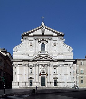
Baroque architecture building style of the Baroque era

Baroque architecture is the building style of the Baroque era, begun in late 16th-century Italy, that took the Roman vocabulary of Renaissance architecture and used it in a new rhetorical and theatrical fashion, often to express the triumph of the Catholic Church. It was characterized ..by new explorations of form, light and shadow, and dramatic intensity. Common features of Baroque architecture included gigantism of proportions; a large open central space where everyone could see the altar; twisting columns, theatrical effects, including light coming from a cupola above; dramatic interior effects created with bronze and gilding; clusters of sculpted angels and other figures high overhead; and an extensive use of trompe-l'oeil, also called "quadratura," with painted architectural details and figures on the walls and ceiling, to increase the dramatic and theatrical effect.

Related Research Articles

Brezovo, Sevnica in Styria, Slovenia

Brezovo is a small settlement in the Sava Hills in the Municipality of Sevnica in central Slovenia. The area is part of the historical region of Styria. The municipality is now included in the Lower Sava Statistical Region.

Cerovec, Sevnica in Styria, Slovenia

Cerovec is a dispersed settlement in the hills northeast of Šentjanž in the Municipality of Sevnica in central Slovenia. The area is part of the historical region of Styria. The municipality is now included in the Lower Sava Statistical Region. The settlement includes the hamlets of Podglina, Trebelno, Bajnof, Grič, Lesičjek, Veliki Vrh, Hom, and Pekel.

Dolnje Brezovo in Styria, Slovenia

Dolnje Brezovo is a small village on the left bank of the Sava River in the Municipality of Sevnica in central Slovenia. The area is part of the historical region of Lower Styria. The municipality is now included in the Lower Sava Statistical Region.

Gornje Brezovo in Styria, Slovenia

Gornje Brezovo is a settlement in the Municipality of Sevnica in central Slovenia. It lies on the left bank of the Sava River east of Sevnica. The area is part of the historical region of Styria. The municipality is now included in the Lower Sava Statistical Region.

Jeperjek in Lower Carniola, Slovenia

Jeperjek is a small settlement in the hills southwest of Boštanj in the Municipality of Sevnica in central Slovenia. The part of the municipality on the right bank of the Sava River was traditionally part of the traditional region of Lower Carniola. The entire municipality is now included in the Lower Sava Statistical Region.

Kamenica, Sevnica in Lower Carniola, Slovenia

Kamenica is a small village northeast of Krmelj in the Municipality of Sevnica in central Slovenia. The area is part of the historical region of Lower Carniola. The municipality is now included in the Lower Sava Statistical Region. Until 2001, the settlement included the area of now autonomous settlement of Kamenško.

Krsinji Vrh in Lower Carniola, Slovenia

Krsinji Vrh is a small settlement in the Municipality of Sevnica in central Slovenia. It lies in the hills east of Mokronog in the historical region of Lower Carniola. The Municipality of Sevnica is now included in the Lower Sava Statistical Region.

Lukovec, Sevnica in Lower Carniola, Slovenia

Lukovec is a small settlement in the Municipality of Sevnica in east-central Slovenia. It lies above the right bank of the Sava River east of Boštanj. The area is part of the historical region of Lower Carniola. The municipality is now included in the Lower Sava Statistical Region.

Malkovec in Lower Carniola, Slovenia

Malkovec is a viticultural settlement along the road on the ridge of Malkovec Hill, southeast of Tržišče, in the Municipality of Sevnica in the Sava region of Slovenia. The municipality is included in the Lower Sava Statistical Region. The area is part of the traditional region of Lower Carniola.

Metni Vrh in Styria, Slovenia

Metni Vrh is a dispersed settlement in the hills north of Sevnica in east-central Slovenia. The area is part of the historical region of Lower Styria. The Municipality of Sevnica is now included in the Lower Sava Statistical Region.

Mrzla Planina in Styria, Slovenia

Mrzla Planina is a dispersed settlement in the hills northeast of Sevnica in east-central Slovenia. The area is part of the historical region of Styria. The municipality is now included in the Lower Sava Statistical Region.

Orehovo in Styria, Slovenia

Orehovo is a settlement in the Municipality of Sevnica in central Slovenia. It lies on the left bank of the Sava River northwest of Sevnica. The area was traditionally part of Lower Styria. The municipality is now included in the Lower Sava Statistical Region.

Podgorica, Sevnica in Styria, Slovenia

Podgorica is a dispersed settlement in the Municipality of Sevnica in east-central Slovenia. It lies on the slope of Mount Lisca north of Sevnica in the historical region of Styria. The municipality is now included in the Lower Sava Statistical Region.

Radež in Styria, Slovenia

Radež is a settlement in the hills above the left bank of the Sava River in the Municipality of Sevnica in east central Slovenia. The area is part of the historical region of Styria. The municipality is now included in the Lower Sava Statistical Region.

Račica, Sevnica in Styria, Slovenia

Račica is a settlement east of Loka pri Zidanem Mostu on the left bank of the Sava River in the Municipality of Sevnica in east-central Slovenia. The area is part of the historical region of Styria. The municipality is now included in the Lower Sava Statistical Region.

Slančji Vrh in Lower Carniola, Slovenia

Slančji Vrh is a small nucleated village in the Municipality of Sevnica in east-central Slovenia. The area is part of the historical region of Lower Carniola. The municipality is now included in the Lower Sava Statistical Region.

Vrh pri Boštanju Place in Lower Carniola, Slovenia

Vrh pri Boštanju is a settlement in the hills southwest of Boštanj in the Municipality of Sevnica in east-central Slovenia. The area is part of the historical region of Lower Carniola. The municipality is now included in the Lower Sava Statistical Region. The settlement includes the hamlets of Dule, Pleček, Gabrnik, Ravne, Topolovec, Grič, Hrib, Dobje, Reviše, Volčje Jame, Drče, Okič, Sleme, Drenovec, Straški Hrib, and Lipoglav.

Vranje, Sevnica in Styria, Slovenia

Vranje is a settlement in the Municipality of Sevnica in central Slovenia. It lies in the hills northeast of Sevnica in the historical region of Styria. The municipality is now included in the Lower Sava Statistical Region.

Municipality of Škocjan Municipality in Slovenia

The Municipality of Škocjan, established in October 1994, is a municipality in the traditional region of Lower Carniola in southeastern Slovenia. The seat of the municipality is Škocjan. The Municipality of Škocjan is now included in the Southeast Slovenia Statistical Region. The majority of the municipality is part of the Novo Mesto Administrative Unit, except for the northeastern part, which belongs to the Sevnica Administrative Unit.

References

  1. Statistical Office of the Republic of Slovenia
  2. Sevnica municipal site
  3. "EŠD 3354". Registry of Immovable Cultural Heritage (in Slovenian). Ministry of Culture of the Republic of Slovenia. Retrieved 20 October 2011.