Abbottstown, Pennsylvania

Last updated

Abbottstown, Pennsylvania
Borough
Abbottstown, Pennsylvania, U.S. 30.jpg
U.S. Route 30 in Abbottstown
Seal of Abbottstown, Pennsylvania.png
Adams County Pennsylvania incorporated and unincorporated areas Abbottstown highlighted.svg
Location in Adams County and the U.S. state of Pennsylvania.
USA Pennsylvania location map.svg
Red pog.svg
Abbottstown
Location in Pennsylvania and the United States
Usa edcp location map.svg
Red pog.svg
Abbottstown
Abbottstown (the United States)
North America laea location map.svg
Red pog.svg
Abbottstown
Abbottstown (North America)
Coordinates: 39°53′08″N76°59′10″W / 39.88556°N 76.98611°W / 39.88556; -76.98611
Country United States
State Pennsylvania
County Adams
Settled1753
Incorporated1835
Government
  TypeBorough Council
Area
[1]
  Total0.55 sq mi (1.43 km2)
  Land0.55 sq mi (1.41 km2)
  Water0.01 sq mi (0.02 km2)
Elevation
564 ft (172 m)
Population
 (2020) [2]
  Total1,022
  Density1,871.79/sq mi (722.71/km2)
Time zone UTC-5 (Eastern (EST))
  Summer (DST) UTC-4 (EDT)
Zip Code
17301
Area code 717
FIPS code 42-00116
Website www.abbottstownborough.com

Abbottstown is a borough in Adams County, Pennsylvania, United States. The population was 1,022 at the 2020 census. [3]

Contents

History

Abbottstown is named for John Abbott, who founded it in 1753. [4] The John Abbott House was added to the National Register of Historic Places in 1980. [5] The town had rail service via the East Berlin Railroad from 1877 to 1914 and 1916 to 1939. The tracks were removed in 1940. [6]

In 1950, Abbottstown had a population of 538. [7]

Geography

Abbottstown is located at 39°53′8″N76°59′10″W / 39.88556°N 76.98611°W / 39.88556; -76.98611 (39.885621, -76.986120). [8] According to the U.S. Census Bureau, the borough has a total area of 0.6 square miles (1.6 km2), all land.

Demographics

Historical population
CensusPop.Note
1850 334
1870 325
1880 36813.2%
1890 3813.5%
1900 345−9.4%
1910 332−3.8%
1920 3340.6%
1930 45736.8%
1940 441−3.5%
1950 53822.0%
1960 5614.3%
1970 552−1.6%
1980 5581.1%
1990 539−3.4%
2000 90567.9%
2010 1,01111.7%
2020 1,0221.1%
Sources: [9] [10] [2]

As of the census [11] of 2000, there were 905 people, 323 households, and 254 families residing in the borough. The population density was 1,592.2 inhabitants per square mile (614.8/km2). There were 346 housing units at an average density of 608.7 per square mile (235.0/km2). The racial makeup of the borough was 95.25% White, 0.22% African American, 0.11% Native American, 0.11% Pacific Islander, 3.87% from other races, and 0.44% from two or more races. Hispanic or Latino of any race were 5.52% of the population.

There were 323 households, out of which 43.7% had children under the age of 18 living with them, 64.4% were married couples living together, 10.2% had a female householder with no husband present, and 21.1% were non-families. 15.5% of all households were made up of individuals, and 6.8% had someone living alone who was 65 years of age or older. The average household size was 2.80 and the average family size was 3.15.

In the borough the population is spread out over several age groups, with 29.5% under the age of 18, 7.6% from 18 to 24, 36.4% from 25 to 44, 18.7% from 45 to 64, and 7.8% who were 65 years of age or older. The median age was 32 years. For every 100 females there were 92.1 males. For every 100 females age 18 and over, there were 91.6 males.

The median income for a household in the borough was $49,063, and the median income for a family was $52,578. Males had a median income of $31,736 versus $24,083 for females. The per capita income for the borough was $17,246. About 1.6% of families and 2.4% of the population were below the poverty line, including 0.8% of those under age 18 and 1.7% of those age 65 or over.

In 2010 Abbottstown had a population of 1,011. The racial and ethnic composition of the population was 88.4% non-Hispanic white, 1.4% black or African American, 0.1% Native American, 1.0% Asian, 1.2% reporting two or more races and 9.4% Hispanic or Latino. [12]

Notable person

Related Research Articles

<span class="mw-page-title-main">East Berlin, Pennsylvania</span> Borough in Pennsylvania, United States

East Berlin is a borough in Adams County, Pennsylvania, United States. The population was 1,542 at the 2020 census.

<span class="mw-page-title-main">Hamilton Township, Adams County, Pennsylvania</span> Township in Pennsylvania, United States

Hamilton Township is a township in Adams County, Pennsylvania, United States. The population was 2,714 at the 2020 census.

<span class="mw-page-title-main">Conyngham Township, Columbia County, Pennsylvania</span> Township in Pennsylvania, United States

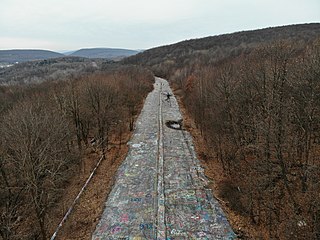
Conyngham Township is a township in Columbia County, Pennsylvania, United States. It is part of Northeastern Pennsylvania. The population was 689 at the 2020 census. Conyngham Township surrounds the famous borough of Centralia, and part of the mine fire is located here. The abandoned town of Byrnesville is located here.

<span class="mw-page-title-main">New Cumberland, Pennsylvania</span> Borough in Pennsylvania, United States

New Cumberland is a borough in easternmost Cumberland County, Pennsylvania, United States. New Cumberland was incorporated on March 21, 1831. The population was 7,507 at the 2020 census. The borough is noted for its historic downtown which includes landmarks like the historic West Shore Theater, Borough Park and the yearly Apple Festival, which gathers hundreds of vendors and thousands of visitors.

<span class="mw-page-title-main">Wormleysburg, Pennsylvania</span> Borough in Pennsylvania, United States

Wormleysburg is a borough in Cumberland County, Pennsylvania, United States. The population was 3,070 at the 2010 census. It is part of the Harrisburg–Carlisle Metropolitan Statistical Area.

<span class="mw-page-title-main">Elizabethville, Pennsylvania</span> Borough in Pennsylvania, United States

Elizabethville is a borough in Dauphin County, Pennsylvania, United States. As of the 2020 census, the borough's population was 1,352. It is part of the Harrisburg metropolitan area.

<span class="mw-page-title-main">Williamstown, Pennsylvania</span> Borough in Pennsylvania, United States

Williamstown is a borough in Dauphin County, Pennsylvania, United States. The borough is 38 miles (61 km) northeast of Harrisburg. Formerly, anthracite coal mines and hosiery mills were located in the borough. The population was 1,303 at the 2020 census.

<span class="mw-page-title-main">Parkside, Pennsylvania</span> Borough in Pennsylvania, United States

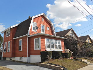
Parkside is a borough in Delaware County, Pennsylvania, United States. The population was 2,328 at the 2010 census.

<span class="mw-page-title-main">Cleona, Pennsylvania</span> Borough in Pennsylvania, United States

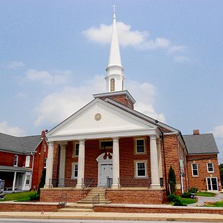
Cleona is a borough in Lebanon County, Pennsylvania, United States. It is part of the Lebanon, Pennsylvania Metropolitan Statistical Area. The population was 2,005 at the 2020 census.

<span class="mw-page-title-main">Jonestown, Lebanon County, Pennsylvania</span> Borough in Pennsylvania, United States

Jonestown, previously known as Williamsburg, is a borough in Lebanon County, Pennsylvania, United States. It is part of the Lebanon metropolitan statistical area. The population was 1,629 at the 2020 census.

<span class="mw-page-title-main">Harveys Lake, Pennsylvania</span> Borough in Pennsylvania, United States

Harveys Lake is a borough in Luzerne County, Pennsylvania, United States. It is part of the Back Mountain, a 118 square miles (310 km2) region in northern Luzerne County.

<span class="mw-page-title-main">Cross Roads, Pennsylvania</span> Borough in Pennsylvania, United States

Cross Roads is a borough in York County, Pennsylvania, United States. The population was 524 at the 2020 census. It is part of the York–Hanover metropolitan area. The crossroads in the borough is where Church Road intersects Cross Roads Avenue and is joined by Century Farms Road.

<span class="mw-page-title-main">Fawn Grove, Pennsylvania</span> Borough in Pennsylvania, United States

Fawn Grove is a borough in York County, Pennsylvania, United States. The population was 476 at the 2020 census. It is part of the York–Hanover metropolitan area. It is served by the South Eastern School District, which provides public education.

<span class="mw-page-title-main">Lower Windsor Township, Pennsylvania</span> Township in Pennsylvania, United States

Lower Windsor Township is a township in York County, Pennsylvania, United States. The population was 7,511 at the 2020 census. Samuel S. Lewis State Park overlooks the Susquehanna River in the eastern part of the township.

<span class="mw-page-title-main">Manchester, Pennsylvania</span> Borough in Pennsylvania, United States

Manchester is a borough in York County, Pennsylvania, United States. The population was 2,798 at the 2020 census. It is part of the York–Hanover metropolitan area.

<span class="mw-page-title-main">North Codorus Township, Pennsylvania</span> Township in Pennsylvania, United States

North Codorus Township is a township in York County, Pennsylvania, United States. The population was 9,149 at the 2020 census.

<span class="mw-page-title-main">North York, Pennsylvania</span> Borough in Pennsylvania, United States

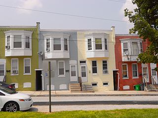
North York is a borough, adjacent to the city of York, in York County, Pennsylvania, United States. As of the 2020 census, the borough had a total population of 2,196.

<span class="mw-page-title-main">Shrewsbury, Pennsylvania</span> Borough in Pennsylvania, United States

Shrewsbury is a borough in York County, Pennsylvania, United States. The population was 3,848 at the time of the 2020 census. It is part of the York–Hanover metropolitan area.

<span class="mw-page-title-main">Springfield Township, York County, Pennsylvania</span> Township in Pennsylvania, United States

Springfield Township is a township in York County, Pennsylvania, United States. The population was 6,023 at the 2020 census.

<span class="mw-page-title-main">York Township, Pennsylvania</span> Township in Pennsylvania, United States

York Township is a township in York County, Pennsylvania, United States. The township is a suburb of The City of York. The population was 29,737 at the 2020 census.

References

  1. "ArcGIS REST Services Directory". United States Census Bureau. Retrieved October 12, 2022.
  2. 1 2 "Census Population API". United States Census Bureau. Retrieved October 12, 2022.
  3. "Geographic Identifiers: 2010 Demographic Profile Data (G001): Abbottstown borough, Pennsylvania". U.S. Census Bureau, American Factfinder. Archived from the original on February 12, 2020. Retrieved July 16, 2013.
  4. Gannett, Henry (1905). The Origin of Certain Place Names in the United States. U.S. Government Printing Office. pp.  22.
  5. "National Register Information System". National Register of Historic Places . National Park Service. July 9, 2010.
  6. Taber, Thomas T. III (1987). Railroads of Pennsylvania Encyclopedia and Atlas. Thomas T. Taber III. p. 6. ISBN   0-9603398-5-X.
  7. Encyclopædia Britannica Atlas, 1959 Edition, p. 298.
  8. "US Gazetteer files: 2010, 2000, and 1990". United States Census Bureau. February 12, 2011. Retrieved April 23, 2011.
  9. "Census of Population and Housing: Decennial Censuses". United States Census Bureau . Retrieved March 4, 2012.
  10. "Incorporated Places and Minor Civil Divisions Datasets: Subcounty Resident Population Estimates: April 1, 2010 to July 1, 2012". Population Estimates. U.S. Census Bureau. Archived from the original on June 11, 2013. Retrieved December 11, 2013.
  11. "U.S. Census website". United States Census Bureau . Retrieved January 31, 2008.
  12. 2010 population report for Abbottstown, Pennsylvania
  13. Who Was Who in America, Historical Volume, 1607-1896. Marquis Who's Who. 1967.