Baramulla district or Varmul is one of the 20 districts in the Indian-administered union territory of Jammu and Kashmir in the disputed Kashmir region. Baramulla town is the administrative headquarters of this district. The district covered an area of 4,588 km2 (1,771 sq mi) in 2001, but it was reduced to 4,243 km2 (1,638 sq mi) at the time of 2011 census. In 2016, the district administration said that the area was 4,190 km2 (1,620 sq mi). Muslims constitute about 98% of the population.

Gulmarg, known as Gulmarag in Kashmiri, is a town, hill station, popular tourist destination, popular skiing destination and a notified area committee in the Baramulla district in the Indian union territory of Jammu and Kashmir. It is located at a distance of 31 km (19 mi) from Baramulla and 49 km (30 mi) from Srinagar. The town is situated in the Pir Panjal Range in the Western Himalayas and lies within the boundaries of Gulmarg Wildlife Sanctuary.
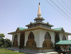
Kunzar, or Kunzer, is a town in the union territory of Jammu and Kashmir located in the District Baramulla. It is 30 km from Srinagar and approximately 32 km from Baramulla town.
Magam is a tehsil in central Kashmir's Beerwah sub-district. It is also a town, notified area committee, and a block in Budgam district in the Indian administered union territory of Jammu and Kashmir. It is 11 km (6.8 mi) away from sub-district headquarter Beerwah and 20 km (12 mi) away from Srinagar, the summer capital of Jammu and Kashmir. Magam is the top business hub in this locality, located on the way to Gulmarg. Magam comes both in baramulla district and budgam which makes this famous across these districts for business. The Idara Abu Fazal Abbas Islamic Library, opened in Magam in 1985, is the largest Islamic private library in Jammu and Kashmir.

Thanamandi is a town and a municipal committee in the Rajouri district in the Indian union territory of Jammu and Kashmir. Thanamandi lies on the Mughal Road between Rajouri and Bufliaz.
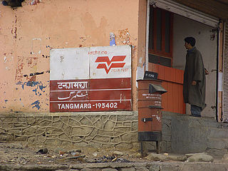
Tangmarg is a town and tehsil in Baramulla district in Indian union territory of Jammu and Kashmir. In 2014, Tangmarg was granted a sub division and trifurcated into three Tehsils, with Sub Divisional Magistrate SDM Office located at Tangmarg. The Tangmarg town is central to more than 100 villages in the vicinity. Tangmarg is gateway of gulmarg which is just 13kms away, also drung waterfall is 3kms away which makes tangmarg most crowded place in the evening due to clean & fresh environment.

Jammu and Kashmir is home to several valleys such as the Kashmir Valley, Chenab Valley, Sindh Valley and Lidder Valley. Some major tourist attractions in Jammu and Kashmir are Srinagar, with its renowned Dal Lake and Mughal Gardens, Gulmarg, Pahalgam, Bhaderwah, Patnitop and Jammu. Every year, thousands of Hindu pilgrims visit holy shrines of Vaishno Devi and Amarnath which has had a significant impact on the state's economy.

Munawar Abad, locally known as Muniwar (Munawarabad), is a town located in heart of Srinagar in the Indian union territory of Jammu and Kashmir. It is 2 km from Lal Chowk. Munawar Abad is the main link between downtown Srinagar and central Srinagar.
Hardu-Aboora is a locality in Karhama tehsil in Baramulla district in the Indian union territory of Jammu and Kashmir. It is situated on the banks of Ferozpora Nallah, at the foothills of the mountain range that runs parallel to the Srinagar-Gulmarg highway on its left side, some 15 km (9.3 mi) from Tangmarg town, Baramulla and 29 km (18 mi) from the state capital, Srinagar, and 10 km (6.2 mi) from railway station Mazhama. Under new Administrative units, Hardu Aboora was granted CD Block status, under the jurisdiction of newly carved tehsil, Karhama.
Durhama is a small village in Baramulla district in the Indian union territory of Jammu and Kashmir. It is about 20 km from district headquarters Baramulla, 13 km from the apple town Sopore and 50 km from Batmaloo, Srinagar via Putukhah- Wagoora road and 44 km via Tapper-Kreeri road. It is about 100m away from the Tehsil headquarter Wagoora and about 3.5 km from the medical block Kreeri. It is situated on the left side of the link road which connects Baramulla and Babareshi-Gulmarg. The village has three mosques and 95 households. The population of Durhama is about 698. There is a primary and a middle school in the outskirts of the village. The literacy rate of Durhama is about 67.37% as per 2011 census. A building of the block development office Wagoora is located at the entrance of Durhama. A medical sub centre is also located alongside B.D.O. office.
Hanjiwera is a notified area and village in Singhpora, Pattan, Baramulla district in Indian union territory of Jammu and Kashmir. It is located 31 km (19 mi) to the east from the district headquarters in Baramulla and 23 km (14 mi) from union territory capital, Srinagar.
Yawan Mats was a female disciple of Sheikh Noor-ud-din Wali of Kashmir. A beautiful dancer, a courtesan, Yawan Mats was famous in the high society of Kashmir at the end of fourteenth and beginning of fifteenth century.

Doodhpathri is a tourist destination and a hill station located in the Khansahib tehsil of the Budgam district of Jammu and Kashmir, India. Situated at an altitude of 2,730 metres (8,960 ft) from sea level, it is located at a distance of 42 km (26 mi) from Jammu and Kashmir's summer capital, Srinagar, and 30 km (19 mi) from district headquarters, Budgam.

Nund Rishi, also known as Sheikh Noor-ud-Din Noorani, Sheikh-Ul-Alam and by the title Alamdar-e-Kashmir, was a Kashmiri Sufi saint, mystic, poet and Islamic preacher. Nund Rishi was among the founders of the Rishi order, a Sufi tradition of the region. He influenced many spiritual teachers and saints, including Hamza Makhdoom, Resh Mir Sàeb, and Shamas Faqir.
Thajiwara is a village in South kashmir in the Anantnag district of the Indian union territory of Jammu and Kashmir. It is located on National Highway 244.

Hathlangoo previously known as Hashmatpora is a village in the Sopore tehsil of Baramulla district, in the Indian union territory of Jammu and Kashmir. It is located 8 km (5.0 mi) away from sub-district headquarter Sopore and 22 km (14 mi) away from district headquarters Baramulla. It is one of the largest villages in Zaingair. The Hathlangoo village has Janwara Village in the South, Magraypora in the North, Botingoo in the Northwest, Malmapanpora in the West and Wular Lake in the East.
Waripora Bangil is a village located in the town of Kunzer in the Baramulla district of the Indian-administered union territory of Jammu and Kashmir. It is situated 40 kilometres (25 mi) east of the district headquarters of Baramulla and 20 kilometres (12 mi) west of the capital city of Srinagar.
Manglora, also spelled Monglora or Monglara, is a village on the Narbal-Tangmarg road in the Baramulla district of the union territory of Jammu and Kashmir. It comes under tehsil Kunzer.
Trehgam is a town in Kupwara district of the Indian union territory of Jammu and Kashmir. The village is located at a distance of 7 km (4.3 mi) from district headquarters Kupwara town. Trehgam has recently been carved out as the sixth constituency of District Kupwara.
Baba Haneef Ud Din Reshi popularly known as "Babii Seab", was a Sufi of Rishi order, who lived in the area of the Rathsun-Manchama, Budgam Jammu and Kashmir and also his shrine is located at the same place. He was the disciple of Zain Ud Din Wali of Aishmuquam. Zain Ud Din Wali ordered him to go on the hillock of Rathsun-Manchama village, where he gets busy in the Religious practices to gain Spirituality.