
Gower or the Gower Peninsula is in the southwest of Wales. It projects westwards into the Bristol Channel and is the most westerly part of the historic county of Glamorgan. In 1956, the majority of the Gower became the first area in the United Kingdom to be designated an Area of Outstanding Natural Beauty.

New Radnor is a village in Powys, Wales, to the south of Radnor Forest, and was the county town of Radnorshire.

Radnor Forest in the county of Radnorshire, Wales is a rock dome composed of Silurian shales, mudstones and limestone in Mid Wales, and a forest only in the medieval sense of an unenclosed area used for hunting. It lies within the Welsh Marches region since Offa's Dyke lies nearby to the east.
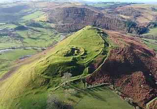
Cefnllys Castle was a medieval spur castle in Radnorshire, Wales. Two successive masonry castles were built on a ridge above the River Ithon known as Castle Bank in the thirteenth century, replacing a wooden motte-and-bailey castle constructed by the Normans nearby. Controlling several communication routes into the highlands of Mid Wales, the castles were strategically important within the Welsh Marches during the High Middle Ages. As the seat of the fiercely contested lordship and cantref of Maelienydd, Cefnllys became a source of friction between Llywelyn ap Gruffudd and Roger Mortimer in the prelude to Edward I's conquest of Wales. Cefnllys was also the site of a borough and medieval town.

Sycharth is a motte and bailey castle and town in Llansilin, Powys, Wales. Until 1996 Sycharth was in the historic county of Denbighshire, but was then transferred to the Shire area of Montgomeryshire within Powys. Sycharth Castle was the birthplace of Owain Glyndŵr.

Bramber Castle is a Norman motte-and-bailey castle formerly the caput of the large feudal barony of Bramber long held by the Braose family. It is situated in the village of Bramber, West Sussex, near the town of Steyning, overlooking the River Adur.

Loughor Castle is a ruined, medieval fortification located in the town of Loughor, Wales. The castle was built around 1106 by the Anglo-Norman lord Henry de Beaumont, during the Norman invasion of Wales. The site overlooked the River Loughor and controlled a strategic road and ford running across the Gower Peninsula. The castle was designed as an oval ringwork, probably topped by wicker fence defences, and reused the remains of the former Roman fort of Leucarum.

Hen Domen Welsh, meaning "old mound", is the site of a medieval timber motte-and-bailey castle in Powys, Wales. It is the site of the original Montgomery Castle, and was built by Roger de Montgomery in 1070. From 1105 the castle was the home of the de Boulers (Bowdler) family, and it is from Baldwin de Boulers that Montgomery gets its Welsh name, Trefaldwyn "The Town of Baldwin". When the castle was rebuilt in stone (1223–1234), it was decided to rebuild it on a rocky promontory a mile to the south-east – the location of the current town of Montgomery, Powys. The Hen Domen site has been extensively excavated.
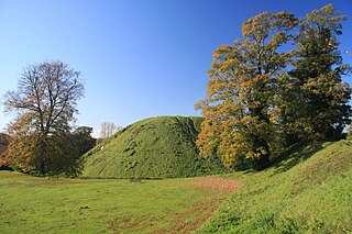
Thetford Castle is a medieval motte and bailey castle in the market town of Thetford in the Breckland area of Norfolk, England. The first castle in Thetford, a probable 11th century Norman ringwork called Red Castle, was replaced in the 12th century by a much larger motte and bailey castle on the other side of the town. This new castle was largely destroyed in 1173 by Henry II, although the huge motte, the second largest man-made mound in England, remained intact. The motte, recognised as a scheduled monument, now forms part of a local park, and the remains are known variously as Castle Hill, Castle Mound and Military Parade.

Pennard Castle is a ruined castle, near the modern village of Pennard on the Gower Peninsula, in south Wales. The castle was built in the early 12th century as a timber ringwork following the Norman invasion of Wales. The walls were rebuilt in stone by the Braose family at the turn of the 13th and 14th centuries, including a stone gatehouse. Soon afterwards, however, encroaching sand dunes caused the site to be abandoned and it fell into ruin. Restoration work was carried out during the course of the 20th century and the remains of the castle are now protected under UK law as a Grade II* listed building.

Ystrad Peithyll is the remains of a small 12th-century motte-and-bailey castle on the River Peithyll, near Penrhyn-coch in northern Ceredigion, Wales. The castle was attacked and destroyed by followers of Gruffydd ap Rhys in the early 12th century.
Pen y Clawdd Castle is a ditched mound with a double moat, roughly circular in shape, with a diameter of approximately 28m to 30m and about 2.4m high. The castle is in Llanvihangel Crucorney, about five miles to the north of Abergavenny, Monmouthshire, in south east Wales and lies between the Usk and Monnow rivers. The mound was designated a scheduled monument in 1950 and described as a defensive medieval motte.
Bleddfa Castle was a motte and bailey structure near Llangunllo in modern-day Powys, Wales. It is believed to have been built before 1195 and abandoned by 1304. What remains today is described as a "mutilated oval mound" of 46 by 36 metres, containing some traces of masonry. It is surrounded by a rectangular bailey measuring 100 by 60 metres, with a hedge on its northern border.
Buddugre Castle was a motte and bailey defensive fortification overlooking the River Ithon, located in the community of Llanddewi Ystradenny, in Radnorshire, Wales. It is believed to have been built as a defensive measure in the medieval period, during the 12th century, as a timber castle.
Castle Nimble was a motte and bailey defensive fortification near Old Radnor, in Radnorshire, Wales. Castle Nimble appears to have had an oval-shaped ditched motte, with a semi-rectangular bailey, and some other enclosures, including possibly a pond.

The Peel of Lumphanan, also known as the Peel Ring or Peel Bog of Lumphanan, is a defensive structure dating back to the 13th century. It is located near Lumphanan in Aberdeenshire, north-east Scotland.
Banc y Betws or Betws Castle, is a motte and scheduled ancient monument in Wales. It is located in Llangyndeyrn, in the Gwendraith Valley in Carmarthenshire, Wales; map grid SN458154. All that is visible of the structure nowadays is a mound capped with trees and the remains of the ditch that surrounded it.

Rhayader Castle is the remains of a motte-and-bailey castle in the town of Rhayader, Powys, Wales. The available documentary sources are not clear enough to distinguish between this site and the castle mound across the river and one or the other was probably built by Rhys ap Gruffydd, Prince of Deheubarth, in 1177. At that time the river formed the border between Gwrtheyrnion and the independent state of Buellt; the town of Rhayader is on the Gwrtheyrnion side of the river.

Edburton Castle Ring is an archaeological site in West Sussex, England, on the peak of Edburton Hill on the South Downs, near the villages of Edburton and Fulking. It is a Scheduled Monument.

