
St. Louis County is located in the eastern-central portion of Missouri. It is bounded by the City of St. Louis and the Mississippi River to the east, the Missouri River to the north, and the Meramec River to the south. At the 2020 census, the total population was 1,004,125, making it the most populous county in Missouri. Its county seat is Clayton. The county is included in the St. Louis, MO–IL metropolitan statistical area.
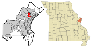
Berkeley is an inner-ring suburb of St. Louis, located in St. Louis County, Missouri, United States. The population was 8,228 at the 2020 census. Portions of St. Louis Lambert International Airport are within the city limits.

Kinloch is a city in St. Louis County, Missouri, United States. The population was 298 as of the 2010 census.
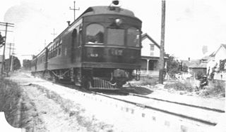
The Oregon Electric Railway (OE) was an interurban railroad line in the U.S. state of Oregon that linked Portland to Eugene. Service from Portland to Salem began in January 1908. The Spokane, Portland and Seattle Railway purchased the system in 1910, and extended service to Eugene in 1912. Regular passenger service in the Willamette Valley ended in May 1933. Freight operations continued and the railway survived into the 1990s, ultimately as a Burlington Northern feeder. Operation as an electric railroad ended July 10, 1945.

MetroLink is the Greater St. Louis Metropolitan mass transit system serving Missouri and the Metro East area of Illinois. The system consists of two rail lines connecting St. Louis Lambert International Airport and Shrewsbury, Missouri, with Scott Air Force Base near Shiloh, Illinois, Washington University, Forest Park, and Downtown St. Louis. The system operates as underground subway in Downtown St. Louis and as underground subway through portions near Forest Park and Clayton to the west. The system features 38 stations and is the only light rail system in the United States to cross state lines. In 2022, the system had a ridership of 6,702,600, or about 20,500 per weekday as of the fourth quarter of 2022. As of the third quarter of 2020, it is second only to Minneapolis Metro Transit in the Midwestern United States in terms of light rail ridership, and is the 11th-largest light rail system in the country.
The Key System was a privately owned company that provided mass transit in the cities of Oakland, Berkeley, Alameda, Emeryville, Piedmont, San Leandro, Richmond, Albany, and El Cerrito in the eastern San Francisco Bay Area from 1903 until 1960, when it was sold to a newly formed public agency, AC Transit. The Key System consisted of local streetcar and bus lines in the East Bay, and commuter rail and bus lines connecting the East Bay to San Francisco by a ferry pier on San Francisco Bay, later via the lower deck of the Bay Bridge. At its height during the 1940s, the Key System had over 66 miles (106 km) of track. The local streetcars were discontinued in 1948 and the commuter trains to San Francisco were discontinued in 1958. The Key System's territory is today served by BART and AC Transit bus service.
The St. Louis Car Company was a major United States manufacturer of railroad passenger cars, streetcars, interurbans, trolleybuses and locomotives that existed from 1887 to 1974, based in St. Louis, Missouri.
Solano Avenue in Berkeley and Albany, California is a two-mile (3.2 km) long east-west street. Solano Avenue is one of the larger shopping districts in the Berkeley area. Businesses along Solano Avenue cover a wide range, including grocery stores, coffee shops, drugstores, bookstores, antique dealers, apparel outlets, ethnic restaurants and a movie theater.

The East Bay Electric Lines were a unit of the Southern Pacific Railroad that operated electric interurban-type trains in the East Bay region of the San Francisco Bay Area. Beginning in 1862, the SP and its predecessors operated local steam-drawn ferry-train passenger service in the East Bay on an expanding system of lines, but in 1902 the Key System started a competing system of electric lines and ferries. The SP then drew up plans to expand and electrify its system of lines and this new service began in 1911. The trains served the cities of Berkeley, Albany, Emeryville, Oakland, Alameda, and San Leandro transporting commuters to and from the large Oakland Pier and SP Alameda Pier. A fleet of ferry boats ran between these piers and the docks of the Ferry Building on the San Francisco Embarcadero.
The Minnesota Streetcar Museum (MSM) is a transport museum that operates two heritage streetcar lines in Minneapolis, Minnesota and the western suburb of Excelsior.
The Arkansas Valley Interurban Railway (AVI) was an interurban railway that operated in Kansas USA from 1910 to 1938 for passengers and to 1942 for freight, running between Wichita, Newton, and Hutchinson. It operated a small fleet of electrically powered passenger and freight equipment. Service was suspended during World War II and never resumed, except on a small portion owned the Hutchinson and Northern Railroad which is still in operation. (2020)

Erastus Wells was a 19th-century politician and businessman from Missouri. Wells was born in Jefferson County, New York, and was the only son of Otis Wells, a descendant of Hugh Welles, an early colonist of Wethersfield, Connecticut. Otis Wells was a farmer and died when Erastus was only fourteen. Erastus was the grandson of Ethelinda Otis and a relation of John Otis, who helped found the town of Hingham, Massachusetts in 1635. Other notable relatives include James Otis, a successful lawyer, Harrison Gray Otis, a statesman and orator, Samuel A. Otis, one of the framers of the constitution of Massachusetts, and George Otis, a clergyman and author.

College Hill is a neighborhood of the City of St. Louis, Missouri. The name College Hill was given to this area because it was the location of the Saint Louis University College Farm. This area, bounded generally by Warne Ave., O'Fallon Park, I-70, Grand Boulevard, and W. Florissant Ave., was acquired by the University for garden and recreation purposes in 1836. It was subdivided in the early 1870s.

The Ferguson-Florissant School District (FFSD) is a public school district located in Greater St. Louis and in Missouri. Its headquarters are in Hazelwood. The district covers all or part of 11 municipalities, serving more than 11,000 students from preschool through 12th grade.

The Upland–San Bernardino Line was an interurban line operated by the Pacific Electric Railway between Downtown Los Angeles and San Bernardino, California. This line also had shorter service that terminated before the end of the line at Baldwin Park, Covina, and San Dimas. Though service along this line in its entirety was discontinued in November 1941, it stands as the fourth-longest rapid transit line in American history, after the Sacramento Northern Chico and Colusa services, and the Pacific Electric's own Riverside–Rialto Line.

Streetcars in St. Louis, Missouri operated as part of the transportation network of St. Louis from the middle of the 19th century through the early 1960s. During the first forty years of the streetcar in the city, a variety of private companies operated several dozen lines. In 1898, the City of St. Louis passed a Central Traction Bill that required franchises for streetcar companies. United Railways quickly consolidated most St. Louis streetcar companies. Only St. Louis Suburban remained independent. It was acquired by United Railways in 1906. United Railways sank into receivership which was resolved only in 1924. It was reorganized as St. Louis Public Service Company in 1927, and became Bi-State in 1963. St. Louis Public Service Company served both the city of St. Louis and neighboring St. Louis County, Missouri. Other private companies, such as those serving the Metro East region or St. Charles, Missouri, continued separate operations. Starting in the 1930s and continuing through the 1960s, St. Louis Public Service ended all streetcar service, while other regional operators also ended their services.

The Wabash Railroad was a Class I railroad that operated in the mid-central United States. It served a large area, including track in the states of Ohio, Indiana, Illinois, Iowa, Michigan, and Missouri and the province of Ontario. Its primary connections included Chicago, Illinois; Kansas City, Missouri; Detroit, Michigan; Buffalo, New York; St. Louis, Missouri; and Toledo, Ohio.

The Venice Short Line was a Pacific Electric interurban railway line in Los Angeles which traveled from downtown Los Angeles to Venice, Ocean Park, and Santa Monica via Venice Boulevard.
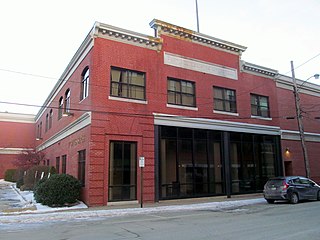
The Portland–Lewiston Interurban (PLI) was an electric railroad subsidiary of the Androscoggin Electric Company operating from 1914 to 1933 between Monument Square in Portland and Union Square in Lewiston, Maine. Hourly service was offered over the 40-mile (64 km) route between the two cities. Express trains stopping only at West Falmouth, Gray, New Gloucester, Upper Gloucester and Danville made the trip in 80 minutes, while trains making other local stops upon request required 20 minutes more. The line was considered the finest interurban railroad in the state of Maine.

The Venice–Inglewood Line is a former Pacific Electric interurban railway line in Los Angeles County, California. Service was very sparse, providing a suburban route between Venice and Inglewood.


