Uplands Park, Missouri

Last updated

Uplands Park, Missouri
Welcome to the Village of Uplands Park (28198530363).jpg
Welcome sign for Uplands Park, Missouri, July 2016
St. Louis County Missouri Incorporated and Unincorporated areas Uplands Park Highlighted.svg
Location of Uplands Park, Missouri
Coordinates: 38°41′34″N90°16′58″W / 38.69278°N 90.28278°W / 38.69278; -90.28278
Country United States
State Missouri
County St. Louis
Area
[1]
  Total0.07 sq mi (0.17 km2)
  Land0.07 sq mi (0.17 km2)
  Water0.00 sq mi (0.00 km2)
Elevation
[2]
604 ft (184 m)
Population
 (2020)
  Total312
  Density4,727.27/sq mi (1,826.67/km2)
Time zone UTC-6 (Central (CST))
  Summer (DST) UTC-5 (CDT)
ZIP code
63121 [3]
Area code 314
FIPS code 29-75238 [4]
GNIS feature ID2400031 [2]

Uplands Park is a village in St. Louis County, Missouri, United States. The population was 445 at the 2010 census. [5] The village is one of many small majority black communities located in the Natural Bridge corridor of mid-St. Louis County, characterized by small homes on small lots.

Contents

Geography

According to the United States Census Bureau, the village has a total area of 0.07 square miles (0.18 km2), all land. [6]

Demographics

Historical population
CensusPop.Note
1950 563
1960 549−2.5%
1970 69526.6%
1980 576−17.1%
1990 499−13.4%
2000 460−7.8%
2010 445−3.3%
2020 312−29.9%
U.S. Decennial Census [7]

2010 census

As of the census [8] of 2010, there were 445 people, 168 households, and 127 families living in the village. The population density was 6,357.1 inhabitants per square mile (2,454.5/km2). There were 187 housing units at an average density of 2,671.4 per square mile (1,031.4/km2). The racial makeup of the village was 2.0% White, 96.4% African American, 1.1% Native American, and 0.4% from other races. Hispanic or Latino of any race were 1.1% of the population.

There were 168 households, of which 32.1% had children under the age of 18 living with them, 36.9% were married couples living together, 31.0% had a female householder with no husband present, 7.7% had a male householder with no wife present, and 24.4% were non-families. 20.2% of all households were made up of individuals, and 8.9% had someone living alone who was 65 years of age or older. The average household size was 2.65 and the average family size was 3.04.

The median age in the village was 45.2 years. 21.8% of residents were under the age of 18; 7.8% were between the ages of 18 and 24; 20.1% were from 25 to 44; 30.4% were from 45 to 64; and 20% were 65 years of age or older. The gender makeup of the village was 44.7% male and 55.3% female.

2000 census

As of the census [4] of 2000, there were 460 people, 166 households, and 129 families living in the village. The population density was 6,904.3 inhabitants per square mile (2,665.8/km2). There were 181 housing units at an average density of 2,716.7 per square mile (1,048.9/km2). The racial makeup of the village was 1.30% White, 97.39% African American, 0.22% Asian, and 1.09% from two or more races. Hispanic or Latino of any race were 0.87% of the population.

There were 166 households, out of which 20.5% had children under the age of 18 living with them, 45.2% were married couples living together, 24.7% had a female householder with no husband present, and 21.7% were non-families. 18.7% of all households were made up of individuals, and 9.6% had someone living alone who was 65 years of age or older. The average household size was 2.77 and the average family size was 3.05.

In the village, the population was spread out, with 24.3% under the age of 18, 5.9% from 18 to 24, 22.0% from 25 to 44, 30.9% from 45 to 64, and 17.0% who were 65 years of age or older. The median age was 43 years. For every 100 females, there were 98.3 males. For every 100 females age 18 and over, there were 88.1 males.

The median income for a household in the village was $49,286, and the median income for a family was $54,250. Males had a median income of $28,333 versus $25,114 for females. The per capita income for the village was $17,041. About 3.9% of families and 4.8% of the population were below the poverty line, including 3.6% of those under age 18 and 5.8% of those age 65 or over.

Related Research Articles

<span class="mw-page-title-main">Upland, Indiana</span> Town in Indiana, United States

Upland is a town in Jefferson Township, Grant County, Indiana, United States. The population was 3,821 at the 2020 census. It is the home of Taylor University, a Christian college.

<span class="mw-page-title-main">Richland, Michigan</span> Village in Michigan, United States

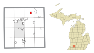
Richland is a village in Kalamazoo County in the U.S. state of Michigan. The population was 751 at the 2010 census, up from 593 at the 2000 census.

<span class="mw-page-title-main">Cedar Hill Lakes, Missouri</span> Village in Missouri, United States

Cedar Hill Lakes is a village in Jefferson County, Missouri, United States. The population was 203 at the 2020 census.

<span class="mw-page-title-main">Evergreen, Missouri</span> Village in Missouri, United States

Evergreen is a village in Laclede County, Missouri, United States. The population was 28 at the 2010 census. It was named Twin Bridges at the 2000 census.

<span class="mw-page-title-main">Sycamore Hills, Missouri</span> Village in Missouri, United States

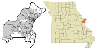
Sycamore Hills is a village in St. Louis County, Missouri, United States. The population is 560 at the 2020 census.

<span class="mw-page-title-main">Penermon, Missouri</span> Village in Missouri, United States

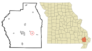
Penermon is a village in Stoddard County, Missouri, United States. The population was 64 at the 2010 census.

<span class="mw-page-title-main">Upland, Nebraska</span> Village in Nebraska, United States

Upland is a village in Franklin County, Nebraska, United States. The population was 143 at the 2010 census.

<span class="mw-page-title-main">Champ, Missouri</span> Village in Missouri, United States

Champ is a village in St. Louis County, Missouri, United States. The population was 10 at the 2020 census.

<span class="mw-page-title-main">Elmwood Place, Ohio</span> Village in Hamilton County, Ohio, United States

Elmwood Place is a village in Hamilton County, Ohio, United States. The population was 2,087 at the 2020 census. Except for a small portion which touches neighboring St. Bernard, Elmwood Place is nearly surrounded by the city of Cincinnati.

<span class="mw-page-title-main">Hanover, Ohio</span> Village in Ohio, United States

Hanover is a village in Licking County, Ohio, United States. The population was 1,270 at the 2020 census. The village lies along Ohio State Route 16.

<span class="mw-page-title-main">Miltonsburg, Ohio</span> Village in Ohio, United States

Miltonsburg is a village in Monroe County, Ohio, United States. The population was 42 at the 2020 census. Miltonsburg was named after Milton Pierson, son of Ohio pioneer David Pierson. David Pierson named Clarington, Ohio after his daughter Clarinda.

<span class="mw-page-title-main">Roswell, Ohio</span> Village in Ohio, United States

Roswell is a village in Tuscarawas County, Ohio, United States. The population was 219 at the 2020 census.

<span class="mw-page-title-main">Bethlehem, West Virginia</span> Village in West Virginia, United States

Bethlehem is a village in Ohio County, West Virginia, United States. It is part of the Wheeling, West Virginia Metropolitan Statistical Area. The population was 2,499 at the 2010 census.

<span class="mw-page-title-main">Clearview, West Virginia</span> Village in West Virginia, United States

Clearview is a village in Ohio County, West Virginia, United States. It is part of the Wheeling, West Virginia Metropolitan Statistical Area. The population was 565 at the 2010 census.

<span class="mw-page-title-main">Steuben, Wisconsin</span> Village in Wisconsin, United States

Steuben is a village in Crawford County, Wisconsin, United States. The population was 131 at the 2010 census.

<span class="mw-page-title-main">Kekoskee, Wisconsin</span> Village in Wisconsin, United States

Kekoskee is a village in Dodge County, Wisconsin, United States. The population was 161 at the 2010 census.

<span class="mw-page-title-main">Wilson, Ohio</span> Village in Ohio, United States

Wilson is a village in Belmont and Monroe counties in the U.S. state of Ohio. The population was 129 at the 2020 census. It is part of the Wheeling metropolitan area.

<span class="mw-page-title-main">Dorchester, Wisconsin</span> Village in Wisconsin, United States

Dorchester is a village in Clark and Marathon counties in the U.S. state of Wisconsin, along the 45th parallel. It is part of the Wausau, Wisconsin Metropolitan Statistical Area. The population was 876 at the 2010 census. Of this, 871 were in Clark County, and only 5 were in Marathon County.

<span class="mw-page-title-main">Black Earth, Wisconsin</span> Village in Wisconsin, United States

Black Earth is a village in Dane County, Wisconsin, United States. The population was 1,338 at the 2010 census. The village is located within the Town of Black Earth. It is part of the Madison Metropolitan Statistical Area.

<span class="mw-page-title-main">Wilton, Wisconsin</span> Village in Wisconsin, United States

Wilton is a village in Monroe County, Wisconsin, United States. The population was 504 at the 2010 census. The village is located partially within the Town of Wilton and partially within the Town of Wellington.

References

  1. "ArcGIS REST Services Directory". United States Census Bureau. Retrieved August 28, 2022.
  2. 1 2 U.S. Geological Survey Geographic Names Information System: Uplands Park, Missouri
  3. "Uplands Park MO ZIP Code". zipdatamaps.com. 2023. Retrieved June 16, 2023.
  4. 1 2 "U.S. Census website". United States Census Bureau . Retrieved January 31, 2008.
  5. "Race, Hispanic or Latino, Age, and Housing Occupancy: 2010 Census Redistricting Data (Public Law 94-171) Summary File (QT-PL), Uplands Park village, Missouri". United States Census Bureau . Retrieved October 26, 2011.
  6. "US Gazetteer files 2010". United States Census Bureau. Archived from the original on January 25, 2012. Retrieved July 8, 2012.
  7. "Census of Population and Housing". Census.gov. Retrieved June 4, 2015.
  8. "U.S. Census website". United States Census Bureau . Retrieved July 8, 2012.