Vinita Park, Missouri

Last updated
Vinita Park, Missouri
St. Louis County Missouri Incorporated and Unincorporated areas Vinita Park Highlighted.svg
Location of Vinita Park, Missouri
Coordinates: 38°41′20″N90°20′21″W / 38.68889°N 90.33917°W / 38.68889; -90.33917 Coordinates: 38°41′20″N90°20′21″W / 38.68889°N 90.33917°W / 38.68889; -90.33917
Country United States
State Missouri
County St. Louis
Area
[1]
  Total0.78 sq mi (2.02 km2)
  Land0.78 sq mi (2.02 km2)
  Water0.00 sq mi (0.00 km2)
Elevation
[2]
594 ft (181 m)
Population
 (2020)
  Total1,970
  Density2,525.64/sq mi (975.60/km2)
Time zone UTC-6 (Central (CST))
  Summer (DST) UTC-5 (CDT)
FIPS code 29-76246 [3]
GNIS feature ID2397148 [2]
Website Website from the St. Louis County website

Vinita Park is a city in St. Louis County, Missouri, United States, located just east of I-170 and south of St. Charles Rock Road. The population was 1,970 at the 2020 census. [4]

Contents

Geography

According to the United States Census Bureau, the city has a total area of 0.72 square miles (1.86 km2), all land. [5]

Demographics

Historical population
CensusPop.Note
1950 1,801
1960 2,20422.4%
1970 3,68467.2%
1980 2,283−38.0%
1990 2,001−12.4%
2000 1,924−3.8%
2010 1,880−2.3%
2020 1,9704.8%
U.S. Decennial Census [6]

2020 census

As of the 2020 census there were 1,970 people and 709 households living in the city. The racial makeup of the city was 25.2% White (23.8% non-Hispanic White), 62.4% African American, 0.8% Native American, 1.0% Asian, 6.0% from other races, and 4.6% from two or more races. Hispanic or Latino of any race were 7.9% of the population. [4]

2010 census

As of the census [7] of 2010, there were 1,880 people, 761 households, and 496 families living in the city. The population density was 2,611.1 inhabitants per square mile (1,008.2/km2). There were 849 housing units at an average density of 1,179.2 per square mile (455.3/km2). The racial makeup of the city was 30.1% White, 64.9% African American, 0.5% Native American, 0.2% Asian, 2.0% from other races, and 2.2% from two or more races. Hispanic or Latino of any race were 4.7% of the population.

There were 761 households, of which 33.6% had children under the age of 18 living with them, 34.0% were married couples living together, 24.6% had a female householder with no husband present, 6.6% had a male householder with no wife present, and 34.8% were non-families. 29.7% of all households were made up of individuals, and 8.1% had someone living alone who was 65 years of age or older. The average household size was 2.46 and the average family size was 3.06.

The median age in the city was 33.6 years. 24.6% of residents were under the age of 18; 9.4% were between the ages of 18 and 24; 31.2% were from 25 to 44; 24.9% were from 45 to 64; and 9.8% were 65 years of age or older. The gender makeup of the city was 48.6% male and 51.4% female.

2000 census

As of the census [3] of 2000, there were 1,924 people, 752 households, and 515 families living in the city. The population density was 2,628.7 inhabitants per square mile (1,014.9/km2). There were 841 housing units at an average density of 1,149.0 per square mile (443.6/km2). The racial makeup of the city was 61.75% African American, 33.00% White, 1.09% Asian, 0.36% Native American, 1.04% from other races, and 2.75% from two or more races. Hispanic or Latino of any race were 1.51% of the population.

There were 752 households, out of which 34.3% had children under the age of 18 living with them, 36.8% were married couples living together, 25.1% had a female householder with no husband present, and 31.4% were non-families. 26.3% of all households were made up of individuals, and 7.0% had someone living alone who was 65 years of age or older. The average household size was 2.56 and the average family size was 3.10.

In the city the population was spread out, with 29.6% under the age of 18, 9.3% from 18 to 24, 33.2% from 25 to 44, 18.0% from 45 to 64, and 9.9% who were 65 years of age or older. The median age was 31 years. For every 100 females, there were 87.3 males. For every 100 females age 18 and over, there were 80.4 males.

The median income for a household in the city was $29,482, and the median income for a family was $33,523. Males had a median income of $27,228 versus $23,951 for females. The per capita income for the city was $15,274. About 15.1% of families and 16.5% of the population were below the poverty line, including 25.0% of those under age 18 and 9.8% of those age 65 or over.

History

The City of Vinita Park—along with the Village of Vinita Terrace—gets its name from "Vinita Station", an electric rail car station that was located at the intersection of Midland and Page. The Vinita Park subdivision was laid out in 1905 by A.C. Stewart and was later marketed by Everett Davis, of the Davis Realty Development Company. A map titled "Vinita Park -- "The Next Reach", by the Davis Realty Development Company, [8] is dated 1909 and can be found in the Library of Congress. On November 3, 1941, Vinita Park was incorporated [9] as a village, including the northern subdivisions of Spring Avenue Heights and part of Midland Heights, the Atherton (south of Page Boulevard), and the Vinita Industrial Park. On March 13, 1950, Vinita Park changed its status to a City of the 4th Class. Voters of both Vinita Park and neighboring Vinita Terrace voted on November 8, 2016, to consolidate into one municipality, to be called the City of Vinita Park. [10] [11] The merger took effect on May 10, 2017. [12]

Education

St. Louis County Library operates the Indian Trails Branch in Vinita Park. [13] [14] Vinita Park has three different school districts: Normandy, Ritenour, and University City.

Government

Vinita Park has a mayor and a board of aldermen. The mayor is elected to a four-year term and aldermen are elected to two-year terms. There are three ward divisions which each elect two alderman as required by Missouri law. [15] Therefore, there are six aldermen in Vinita Park. If there is ever a tie vote in the board of aldermen, the mayor casts a tie-breaking vote but otherwise does not vote.

Police department

On June 1, 2015, Vinita Park initiated the North County Police Cooperative. They have partnered with nearby cities, Vinita Terrace and Wellston in providing police services to their communities. The cooperative currently has 30 police officers providing police protection in the area.

Related Research Articles

<span class="mw-page-title-main">Odessa, Missouri</span> City in Missouri, United States

Odessa is the largest city in Lafayette County, Missouri, and part of the Kansas City metropolitan area within the Midwestern United States. The population was 5,593 at the 2020 census. Located along Interstate 70 Odessa's historic downtown is home to a range of boutique shops and restaurants. The city is host to the annual Puddle Jumper Days town fair, the Odessa Rodeo, a Christmas lighting ceremony and various other community events held throughout the year.

<span class="mw-page-title-main">Versailles, Missouri</span> City in Missouri, United States

Versailles is a city in Morgan County, Missouri, United States. The population was 2,482 at the 2010 census. It is the county seat of Morgan County. Locally, the town's name is pronounced “Ver-sails”, rather than “Ver-seye,” as in the French pronunciation of the royal palace for which the town is named.

<span class="mw-page-title-main">Parkville, Missouri</span> City in Missouri, United States

Parkville is a city in Platte County, Missouri, United States and is a part of the Kansas City Metropolitan Area. The population was 7,177 at the 2020 census. Parkville is known for its antique shops, art galleries, and historic downtown. The city is home to Park University, English Landing Park, Platte Landing Park, and the National Golf Club of Kansas City. Large neighborhoods in Parkville include: Riss Lake, The National, Thousand Oaks, Creekside, Parkville Heights, River Hills, Riverchase, The Bluffs, Downtown, and Pinecrest.

<span class="mw-page-title-main">Bellefontaine Neighbors, Missouri</span> City in Missouri, United States

Bellefontaine Neighbors is an inner-ring suburb city in St. Louis County, Missouri, United States. The population was 10,860 at the 2010 census.

<span class="mw-page-title-main">Crestwood, Missouri</span> City in Missouri, United States

Crestwood is a city in south St. Louis County, Missouri, United States, part of the Metropolitan Statistical Area known as Greater St. Louis. The population was 11,912 at the 2010 census.

<span class="mw-page-title-main">Crystal Lake Park, Missouri</span> City in Missouri, United States

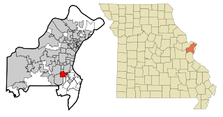
Crystal Lake Park is a Missouri Class 4 city in St. Louis County, Missouri, United States. The population was 508 at the 2020 census.

<span class="mw-page-title-main">Edmundson, Missouri</span> City in Missouri, United States

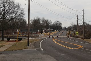
Edmundson is a city in St. Louis County, Missouri, United States. The population was estimated to be 860 at the time of the 2020 census.

<span class="mw-page-title-main">Green Park, Missouri</span> City in Missouri, United States

Green Park is a city in St. Louis County, Missouri, United States. The population was 2,622 at the 2010 census.

<span class="mw-page-title-main">Pasadena Park, Missouri</span> Village in Missouri, United States

Pasadena Park is a village in St. Louis County, Missouri, United States. The population was 470 at the 2010 census. It is part of the Normandy School District, and is distinct from the city of Pasadena Hills.

<span class="mw-page-title-main">Vinita Terrace, Missouri</span> Former Village in Missouri, United States

Vinita Terrace was a village in St. Louis County, Missouri, United States. The population was 277 at the 2010 census.

<span class="mw-page-title-main">Wildwood, Missouri</span> City in Missouri, United States

Wildwood is a city in St. Louis County, Missouri, United States. It is located in the far western portion of the county. As of the 2020 census, the population was 35,417. Wildwood is the home of the Al Foster Trail, and numerous other trails, parks, and reserves such as Rockwoods Reservation and Babler State Park.

<span class="mw-page-title-main">Winchester, Missouri</span> City in Missouri, United States

Winchester is a city in St. Louis County, Missouri, United States. The population was 1,447 at the 2020 census.

<span class="mw-page-title-main">Woodson Terrace, Missouri</span> City in Missouri, United States

Woodson Terrace is a city in St. Louis County, Missouri, United States. The population was 4,063 at the 2010 census.

<span class="mw-page-title-main">Marshfield, Missouri</span> City in Missouri, United States

Marshfield is a city in Missouri and the county seat of Webster County, Missouri. As of the 2010 census, the city population was 6,633. As of the 2020 census, Marshfield had a population of 7,458. It is part of the Springfield, Missouri, metropolitan area.

<span class="mw-page-title-main">Clayton, Missouri</span> City in Missouri, United States

Clayton is a city in and the seat of St. Louis County, Missouri. It borders the independent city of St. Louis. The population was 17,355 at the 2020 census. Organized in 1877, the city was named after Ralph Clayton, who donated the land for the St. Louis County courthouse.

<span class="mw-page-title-main">St. Ann, Missouri</span> City in Missouri, United States

St. Ann or Saint Ann is a city in northwest St. Louis County, Missouri, United States. The population was 13,019 at the 2020 census.

<span class="mw-page-title-main">Forsyth, Missouri</span> City in Missouri, United States

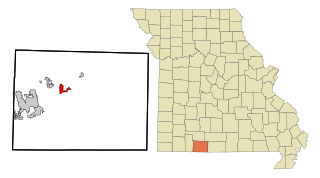
Forsyth is a city in Taney County, Missouri, United States. The population was 2,730 at the 2020 census. It is the county seat of Taney County. The town is part of the Branson, Missouri Micropolitan Statistical Area. Forsyth is located on Lake Taneycomo on U.S. Route 160.

<span class="mw-page-title-main">Lawson, Missouri</span> City in Missouri, United States

Lawson is a city in Clay, Clinton, and Ray counties in the U.S. state of Missouri and part of the Kansas City metropolitan area. The population was 2,541 at the 2020 census.

<span class="mw-page-title-main">Sullivan, Missouri</span> City in Missouri, United States

Sullivan is a city that straddles the border of Franklin and Crawford counties in the U.S. state of Missouri. The population was 6,906 at the 2020 census.

<span class="mw-page-title-main">Foristell, Missouri</span> City in Missouri, United States

Foristell is a city in St. Charles and Warren counties in the U.S. state of Missouri. The population was 505 at the 2010 census.

References

  1. "ArcGIS REST Services Directory". United States Census Bureau. Retrieved August 28, 2022.
  2. 1 2 U.S. Geological Survey Geographic Names Information System: Vinita Park, Missouri
  3. 1 2 "U.S. Census website". United States Census Bureau . Retrieved 2008-01-31.
  4. 1 2 "United States Census Bureau" . Retrieved February 6, 2022.
  5. "US Gazetteer files 2010". United States Census Bureau. Archived from the original on 2012-01-25. Retrieved 2012-07-08.
  6. "Census of Population and Housing". Census.gov. Retrieved June 4, 2015.
  7. "U.S. Census website". United States Census Bureau . Retrieved 2012-07-08.
  8. "" Book Reference
  9. "" 1950 Census
  10. "" City of Vinita Park General Election Results
  11. "" City of Vinita Terrace General Election Results
  12. "Tiny North County community Vinita Terrace merging into Vinita Park".
  13. "Indian Trails Branch Archived 2009-08-13 at the Wayback Machine ." St. Louis County Library. Retrieved on August 18, 2009.
  14. "Vinita Park city, Missouri [ permanent dead link ]." U.S. Census Bureau . Retrieved on August 18, 2009.
  15. MO statutes