Pasadena Park, Missouri

Last updated

Pasadena Park, Missouri
Pasadena Park.jpg
St. Louis County Missouri Incorporated and Unincorporated areas Pasadena Park Highlighted.svg
Location of Pasadena Park, Missouri
Coordinates: 38°42′40″N90°17′51″W / 38.71111°N 90.29750°W / 38.71111; -90.29750
Country United States
State Missouri
County St. Louis
Area
[1]
  Total0.10 sq mi (0.25 km2)
  Land0.10 sq mi (0.25 km2)
  Water0.00 sq mi (0.00 km2)
Elevation
[2]
620 ft (190 m)
Population
 (2020)
  Total435
  Density4,438.78/sq mi (1,712.03/km2)
Time zone UTC-6 (Central (CST))
  Summer (DST) UTC-5 (CDT)
FIPS code 29-56414 [3]
GNIS feature ID2399628 [2]
i

Pasadena Park is a village in St. Louis County, Missouri, United States. The population was 470 at the 2010 census. [4] It is part of the Normandy School District, and is distinct from the city of Pasadena Hills.

Contents

Geography

According to the United States Census Bureau, the village has a total area of 0.10 square miles (0.26 km2), all land. [5]

Demographics

Historical population
CensusPop.Note
1940 659
1950 6823.5%
1960 680−0.3%
1970 76011.8%
1980 531−30.1%
1990 5320.2%
2000 489−8.1%
2010 470−3.9%
2020 435−7.4%
U.S. Decennial Census [6]

2010 census

As of the census [7] of 2010, there were 470 people, 221 households, and 127 families living in the village. The population density was 4,700.0 inhabitants per square mile (1,814.7/km2). There were 232 housing units at an average density of 2,320.0 per square mile (895.8/km2). The racial makeup of the village was 35.1% White, 60.6% African American, 1.3% Asian, 1.1% from other races, and 1.9% from two or more races. Hispanic or Latino of any race were 0.9% of the population.

There were 221 households, of which 24.4% had children under the age of 18 living with them, 31.7% were married couples living together, 21.7% had a female householder with no husband present, 4.1% had a male householder with no wife present, and 42.5% were non-families. 35.7% of all households were made up of individuals, and 10.4% had someone living alone who was 65 years of age or older. The average household size was 2.13 and the average family size was 2.72.

The median age in the village was 45.5 years. 17.2% of residents were under the age of 18; 6.8% were between the ages of 18 and 24; 25.1% were from 25 to 44; 34.3% were from 45 to 64; and 16.6% were 65 years of age or older. The gender makeup of the village was 43.2% male and 56.8% female.

2000 census

As of the census [3] of 2000, there were 489 people, 226 households, and 127 families living in the village. The population density was 5,506.5 inhabitants per square mile (2,126.1/km2). There were 232 housing units at an average density of 2,612.5 per square mile (1,008.7/km2). The racial makeup of the village was 40.08% White, 53.37% African American, 0.41% Native American, 1.84% Asian, 2.25% from other races, and 2.04% from two or more races. Hispanic or Latino of any race were 2.45% of the population.

There were 226 households, out of which 27.0% had children under the age of 18 living with them, 36.3% were married couples living together, 16.4% had a female householder with no husband present, and 43.4% were non-families. 34.1% of all households were made up of individuals, and 8.4% had someone living alone who was 65 years of age or older. The average household size was 2.16 and the average family size was 2.82.

In the village, the population was spread out, with 21.5% under the age of 18, 6.1% from 18 to 24, 34.2% from 25 to 44, 27.2% from 45 to 64, and 11.0% who were 65 years of age or older. The median age was 40 years. For every 100 females, there were 83.1 males. For every 100 females age 18 and over, there were 82.0 males.

The median income for a household in the village was $44,712, and the median income for a family was $47,083. Males had a median income of $34,844 versus $34,250 for females. The per capita income for the village was $28,274. About 7.2% of families and 10.3% of the population were below the poverty line, including 15.8% of those under age 18 and 21.4% of those age 65 or over.

Related Research Articles

<span class="mw-page-title-main">East Pasadena, California</span> Place in California, United States

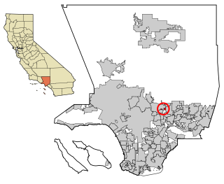
East Pasadena is an unincorporated community in Los Angeles County, California, United States. The population was 6,144 at the 2010 census, up from 6,045 at the 2000 census. For statistical purposes, the United States Census Bureau has defined East Pasadena as a census-designated place (CDP).

<span class="mw-page-title-main">Onsted, Michigan</span> Village in Michigan, United States

Onsted is a village within Lenawee County in the U.S. state of Michigan. The village had a population of 988 at the 2020 census. Located within the Irish Hills region, the village is part of Cambridge Township.

<span class="mw-page-title-main">Miramiguoa Park, Missouri</span> Village in Missouri, United States

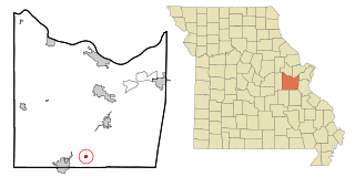
Miramiguoa Park is a village in Franklin County, Missouri, United States. The population was 120 at the 2010 census.

<span class="mw-page-title-main">Halfway, Missouri</span> Village in Missouri, United States

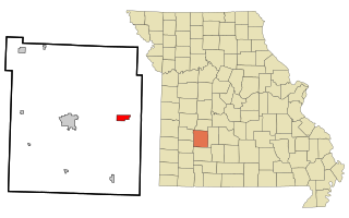
Halfway is a village in Polk County, Missouri, United States. According to the 2010 census, the population of Halfway is 173. It is part of the Springfield, Missouri Metropolitan Statistical Area.

<span class="mw-page-title-main">Norwood Court, Missouri</span> Village in Missouri, United States

Norwood Court is a village in St. Louis County, Missouri, United States. The population was 959 at the 2010 census.

<span class="mw-page-title-main">Pasadena Hills, Missouri</span> City in Missouri, United States

Pasadena Hills is a city in St. Louis County, Missouri, United States. The population was 930 at the 2010 census. The entire city is listed on the National Register of Historic Places.

<span class="mw-page-title-main">Manley, Nebraska</span> Village in Nebraska, United States

Manley is a village in Cass County, Nebraska, United States. The population was 167 at the 2020 census.

<span class="mw-page-title-main">Haywood City, Missouri</span> Village in Missouri, United States

Haywood City is a village in Scott County, Missouri, United States. The population was 206 at the 2010 census.

<span class="mw-page-title-main">Hanley Hills, Missouri</span> Village in Missouri, United States

Hanley Hills is a village in St. Louis County, Missouri, United States. The population was 2,101 at the 2010 census.

<span class="mw-page-title-main">Shawnee Hills, Delaware County, Ohio</span> Village in Ohio, United States

Shawnee Hills is a village in Delaware County, Ohio, United States. The population was 835 at the 2020 census. It is a part of the Columbus, Ohio Metropolitan Statistical Area.

<span class="mw-page-title-main">Brice, Ohio</span> Village in Ohio, United States

Brice is a village in Franklin County, Ohio, United States, on the southeast side of the Columbus metropolitan area. The population was 93 at the 2020 census.

<span class="mw-page-title-main">Addyston, Ohio</span> Village in Ohio, United States

Addyston is a village in Miami Township, Hamilton County, Ohio, United States, along the Ohio River. The population was 927 at the 2020 census.

<span class="mw-page-title-main">Sheffield, Ohio</span> Village in Ohio, United States

Sheffield is a village in Lorain County, Ohio, United States, along the Black River. The population was 4,135 at the 2020 census. It is part of the Cleveland metropolitan area.

<span class="mw-page-title-main">Haviland, Ohio</span> Village in Ohio, United States

Haviland is a village in Paulding County, Ohio, United States. The population was 215 at the 2010 census.

<span class="mw-page-title-main">Bellevue, Wisconsin</span> Village in Wisconsin, United States

Bellevue is a village in Brown County, Wisconsin. It was a town until incorporating as a village on February 14, 2003. The population was 14,570 at the time of the 2010 census. Bellevue is part of the Green Bay metropolitan area. Bellevue sits around 4.34 miles (6.99km) east from central Green Bay.

<span class="mw-page-title-main">Friesland, Wisconsin</span> Village in Wisconsin, United States

Friesland is a village in Columbia County, Wisconsin, United States. The population was 320 at the 2020 census. It is part of the Madison Metropolitan Statistical Area.

<span class="mw-page-title-main">Cecil, Wisconsin</span> Village in Wisconsin, United States

Cecil is a village in Shawano County, Wisconsin, United States. The population was 570 at the 2010 census.

<span class="mw-page-title-main">Hubbardston, Michigan</span> Village in Michigan, United States

Hubbardston is a village in the U.S. state of Michigan. It is mostly in North Plains Township in Ionia County, and partially in Lebanon Township in Clinton County. Its population was 395 at the 2010 census.

<span class="mw-page-title-main">Verona, Ohio</span> Village in Ohio, United States

Verona is a village in Montgomery and Preble counties in the U.S. state of Ohio. The population was 403 at the 2020 census. It is part of the Dayton Metropolitan Statistical Area.

<span class="mw-page-title-main">Bloomington, Wisconsin</span> Village in Wisconsin, United States

Bloomington is a village in Grant County, Wisconsin, United States. The population was 735 as of the 2010 census. The village is located within the Town of Bloomington.

References

  1. "ArcGIS REST Services Directory". United States Census Bureau. Retrieved August 28, 2022.
  2. 1 2 U.S. Geological Survey Geographic Names Information System: Pasadena Park, Missouri
  3. 1 2 "U.S. Census website". United States Census Bureau . Retrieved January 31, 2008.
  4. "Race, Hispanic or Latino, Age, and Housing Occupancy: 2010 Census Redistricting Data (Public Law 94-171) Summary File (QT-PL), Pasadena Park village, Missouri". United States Census Bureau . Retrieved October 26, 2011.
  5. "US Gazetteer files 2010". United States Census Bureau. Archived from the original on January 25, 2012. Retrieved July 8, 2012.
  6. "Census of Population and Housing". Census.gov. Retrieved June 4, 2015.
  7. "U.S. Census website". United States Census Bureau . Retrieved July 8, 2012.