Frontenac, Missouri

Last updated
Frontenac, Missouri
Plaza Frontenac.jpg
Plaza Frontenac, October 2017
St. Louis County Missouri Incorporated and Unincorporated areas Frontenac Highlighted.svg
Location of Frontenac, Missouri
Frontenac-map.gif
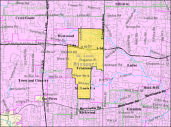
U.S. Census reference map.
Coordinates: 38°37′48″N90°25′08″W / 38.63000°N 90.41889°W / 38.63000; -90.41889 Coordinates: 38°37′48″N90°25′08″W / 38.63000°N 90.41889°W / 38.63000; -90.41889
Country United States
State Missouri
County St. Louis
Government
   Mayor Kate Hatfield
Area
[1]
  Total2.88 sq mi (7.46 km2)
  Land2.88 sq mi (7.46 km2)
  Water0.00 sq mi (0.00 km2)
Elevation
[2]
640 ft (200 m)
Population
 (2020)
  Total3,612
  Density1,253.73/sq mi (484.02/km2)
Time zone UTC-6 (Central (CST))
  Summer (DST) UTC-5 (CDT)
ZIP code
63131
Area code 314
FIPS code 29-26110 [3]
GNIS feature ID2394829 [2]
Website Frontenac, Missouri

Frontenac is a city in St. Louis County, Missouri, United States. The population was 3,612 at the 2020 census. [4]

Contents

The community name is inspired by the New France governor Louis de Buade de Frontenac. Benjamin and Lora Wood, who laid out the community's core called Frontenac Estates, that consisted of 26 two-acre estates, had made frequent trips to Quebec. The community was incorporated as 217 acres (88 ha) in 1947 and annexed another 967 acres (391 ha) in 1948. The community still consists mostly of houses on one-acre lots. French architecture is encouraged in design. [5] [6]

Geography

According to the United States Census Bureau, the city has a total area of 2.88 square miles (7.46 km2), all land. [7]

Demographics

Historical population
CensusPop.Note
1950 1,099
1960 3,089181.1%
1970 3,92026.9%
1980 3,654−6.8%
1990 3,374−7.7%
2000 3,4833.2%
2010 3,4820.0%
2020 3,6123.7%
U.S. Decennial Census [8]

2020 census

As of the 2020 census, there were 3,612 people and 1,305 households living in the city. The racial makeup of the city was 82.6% White (81.6% non-Hispanic White), 2.3% African American, 0.1% Native American, 9.3% Asian, 0.8% from other races, and 4.8% from two or more races. Hispanic or Latino of any race were 2.6% of the population. [4]

2010 census

As of the census [9] of 2010, there were 3,482 people, 1,267 households, and 1,036 families living in the city. The population density was 1,209.0 inhabitants per square mile (466.8/km2). There were 1,357 housing units at an average density of 471.2 per square mile (181.9/km2). The racial makeup of the city was 90.1% White, 2.6% African American, 0.1% Native American, 5.6% Asian, 0.3% from other races, and 1.2% from two or more races. Hispanic or Latino of any race were 1.5% of the population.

There were 1,267 households, of which 34.6% had children under the age of 18 living with them, 73.3% were married couples living together, 5.4% had a female householder with no husband present, 3.0% had a male householder with no wife present, and 18.2% were non-families. 16.1% of all households were made up of individuals, and 8.6% had someone living alone who was 65 years of age or older. The average household size was 2.70 and the average family size was 3.03.

The median age in the city was 49.2 years. 24.9% of residents were under the age of 18; 5.3% were between the ages of 18 and 24; 13.1% were from 25 to 44; 35.5% were from 45 to 64; and 21.3% were 65 years of age or older. The gender makeup of the city was 47.6% male and 52.4% female.

Education

See also

Related Research Articles

<span class="mw-page-title-main">Daleville, Indiana</span> Town in Indiana, United States

Daleville is a town in Salem Township, Delaware County, Indiana, United States. The population was 1,651 at the 2020 census. It is part of the Muncie, IN Metropolitan Statistical Area.

<span class="mw-page-title-main">Evansdale, Iowa</span> City in Iowa, United States

Evansdale is a city in Black Hawk County, Iowa, United States. The population was 4,561 in the 2020 census, an increase from 4,526 in 2000. It is part of the Waterloo–Cedar Falls Metropolitan Statistical Area.

<span class="mw-page-title-main">La Porte City, Iowa</span> City in Iowa, United States

La Porte City is a city in Black Hawk County, Iowa, United States. The population was 2,284 at the 2020 census. It is part of the Waterloo–Cedar Falls Metropolitan Statistical Area.

<span class="mw-page-title-main">Anita, Iowa</span> City in Iowa, United States

Anita is a city in Cass County, Iowa, United States, platted in 1869 and incorporated in 1875. The population was 963 at the 2020 census. Lake Anita State Park is located just outside the town.

<span class="mw-page-title-main">Robins, Iowa</span> City in Iowa, United States

Robins is a city in Linn County, Iowa, United States. The population was 3,353 at the time of the 2020 census. It is a suburb of Cedar Rapids and part of the Cedar Rapids Metropolitan Statistical Area.

<span class="mw-page-title-main">Colo, Iowa</span> City in Iowa, United States

Colo is a city in Story County, Iowa, United States. The population was 845 at the 2020 census. It is part of the Ames, Iowa Metropolitan Statistical Area, which is a part of the larger Ames-Boone, Iowa Combined Statistical Area.

<span class="mw-page-title-main">Frontenac, Kansas</span> City in Crawford County, Kansas

Frontenac is the second largest city in Crawford County, Kansas, United States. As of the 2020 census, the population of the city was 3,382.

<span class="mw-page-title-main">Colwich, Kansas</span> City in Sedgwick County, Kansas

Colwich is a city in Sedgwick County, Kansas, United States, located northwest of Wichita. As of the 2020 census, the population of the city was 1,455.

<span class="mw-page-title-main">Breezy Point, Minnesota</span> City in Minnesota, United States

Breezy Point is a city in Crow Wing County, Minnesota, United States. It is part of the Brainerd Micropolitan Statistical Area. The population was 2,346 at the 2010 census.

<span class="mw-page-title-main">Senatobia, Mississippi</span> City in Mississippi, United States

Senatobia is a city in, and the county seat of, Tate County, Mississippi, United States, and is the 16th largest municipality in the Memphis Metropolitan Area. The population was 8,165 at the 2010 census.

<span class="mw-page-title-main">Gainesville, Missouri</span> City in Missouri, United States

Gainesville is a city in Ozark County, Missouri, United States. The population was 745 at the 2020 census. It is the county seat of Ozark County.

<span class="mw-page-title-main">Brentwood, Missouri</span> City in Missouri, United States

Brentwood is an inner-ring suburb of St. Louis, located in St. Louis County, Missouri, United States. The population was 8,233 at the 2020 census.

<span class="mw-page-title-main">Huntleigh, Missouri</span> City in Missouri, United States

Huntleigh is a city in St. Louis County, Missouri, United States. The population was 334 at the 2010 census.

<span class="mw-page-title-main">Pleasant Valley, Missouri</span> Place in Missouri, United States

Pleasant Valley is a city in Clay County, Missouri, United States. The population was 2,743 at the 2020 census. It is part of the Kansas City metropolitan area.

<span class="mw-page-title-main">Williston Park, New York</span> Village in New York, United States

Williston Park is an incorporated village in the Town of North Hempstead in Nassau County, on Long Island, in New York, United States. The population was 7,287 at the 2010 census.

<span class="mw-page-title-main">Forest Park, Ohio</span> City in Ohio, United States

Forest Park is the second most populous city in Hamilton County, Ohio, United States. It is a suburb of Cincinnati. The population was 20,189 at the 2020 census.

<span class="mw-page-title-main">Jackson, Ohio</span> City in Ohio, United States

Jackson is a city in and the county seat of Jackson County, Ohio, United States approximately 27 mi (43 km) SE of Chillicothe. The population was 6,239 at the 2020 census.

<span class="mw-page-title-main">Royal City, Washington</span> City in Washington, United States

Royal City is a city in Grant County, Washington, United States. The population was 1,776 at the 2020 census.

<span class="mw-page-title-main">Ranson, West Virginia</span> City in West Virginia, United States

Ranson is a city in Jefferson County, West Virginia, United States. The population was 5,433 at the 2020 census. It is part of the northwestern fringes of the Washington metropolitan area.

<span class="mw-page-title-main">Star Valley Ranch, Wyoming</span> Town in Wyoming, United States

Star Valley Ranch is a town in Lincoln County, Wyoming, United States. The population was 1,503 at the 2010 census. It was incorporated on November 8, 2005; at the 2000 census, it was only a census-designated place (CDP).

References

  1. "ArcGIS REST Services Directory". United States Census Bureau. Retrieved August 28, 2022.
  2. 1 2 U.S. Geological Survey Geographic Names Information System: Frontenac, Missouri
  3. "U.S. Census website". United States Census Bureau . Retrieved 2008-01-31.
  4. 1 2 "United States Census Bureau" . Retrieved February 5, 2021.
  5. "Home / Frontenac, MO".
  6. "Archived copy" (PDF). Archived from the original (PDF) on 2011-07-25. Retrieved 2010-12-25.{{cite web}}: CS1 maint: archived copy as title (link)
  7. "US Gazetteer files 2010". United States Census Bureau. Archived from the original on 2012-07-02. Retrieved 2012-07-08.
  8. "Census of Population and Housing". Census.gov. Retrieved June 4, 2015.
  9. "U.S. Census website". United States Census Bureau . Retrieved 2012-07-08.