Velda Village Hills, Missouri

Last updated
Velda Village Hills, Missouri
St. Louis County Missouri Incorporated and Unincorporated areas Velda Village Hills Highlighted.svg
Location of Velda Village_Hills, Missouri
Coordinates: 38°41′32″N90°17′16″W / 38.69222°N 90.28778°W / 38.69222; -90.28778
Country United States
State Missouri
County St. Louis
Area
[1]
  Total0.12 sq mi (0.31 km2)
  Land0.12 sq mi (0.31 km2)
  Water0.00 sq mi (0.00 km2)
Elevation
[2]
571 ft (174 m)
Population
 (2020)
  Total881
  Density7,341.67/sq mi (2,835.93/km2)
Time zone UTC-6 (Central (CST))
  Summer (DST) UTC-5 (CDT)
ZIP code
63121 [3]
Area code 314
FIPS code 29-75814 [4]
GNIS feature ID2400050 [2]

Velda Village Hills is a city in northeastern St. Louis County, Missouri, United States. [5] [6] The population was 1,055 at the 2010 census. [7]

Contents

Geography

Velda Village Hills is located at 38°41′32″N90°17′13″W / 38.69222°N 90.28694°W / 38.69222; -90.28694 (38.692351, -90.286987). [8]

According to the United States Census Bureau, the village has a total area of 0.12 square miles (0.31 km2), all land. [9]

Velda Village Hills is one of the most densely populated communities in Missouri, with a density of nearly 9,000 people per square mile.

Demographics

2010 census

Historical population
CensusPop.Note
1950 1,527
1960 1,365−10.6%
1970 1,205−11.7%
1980 1,43218.8%
1990 1,315−8.2%
2000 1,090−17.1%
2010 1,055−3.2%
2020 881−16.5%
U.S. Decennial Census [10]

As of the census [11] of 2010, there were 1,055 people, 427 households, and 295 families living in the village. The population density was 8,791.7 inhabitants per square mile (3,394.5/km2). There were 465 housing units at an average density of 3,875.0 per square mile (1,496.1/km2). The racial makeup of the village was 0.9% White, 98.5% African American, and 0.7% from two or more races.

There were 427 households, of which 29.5% had children under the age of 18 living with them, 25.8% were married couples living together, 35.1% had a female householder with no husband present, 8.2% had a male householder with no wife present, and 30.9% were non-families. 26.9% of all households were made up of individuals, and 9.1% had someone living alone who was 65 years of age or older. The average household size was 2.47 and the average family size was 2.97.

The median age in the village was 44.2 years. 21.8% of residents were under the age of 18; 7.6% were between the ages of 18 and 24; 21.7% were from 25 to 44; 28.8% were from 45 to 64; and 20% were 65 years of age or older. The gender makeup of the village was 42.4% male and 57.6% female.

2000 census

As of the census [4] of 2000, there were 1,090 people, 428 households, and 314 families living in the village. The population density was 9,235.6 inhabitants per square mile (3,565.9/km2). There were 451 housing units at an average density of 3,821.3 per square mile (1,475.4/km2). The racial makeup of the village was 1.38% White, 98.35% African American, 0.18% Pacific Islander, and 0.09% from two or more races. Hispanic or Latino of any race were 0.37% of the population.

There were 428 households, out of which 23.4% had children under the age of 18 living with them, 36.0% were married couples living together, 31.3% had a female householder with no husband present, and 26.6% were non-families. 23.4% of all households were made up of individuals, and 7.7% had someone living alone who was 65 years of age or older. The average household size was 2.55 and the average family size was 2.99.

In the village, the population was spread out, with 23.9% under the age of 18, 7.4% from 18 to 24, 23.0% from 25 to 44, 30.9% from 45 to 64, and 14.7% who were 65 years of age or older. The median age was 42 years. For every 100 females, there were 79.6 males. For every 100 females age 18 and over, there were 77.1 males.

The median income for a household in the village was $38,173, and the median income for a family was $40,357. Males had a median income of $30,074 versus $23,355 for females. The per capita income for the village was $18,649. About 8.6% of families and 8.8% of the population were below the poverty line, including 10.9% of those under age 18 and 11.9% of those age 65 or over.

Police services

Police service is provided by contract with the North County Police Cooperative.

Related Research Articles

<span class="mw-page-title-main">Oak Park, Indiana</span> CDP in Indiana, United States

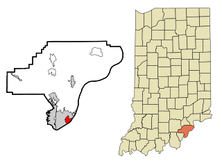
Oak Park is a census-designated place (CDP) in Clark County, Indiana, United States. The population was 5,379 at the 2000 census.

<span class="mw-page-title-main">Brownsboro Village, Kentucky</span> City in Kentucky, United States

Brownsboro Village is a home rule-class city in Jefferson County, Kentucky, United States. The population was 319 at the 2010 census.

<span class="mw-page-title-main">Trail, Minnesota</span> City in Minnesota, United States

Trail is a city in Polk County, Minnesota, United States. It is part of the Grand Forks, ND-MN Metropolitan Statistical Area. The population was 40 at the 2020 census.

<span class="mw-page-title-main">Cedar Hill Lakes, Missouri</span> Village in Missouri, United States

Cedar Hill Lakes is a village in Jefferson County, Missouri, United States. The population was 203 at the 2020 census.

<span class="mw-page-title-main">Hillsdale, Missouri</span> Village in Missouri, United States

Hillsdale is a village in St. Louis County, Missouri, United States. The population was 1,478 at the 2010 census.

<span class="mw-page-title-main">Mackenzie, Missouri</span> Village in Missouri, United States

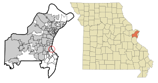
Mackenzie is an unincorporated community in St. Louis County, Missouri, United States. The population was 134 at the 2010 census.

<span class="mw-page-title-main">Velda City, Missouri</span> City in Missouri, United States

Velda City is a city in St. Louis County, Missouri, United States. The population was 1,420 at the 2010 census.

<span class="mw-page-title-main">Lonepine, Montana</span> CDP in Montana, United States

Lonepine is a census-designated place (CDP) in Sanders County, Montana, United States. The population was 137 at the 2000 census.

<span class="mw-page-title-main">Baldwin Park, Missouri</span> Village in Missouri, United States

Baldwin Park is a village in Cass County, Missouri, United States. The population was 92 at the 2010 census. It is part of the Kansas City metropolitan area.

<span class="mw-page-title-main">Hanley Hills, Missouri</span> Village in Missouri, United States

Hanley Hills is a village in St. Louis County, Missouri, United States. The population was 2,101 at the 2010 census.

<span class="mw-page-title-main">Wynantskill, New York</span> CDP in New York, United States

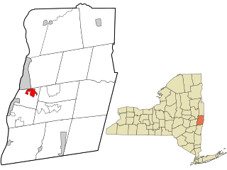
Wynantskill is a census-designated place (CDP) in Rensselaer County, New York, United States. The population was 3,276 at the 2010 census. Wynantskill is located at the northern town line and the northeastern corner of the town of North Greenbush. The community is a suburb of Troy. state route 66 is the main route through the community. Wynantskill has a major grocery store, several banks and restaurants, a craft beverage store, convenience stores, a post office, and a bowling alley, with almost all houses located on side streets off Main Ave. Other major roads are Whiteview Road, a primarily residential road that leads to US 4; and West Sand Lake Road.

<span class="mw-page-title-main">Highland Hills, Ohio</span> Village in Ohio, United States

Highland Hills is a village in Cuyahoga County, Ohio, United States. The population was 662 at the 2020 census. It was formally incorporated in 1990.

<span class="mw-page-title-main">Waite Hill, Ohio</span> Village in Ohio, United States

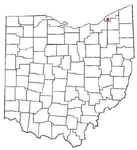
Waite Hill is a village in Lake County, Ohio, United States and a rural suburb of Cleveland. The population was 543 at the 2020 census.

<span class="mw-page-title-main">Hanging Rock, Ohio</span> Village in Ohio, United States

Hanging Rock is a village in Lawrence County, Ohio, United States, along the Ohio River. The population was 221 at the 2010 census. It is regularly labeled a speed trap; the village earned revenues of $109,186 in mayor's court receipts in 2000, compared with $3,106 in property taxes.

<span class="mw-page-title-main">Pleasant Hill, Ohio</span> Village in Ohio, United States

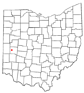
Pleasant Hill is a village in Miami County, Ohio, United States. The population was 1,200 at the 2010 census. It is part of the Dayton Metropolitan Statistical Area.

<span class="mw-page-title-main">East Canton, Ohio</span> Village in Ohio, United States

East Canton is a village in central Stark County, Ohio, United States. The population was 1,521 at the 2020 census. It is part of the Canton–Massillon metropolitan area.

<span class="mw-page-title-main">Slaughterville, Oklahoma</span> Town in Oklahoma, United States

Slaughterville is a town in Cleveland County, Oklahoma, United States, and located in the Oklahoma City metropolitan area. As of the 2020 census, the city population was 4,163, a 0.6% increase from 2010.

<span class="mw-page-title-main">Weyers Cave, Virginia</span> CDP in Virginia, United States

Weyers Cave is a census-designated place (CDP) in Augusta County, Virginia, United States. The population was 2,473 at the 2010 census. It is part of the Staunton–Waynesboro Micropolitan Statistical Area.

<span class="mw-page-title-main">Tulalip Bay, Washington</span> Former CDP in Washington, United States

Tulalip Bay is a former census-designated place (CDP) in western Snohomish County, Washington, United States. The population was 1,561 at the 2000 census. The CDP was discontinued at the 2010 census. It is the largest community within the reservation of the federally recognized Tulalip Tribes of Washington.

<span class="mw-page-title-main">Eau Galle, Dunn County, Wisconsin</span> Town in Wisconsin, United States

The Town of Eau Galle is located in Dunn County, Wisconsin, United States. The population was 797 at the 2000 census. The unincorporated community of Eau Galle and the ghost town of Welch Point are located in the town.

References

  1. "ArcGIS REST Services Directory". United States Census Bureau. Retrieved August 28, 2022.
  2. 1 2 U.S. Geological Survey Geographic Names Information System: Velda Village Hills, Missouri
  3. "Velda Village Hills MO ZIP Code". zipdatamaps.com. 2023. Retrieved June 16, 2023.
  4. 1 2 "U.S. Census website". United States Census Bureau . Retrieved 2008-01-31.
  5. "Cumulative Results Report, General Municipal Election" (PDF). St. Louis County. April 5, 2022.
  6. "Race". United States Census Bureau. 2020.
  7. "Race, Hispanic or Latino, Age, and Housing Occupancy: 2010 Census Redistricting Data (Public Law 94-171) Summary File (QT-PL), Velda Village Hills village, Missouri". United States Census Bureau . Retrieved October 26, 2011.
  8. "US Gazetteer files: 2010, 2000, and 1990". United States Census Bureau. 2011-02-12. Retrieved 2011-04-23.
  9. "US Gazetteer files 2010". United States Census Bureau. Archived from the original on 2012-07-02. Retrieved 2012-07-08.
  10. "Census of Population and Housing". Census.gov. Retrieved June 4, 2015.
  11. "U.S. Census website". United States Census Bureau . Retrieved 2012-07-08.