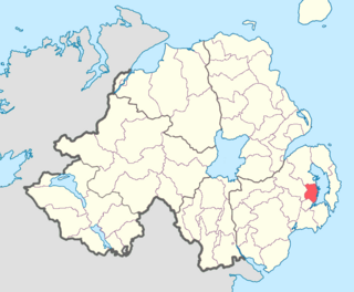
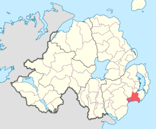
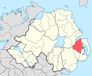
Dufferin is a historic barony in County Down, Northern Ireland. It is on the southern half of the west shore of Strangford Lough, and is bordered by three other baronies: Castlereagh Lower to the north; Castlereagh Upper to the west; and Lecale Lower to the south.

Belfast Upper is a barony in County Antrim, Northern Ireland. To its east lies the barony of Belfast and Belfast Lough, and it is bordered by five other baronies: Belfast Lower to the north-east; Antrim Upper to the north-west; Massereene Lower to the west; Massereene Upper to the south-west; and Castlereagh Upper to the south. The Forth River flows through both Belfast Upper and Lower. The most prominent hills in the barony are Black Hill and Lyle's Hill.
Massereene Upper is a barony in southwest County Antrim, Northern Ireland. It roughly matches the former district of Killultagh. It includes settlements such as Crumlin, Glenavy, Lower Ballinderry, Maghaberry and Aghalee. To its east lies Belfast Lough, and it is bordered by four other baronies: Massereene Lower to the north; Belfast Upper to the east; Castlereagh Upper to the south-east; and Iveagh Lower, Lower Half to the south-west.

Oneilland West is a barony in County Armagh, Northern Ireland. It is also called Clancann, after the Mac Cana clan. It lies in the north of the county on the south-western shore of Lough Neagh and the border of County Tyrone. Oneilland West is bordered by five other baronies: Armagh to the west; Dungannon Middle to the north-west; Oneilland East to the north-east; Orior Lower to the south-east; and Kinelarty to the south.
Oneilland East is a barony in the north-east of County Armagh, Northern Ireland. It is also called Clanbrasil. It lies in the north-east corner of the county, on the south-eastern shore of Lough Neagh and the boundary with County Down. Oneilland East is bordered by three other baronies: Oneilland West to the west; Iveagh Lower to the east; and Orior Lower to the south.

Orior Lower is a barony in County Armagh, Northern Ireland. It lies in the east of the county and borders County Down with its eastern boundary. It is bordered by seven other baronies: Fews Upper to the south-west; Fews Lower to the west; Oneilland West to the north-west; Oneilland East to the north; Iveagh Lower, Lower Half to the north-east; Iveagh Upper, Upper Half to the east; and Orior Upper to the south. A small enclave of Orior Lower resides in the east of Orior Upper.

Orior Upper is a barony in County Armagh, Northern Ireland. It lies in the south-east of the county and borders the Republic of Ireland with its southern boundary. It is bordered by five other baronies in Northern Ireland: Fews Upper and an enclave of Fews Lower to the west; Orior Lower to the north; Iveagh Upper, Upper Half to its west, which is divided in two by the Lordship of Newry. It also borders two baronies in the Republic of Ireland: Dundalk Lower and Dundalk Upper to the south.
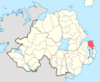
Ards Lower, alternatively known as North Ards, is a barony in County Down, Northern Ireland. It lies on the northern half of the Ards Peninsula in the north-east of the county, with the Irish Sea to its east and Strangford Lough to its south-west. It is bordered by two other baronies: Ards Upper to the south; and Castlereagh Lower to the west.

Lecale Lower is a barony in County Down, Northern Ireland. It lies to the east of the county with Strangford Lough to its north and the Irish Sea to its right. It is bordered by five other baronies: Lecale Upper to the south; Ards Upper to the north-east just across the mouth of Strangford Lough; Dufferin to the north; Castlereagh Upper to the north-west; and Kinelarty to the west.
Lecale Upper is a barony in County Down, Northern Ireland. To its south lies the Irish Sea, and it is bordered by three other baronies; Lecale Lower and Kinelarty to the north; and Iveagh Upper, Lower Half to the west.

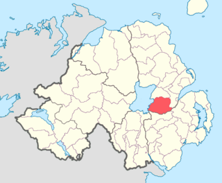
Kinelarty is a former Irish district and barony in County Down, Northern Ireland. It lies east of the centre of the county, and is bordered by five other baronies: Iveagh Upper, Lower Half to the west; Lecale Upper to the south and south-east; Lecale Lower to the east; Castlereagh Upper to the north; and Iveagh Lower, Upper Half to the north-west.

Iveagh Upper, Lower Half is the name of a barony in County Down, Northern Ireland. It was created by 1851 with the division of the barony of Iveagh Upper into two. It lies in the centre of the county, and is bordered by six other baronies: Iveagh Upper, Upper Half and Lordship of Newry to the west; Mourne to the south; Kinelarty and Lecale Upper to the east; and Iveagh Lower, Upper Half to the north.

Iveagh Upper, Upper Half is the name of a barony in County Down, Northern Ireland. It was created by 1851 with the division of the barony of Iveagh Upper into two. It lies to the west and south of the county, split in half by the Lordship of Newry. It is bordered by six other baronies: Mourne to the south; Iveagh Upper, Lower Half to the east; Iveagh Lower, Lower Half and Iveagh Lower, Upper Half to the north; and Orior Lower and Orior Upper to the west.

Iveagh Lower, Upper Half is a barony in County Down, Northern Ireland. It was created by 1851 with the division of the barony of Iveagh Lower into two. It is bordered by five other baronies: Iveagh Upper, Lower Half to the south; Iveagh Upper, Upper Half to the south-west; Iveagh Lower, Lower Half to the west and north; Castlereagh Upper to the north-east; and Kinelarty to the west.

Iveagh Lower, Lower Half is the name of a barony in County Down, Northern Ireland. It was created by 1851 with the division of the barony of Iveagh Lower into two. It is bordered by six other baronies: Massereene Upper to the north; Castlereagh Upper to the east; Iveagh Lower, Upper Half and Iveagh Upper, Upper Half to the south; Oneilland East and Orior Lower to the west.

Kilmore is a village, civil parish and townland of 149 acres (60 ha) in County Down, Northern Ireland, about 1 mile (1.6 km) from Crossgar. It is situated in the historic baronies of Castlereagh Upper and Kinelarty.

Castlereagh Lower is a historic barony in County Down, Northern Ireland. It was created by 1841 with the division of Castlereagh into two. The barony roughly matches the former Gaelic territory of Uí Blathmaic, anglicized Blathewic. It is bordered by three other baronies: Ards Lower to the east; Dufferin to the south; and Castlereagh Upper to the west and south-west. Castlereagh Lower is also bounded by Belfast Lough to the north and Strangford Lough to the south-east.

Blaris is a civil parish covering areas of both County Antrim and County Down, Northern Ireland. It is situated in the historic baronies of Castlereagh Upper and Iveagh Lower, Upper Half in County Down and Massereene Upper in County Antrim. It is also a townland of 543 acres, which contains the site of the Blaris medieval parish church, and is on the south-east side of the River Lagan, adjacent to Lisburn.
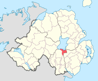
Castlereagh is the name of a former barony in County Down, present-day Northern Ireland. It spanned the north-eastern area of the county bordering the baronies of: Ards to the east; Belfast to the north; Iveagh to the west south; and Dufferin, Kinelarty, and Lecale to the south. By 1841 the barony was divided into Castlereagh Lower and Castlereagh Upper.

