
County Down is one of the six counties of Northern Ireland, one of the nine counties of Ulster and one of the traditional thirty-two counties of Ireland. It covers an area of 961 sq mi (2,490 km2) and has a population of 552,261. It borders County Antrim to the north, the Irish Sea to the east, County Armagh to the west, and County Louth across Carlingford Lough to the southwest.

Warrenpoint is a small port town and civil parish in County Down, Northern Ireland. It sits at the head of Carlingford Lough, south of Newry, and is separated from the Republic of Ireland by a narrow strait. The town is beside the village of Rostrevor and is overlooked by the Mournes and Cooley Mountains. Warrenpoint sprang up within the townland of Ringmackilroy, and is locally nicknamed "The Point", which also represents the town's full name in Irish, An Pointe".

Rostrevor is a village and townland in County Down, Northern Ireland. It lies at the foot of Slieve Martin on the coast of Carlingford Lough, near Warrenpoint. The Kilbroney River flows through the village and Rostrevor Forest is nearby. 7.5 miles (12 km) south-east of Newry, the village is within the Newry, Mourne and Down local government district.
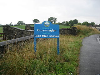
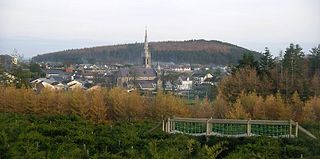
Crossmaglen is a village and townland in County Armagh, Northern Ireland. It had a population of 1,610 in the 2011 Census and is the largest village in South Armagh. The village centre is the site of a large Police Service of Northern Ireland base and formerly of an observation tower.
Castlewellan is a small town in County Down, in the south-east of Northern Ireland close to the Irish Sea. It is beside Castlewellan Lake and Slievenaslat mountain, 11 miles (18 km) southwest of Downpatrick. It lies between the Mourne Mountains and Slieve Croob. It had a population of 2,782 people in the 2011 census.

Drumaness is a village and townland in the Newry, Mourne and Down District Council area of County Down, Northern Ireland. It is 3 miles or 5 kilometres south of Ballynahinch, beside the main A24 Belfast to Newcastle road. It is situated in the civil parish of Magheradroll and the historic barony of Kinelarty. In the 2011 census it had a population of 1,339 people.
Leitrim, is a small village in County Down, Northern Ireland, approximately 3 miles from Castlewellan, near Dromara, in the parish of Drumgooland. It is set between the Dromara Hills and the Mourne Mountains. It is claimed to be home to the MacCartan clan of Kinelarty.

Belleeks is a small village and townland in south County Armagh, Northern Ireland. In the 2011 Census it had a reported population of 375. It lies within the Newry, Mourne and Down District Council area and the historic barony of Upper Fews.

Lislea is a small village and townland near Slieve Gullion in County Armagh, Northern Ireland. It is within the civil parish of Killevy and the historic barony of Orior Upper. Today it is within the Newry, Mourne and Down District Council area. It borders the townlands of Ballard, Carricnagalliagh, Aghmakane, Duburren and Drumilly. In the 2001 Census it had a population of 84 people.
St Peter's GAA is a Gaelic Athletic Association club in Warrenpoint, County Down, Northern Ireland.

Clonduff GAC is a Gaelic Athletic Association club, based in Hilltown County Down, Northern Ireland. It represents the 2 areas that make up the Clonduff parish, namely Hilltown and Cabra.

Banbridge is a town in County Down, Northern Ireland. It lies on the River Bann and the A1 road and is named after a bridge built over the Bann in 1712. It is in the civil parish of Seapatrick and the historic barony of Iveagh Upper, Upper Half. The town began as a coaching stop on the road from Belfast to Dublin and thrived from Irish linen manufacturing. The town was home to the headquarters of the former Banbridge District Council. Following a reform of local government in Northern Ireland in 2015, Banbridge became part of Armagh City, Banbridge and Craigavon Borough Council. It had a population of 17,400 in the 2021 census.

Kilcoo is a small village and civil parish in County Down, Northern Ireland. It lies between Rathfriland and Castlewellan and is within the Newry, Mourne and Down District Council area. The village is on the A25 Dublin Road 6 kilometres (4 mi) south-west of Castlewellan. Kilcoo had a population 1415 people in the 2001 Census.
Kilcoo Owen Roes is a Gaelic Athletic Association club from Kilcoo, County Down, Northern Ireland.
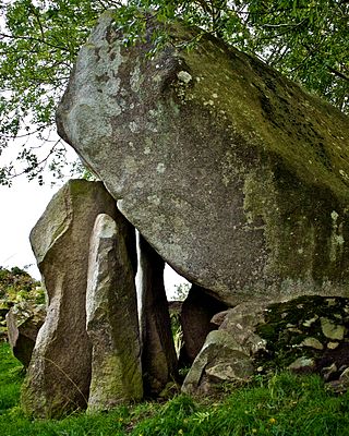
Goward Dolmen is a megalithic dolmen or cromlech situated between Hilltown and Castlewellan in County Down, Northern Ireland, two miles from Hilltown. It is in a farmer's field in the townland of Goward, in the parish of Clonduff. It is known locally as Pat Kearney's Big Stone or Cloughmore Cromlech. The huge granite capstone has slipped from its original horizontal position.

Cabra is a large townland in County Down, Northern Ireland. It is in the parish of Clonduff and is situated approximately two miles from Hilltown, Rathfriland and Kilcoo. Cabra has a tradition of farming, with the three most common farming methods in Cabra being: sheep farming/breeding, crop growing and cow farming/breeding.

Iveagh Upper, Lower Half is the name of a barony in County Down, Northern Ireland. It was created by 1851 with the division of the barony of Iveagh Upper into two. It lies in the centre of the county, and is bordered by six other baronies: Iveagh Upper, Upper Half and Lordship of Newry to the west; Mourne to the south; Kinelarty and Lecale Upper to the east; and Iveagh Lower, Upper Half to the north.

Iveagh Upper, Upper Half is the name of a barony in County Down, Northern Ireland. It was created by 1851 with the division of the barony of Iveagh Upper into two. It lies to the west and south of the county, split in half by the Lordship of Newry. It is bordered by six other baronies: Mourne to the south; Iveagh Upper, Lower Half to the east; Iveagh Lower, Lower Half and Iveagh Lower, Upper Half to the north; and Orior Lower and Orior Upper to the west.
Clonduff is a civil parish in County Down, Northern Ireland. It is mainly in the historic barony of Iveagh Upper, Lower Half, with one townland in the barony of Iveagh Upper, Upper Half.


