Copeland Islands

Last updated

Copeland Islands
Oileáin Chóplainn
Copeland.Islands.ferry.2012.JPG
The Copeland Islands seen from a ferry
County Down UK location map.svg
Red pog.svg
Copeland Islands
Relief Map of Northern Ireland.png
Red pog.svg
Copeland Islands
Island of Ireland relief location map.png
Red pog.svg
Copeland Islands
EtymologyNamed from the de Coupland family, or from Old Norse Kaupmanneyjar, "merchant islands"
Geography
Location North Channel
Coordinates 54°40′29″N5°31′44″W / 54.6746°N 5.5289°W / 54.6746; -5.5289
Archipelago Offshore islands of Ireland
Total islands3
Major islandsLighthouse Island, Copeland Island, Mew Island
Area392.25 acres (158.74 ha) [1]
Administration
Constituent country Northern Ireland
County County Down
Demographics
Population0
Additional information
Time zone
  Summer (DST)

The Copeland Islands is a group of three islands in the north Irish Sea, north of Donaghadee, County Down, Northern Ireland, consisting of Lighthouse Island (also known as Old Island), Copeland Island (also known as Big Island) and Mew Island. They lie within the civil parish of Bangor. [2]

Contents

Along with Lambay Island and Ireland's Eye off County Dublin, the islands are the only other one of the 258 sometime inhabited islands of Ireland which lie on the east coast. [3]

Etymology

The Copeland Islands most likely derive their name from the de Coupland family, who settled in the Newtownards area, at the northern end of the Ards Peninsula, along with other Normans in the 12th century. [2] This family also lent their name to other landmarks in the vicinity such as Copeland Water near Carrickfergus and the townland of Ballycopeland in the civil parish of Donaghadee. [2]

The earliest possible recorded name for the islands, however, may be the Old Norse Kaupmanneyjar (kaupmann meaning 'merchant' and ey meaning 'island'), recorded in the Norse Hakonar Saga Gamla , and dated to 1230. [2] It has been suggested that 'Kaupmann' developed into 'Copman' and then into 'Copeland', with the form 'Copman' recorded several times in the late 16th century in reference to the islands. [2]

The original Irish name for the islands is unknown. However, it has been suggested that the 1570s usage of 'Helaine Harr[o]n[e]' may be an attempt at Anglicising the Irish name Oileáin Árann (island of the (kidney-shaped) ridge). [2] The modern Irish name, however, is a Gaelicisation of Copeland Islands into Oileáin Chóplainn. [2] [4]

History

The old kirkyard (graveyard) on Copeland Island, also known as Big Island. Old graveyard, Copeland Island - geograph.org.uk - 209117.jpg
The old kirkyard (graveyard) on Copeland Island, also known as Big Island.

There are three islands included in the Copeland Islands: the Great Copeland Island (also known as Big Island or Copeland Island), the Lighthouse Island (also known as Old Island, which does not have a lighthouse now), and Mew Island, which does have a lighthouse. Over a century ago, Lighthouse Island had a population of about 100, including a school master with 28 pupils.

In 1671, James Ross obtained a fee farm grant of the islands, and in 1770 David Kerr bought them from The 2nd Earl of Clanbrassil (by the second creation). As the islands were a danger to ships, a light beacon was made on Lighthouse Island (also known as Old Island or Cross Island) in about 1715; it burned over 400 tons of coal every year. In 1796, the new British and Irish Lighthouse Board announced the erection of oil lamps and, in 1813, the new lighthouse was built. In 1884, a new lighthouse was built on Mew Island. In 1954, the Bird Observatory was established by Arnold Benington. [5]

Hans Sloane visited the islands and noted how how the sea wrens [ sic ] laid their eggs on the ground so thick that they had difficulty in passing along without treading on them while the birds screamed overhead. [6]

Until the 20th century, the islands were used by smugglers who brought tobacco and spirits through the islands and into County Down. [2]

Area of Special Scientific Interest (ASSI)

Copeland Islands ASSI is located off the County Down coast of Northern Ireland and comprises The Great Copeland, Lighthouse Island and Mew Island. The islands are important sites for breeding seabirds and waders, in addition to their coastal plant communities and geological features. [7]

Big Copeland supports the most diverse range of habitats of the three islands. Communities influenced by the sea are found around the shore with maritime cliff vegetation and pockets of salt marsh also present. The centre of the island is occupied by semi-improved wet grassland with frequent areas of marsh. [7]

Flora

The vegetation on Light House Island consists of short rabbit grazed turf with large areas of rank bracken ( Pteridium aquilinum ) and Himalayan balsam ( Impatiens glandulifera ). [8] Notable species include English stonecrop ( Sedum anglicum ), rock sea-spurrey ( Spergularia rupicola ), [8] Scots lovage ( Ligusticum scoticum ) and sea purslane ( Halimione portulacoides ). Lighthouse Island represents the southern limit for Scots lovage in Europe and the northern limit for sea purslane in Ireland. Other plants on the islands include Hyacinthoides non-scripta , Hyacinthoides hispanica , Dactylorhiza purpurella and Centaurium erythraea . [9] [7]

Mew Island is dominated by rank stands of grass and bracken but, as on all the islands, notable areas of inter-tidal and exposed rock habitat are present. [7]

Algae

The marine algae of the Lighthouse Island and the Mew Islands was studied in 1975 and the 56 species, or genera, identified were listed and published. [10]

Lichens

Nineteen species of lichens were collected in 1984, the identifications were confirmed or corrected by Dr A Fletcher. As far as is known these are the only records of lichens from the Lighthouse Island. [11]

Fauna

The islands are internationally important sites for breeding populations of Manx shearwater and Arctic tern and nationally important sites for breeding Mediterranean gull, common gull and common eider. The Manx shearwater colony on Copeland Islands holds more than 1.7% of the world population. The colony is in excess of four thousand pairs. The rabbit populations on the islands play an important role in the breeding success of the Manx shearwater as the latter mainly nest in the rabbit burrows that honeycomb the islands. Grazing by rabbits maintains a short sward, which is desirable for the fledglings. [7]

Great Copeland has an internationally important Arctic tern colony, with some 550 pairs. The site now represents the largest colony for this species in Ireland. Mew Island has been an important tern colony in the past and it is hoped that positive management will encourage terns to become re-established. The islands are the most important breeding sites in Northern Ireland for common gull with over 250 pairs present. Big Copeland has recently held Northern Ireland's first successful breeding pair of Mediterranean gull. The islands are home to a nationally important population of breeding eider duck. In total the three islands account for 14% of the Irish population. Non-breeding eider form part of the nationally important population that occurs along the Outer Ards coast and Belfast Lough areas. [7]

Other breeding colonies of note include black guillemot, water rail and stock dove. The latter species has suffered a dramatic decline in Northern Ireland, but numbers have increased on Copeland with some 100 pairs now breeding. Breeding waders such as lapwing and snipe may be found further inland. Here the taller vegetation, interspersed with open areas, provides an ideal breeding habitat. Birds of prey favour the islands when the breeding season is over. Hen harrier, sparrowhawk, buzzard, kestrel, merlin and peregrine falcon are all seen regularly. [7]

Mammals, such as the grey seal, common seal, harbour porpoise, bottlenose dolphin, common minke whale, common dolphin and otter have been reported from the Copeland Islands. [12]

Lepidoptera have also been recorded. 19 species of butterflies, 31 species of macro-Lepidoptera and three species of micro-Lepidoptera. [13]

A beetle new to Northern Ireland was recorded in 2013: Diplapion confluens (Kirby). [14]

Lighthouses

Mew Island Lighthouse Mew Island Lighthouse (2) - geograph.org.uk - 454449.jpg
Mew Island Lighthouse

A light station was established on Lighthouse Island in the early 18th century and a lighthouse built in 1815. It has been inactive since 1884, when the lighthouse was abandoned in favour of the Mew Island Lighthouse, but the ruined stump of the 16 m (52 ft) stone tower remains. The ruins of the keeper's house have been rebuilt to house a bird observatory. The island is now owned by the National Trust and operated by the volunteer members of the Copeland Bird Observatory. [15]

The Mew Island Lighthouse is currently active, and was converted to automatic operation with the lighthouse keepers permanently withdrawn in 1996. [16]

Princess Victoria ferry disaster

On 31 January 1953, Princess Victoria, a British Transport Commission ferry sailing from Stranraer to Larne, sank off the Copeland Islands in a heavy storm with the loss of 135 lives. [17]

See also

Related Research Articles

<span class="mw-page-title-main">Seabird</span> Birds that have adapted to life within the marine environment

Seabirds are birds that are adapted to life within the marine environment. While seabirds vary greatly in lifestyle, behaviour and physiology, they often exhibit striking convergent evolution, as the same environmental problems and feeding niches have resulted in similar adaptations. The first seabirds evolved in the Cretaceous period, and modern seabird families emerged in the Paleogene.

<span class="mw-page-title-main">Farne Islands</span> Island group off Northumberland, England

The Farne Islands are a group of islands off the coast of Northumberland, England. The group has between 15 and 20 islands depending on the level of the tide. They form an archipelago, divided into the Inner Group and the Outer Group. The main islands in the Inner Group are Inner Farne, Knoxes Reef, the East and West Wideopens, and the Megstone; the main islands in the Outer Group are Staple Island, Brownsman, North and South Wamses, Big Harcar, and Longstone. The two groups are separated by Staple Sound. The highest point, on Inner Farne, is 62 feet (19 m) above mean sea level.

<span class="mw-page-title-main">Shearwater</span> Seabird

Shearwaters are medium-sized long-winged seabirds in the petrel family Procellariidae. They have a global marine distribution, but are most common in temperate and cold waters, and are pelagic outside the breeding season.

<span class="mw-page-title-main">Great black-backed gull</span> Species of bird

The great black-backed gull is the largest member of the gull family. Described by the Cornell Lab of Ornithology as "the king of the Atlantic waterfront", it is a very aggressive hunter, pirate, and scavenger. It breeds on the European and North American coasts and islands of the North Atlantic and is fairly sedentary, though some move farther south or inland to large lakes or reservoirs. The adult great black-backed gull has a white head, neck and underparts, dark grey wings and back, pink legs and yellow bill.

<span class="mw-page-title-main">Manx shearwater</span> Species of bird

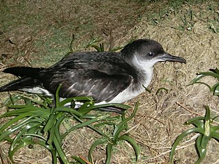
The Manx shearwater is a medium-sized shearwater in the seabird family Procellariidae. The scientific name of this species records a name shift: Manx shearwaters were called Manks puffins in the 17th century. Puffin is an Anglo-Norman word for the cured carcasses of nestling shearwaters. The Atlantic puffin acquired the name much later, possibly because of its similar nesting habits.

<span class="mw-page-title-main">Donaghadee</span> Human settlement in Northern Ireland

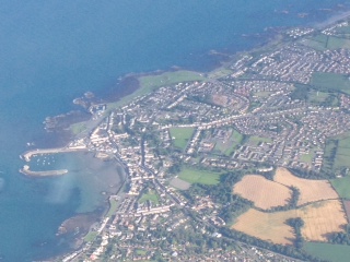
Donaghadee is a small town in County Down, Northern Ireland. It lies on the northeast coast of the Ards Peninsula, about 18 miles (29 km) east of Belfast and about six miles (10 km) south east of Bangor. It is in the civil parish of Donaghadee and the historic barony of Ards Lower. It had a population of 6,869 people in the 2011 Census.

<span class="mw-page-title-main">Skellig Islands</span> Two islands off the south-west coast of Ireland

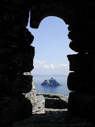
The Skellig Islands, once known as "the Skellocks", are two small, steep, and rocky islands lying about 13 km (8 mi) west of Bolus Head on the Iveragh Peninsula in County Kerry, Ireland. The larger of the two is Skellig Michael which, together with Little Skellig, is at the centre of a 364-hectare (899-acre) Important Bird Area established by BirdWatch Ireland in 2000. Skellig Michael is also famous for an early Christian monastery that is a UNESCO World Heritage Site.

<span class="mw-page-title-main">Skokholm</span> Small island in Wales

Skokholm or Skokholm Island is an island 2.5 miles (4.0 km) off the coast of Pembrokeshire, Wales, south of the neighbouring island of Skomer. The surrounding waters are a marine reserve and all are part of the Pembrokeshire Coast National Park. Both islands are listed as Sites of Special Scientific Interest.

<span class="mw-page-title-main">Skomer</span> Island in Pembrokeshire, Marloes and St Brides, Wales

Skomer or Skomer Island is an island off the coast of Pembrokeshire, in the community of Marloes and St Brides in west Wales. It is well known for its wildlife: around half the world's population of Manx shearwaters nest on the island, the Atlantic puffin colony is the largest in southern Britain, and the Skomer vole is unique to the island. Skomer is a national nature reserve, a Site of Special Scientific Interest and a Special Protection Area. It is surrounded by a marine nature reserve and is managed by the Wildlife Trust of South and West Wales.

Lady Isle is a small, uninhabited island, in the Firth of Clyde, Scotland. It was once home to a chapel dedicated to Saint Mary. The island features a lighthouse and a freshwater spring.

<span class="mw-page-title-main">The Skerries, Isle of Anglesey</span> Group of rocky islets in Wales

<span class="mw-page-title-main">Cemlyn Bay and lagoon</span> Site of Special Scientific Interest in Wales

Cemlyn Bay is a bay on the northwest coast of Anglesey, North Wales, approximately 2.5 km west of Wylfa nuclear power station, within the community of Cylch-y-Garn.

<span class="mw-page-title-main">Eclipse Island (Western Australia)</span> Island in Western Australia

Eclipse Island is a barren island in Western Australia, 17 kilometres (10.6 mi) due south of Albany, and 6.1 km (3.8 mi) south of the nearest point of the mainland coast, which is Cave Point on the southern coast of Torndirrup Peninsula. Eclipse Island Lighthouse is located near the centre of the island. Nearby South West Island contains Western Australia's southernmost landmass.

<span class="mw-page-title-main">Annet, Isles of Scilly</span>

Annet is the second largest of the fifty or so uninhabited Isles of Scilly, 1 kilometre (0.62 mi) west of St Agnes with a length of 1 kilometre (0.62 mi) and approximately 22 hectares in area. The low-lying island is almost divided in two by a narrow neck of land at West Porth which can, at times, be covered by waves. At the northern end of the island are the two granite carns of Annet Head and Carn Irish and three smaller carns known as the Haycocks. The rocky outcrops on the southern side of the island, such as South Carn, are smaller. Annet is a bird sanctuary and the main seabird breeding site in Scilly.

The Five Islands Nature Reserve is a protected nature reserve located in the Tasman Sea, off the Illawarra east coast of the state of New South Wales, Australia. The 26-hectare (64-acre) reserve comprises five continental islands that are situated between 0.5 and 3.5 kilometres east of Port Kembla. The Five Islands are Flinders Islet, Bass Islet, Martin Islet, Big Island and Rocky Islet.

<span class="mw-page-title-main">Swan Island (Tasmania)</span> Island in Bass Strait, Tasmania

Swan Island, part of the Waterhouse Island Group, is a 239-hectare (590-acre) granite island situated in Banks Strait, part of Bass Strait, lying close to the north-eastern coast of Tasmania, Australia.

<span class="mw-page-title-main">Griffiths Island</span> Island in Victoria, Australia

Griffiths Island, sometimes incorrectly spelled as Griffith Island or Griffitts Island, lies at the mouth of the Moyne River next to, and within the bounds of, the town of Port Fairy, in the Western District of the state of Victoria in Australia. Griffiths now has no permanent inhabitants, but is connected to the mainland by a causeway and is accessible on foot. It forms part of the Port Fairy and Belfast Coastline Protection Reserve and, as well as being a tourist attraction, is an important site in the context of the history of European settlement of western Victoria. It is managed by the Moyne Shire Council.

<span class="mw-page-title-main">Penguin Island (South Australia)</span> Island in South Australia

Penguin Island is an island in the Australian state of South Australia located in Rivoli Bay on the state's south east coast of approximately 1.5 kilometres south of Beachport. From 1878 to 1960, it was the site of an operating lighthouse. Since at least 1972, it has been part of the Penguin Island Conservation Park.

<span class="mw-page-title-main">Mew Island Lighthouse</span> Lighthouse in Northern Ireland

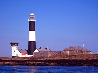
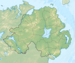
Mew Island Lighthouse is an active lighthouse within the Copeland Islands of County Down in Northern Ireland. The current 19th-century tower is the most recent in a series of lighthouses that have been built in the islands, which have helped to guide shipping around the archipelago and into Belfast Lough.

References

  1. "Copeland Island Townland, Co. Down". www.townlands.ie.
  2. 1 2 3 4 5 6 7 8 Hughes, AJ; Hannan, RJ (1992). Place-Names of Northern Ireland. Vol. Two, County Down II, The Ards. Belfast: The Queen's University of Belfast. ISBN   085389-450-7.
  3. Royle, SA (1994). "Island Life off County Down:The Copeland Islands". Ulster Journal of Archaeology. Third Series. 57: 177–182. JSTOR   20568216.
  4. "Copeland Islands". logainm.ie. Retrieved 19 June 2020.
  5. Deane, C (1983) "Copeland Islands" in "The Ulster Countryside" Century Books
  6. Hayes, Maurice (2022). "The Hans Sloane Memorial, Killyleagh". Lecale Review (20).
  7. 1 2 3 4 5 6 7 "Copeland Islands ASSI". Department of Agriculture, Environment and Rural Affairs. 18 July 2017. Retrieved 11 December 2021.PD-icon.svg This article incorporates text from this source, which is in the public domain .
  8. 1 2 Hackney, P (ed.). Stewart & Corry's Flora of the North-east of Ireland. Belfast: Institute of Irish Studies, The Queen's University of Belfast. ISBN   0-85389-446-9. (HB)
  9. anon. 2010. Annual Report for 2010. Copeland Bird Observatory 2010
  10. Morton, O, 1976 Copeland Islands Bird Observatory Report
  11. Morton, O, 1988. Lichens on Lighthouse Island. Copeland Bird Observatory Annual Report for 1986 page 44
  12. McKee, N, Mammal Report in Wolsey, S, (ed) 2012. Copeland Bird Observatory Annual Report 2010
  13. Lyons, J, 2009 in Wolsey, S. (ed) 2012. Copeland Bird Observatory Annual Report 2010
  14. Reid, CAM, 2015. Diplapion confluens (Kirby) (Coleoptera: Brentidae), new for Northern Ireland, at Lighthouse Island, County Down, with notes on other insects at this locality. Irish Naturalists' Journal.34: 135–136
  15. "Copeland Bird Observatory" . Retrieved 29 July 2019.
  16. "Mew Island". Commissioners of Irish Lights . Retrieved 4 August 2020.
  17. "Sea Disaster Victims Remembered". BBC News. 31 January 2008.

Further reading