County Down is one of the six counties of Northern Ireland, one of the nine counties of Ulster and one of the traditional thirty-two counties of Ireland. It covers an area of 961 sq mi (2,490 km2) and has a population of 552,261. It borders County Antrim to the north, the Irish Sea to the east, County Armagh to the west, and County Louth across Carlingford Lough to the southwest.

Killyleagh is a village and civil parish in County Down, Northern Ireland. It is on the A22 road between Belfast and Downpatrick, on the western side of Strangford Lough. It had a population of 2,787 people in the 2021 Census. It is best known for its twelfth century Killyleagh Castle. Killyleagh lies within the Newry, Mourne and Down district.

Baron Dufferin and Claneboye, of Ballyleidy and Killyleagh in County Down, Northern Ireland, is a title in the Peerage of Ireland. It was created on 30 July 1800 for Dame Dorcas Blackwood, widow of Sir John Blackwood, 2nd Baronet, Member of the Irish Parliament for Killyleagh and Bangor, in return for support for the Union of Ireland and the United Kingdom.

Ballygowan is a village in County Down, Northern Ireland. It is within the Ards and North Down Borough. The town of Comber is a short distance to the north-east, the town of Saintfield to the south, and the city of Belfast further to the north-west. It is within the civil parishes of Killinchy and Comber and is split between the historic baronies of Castlereagh Lower and Castlereagh Upper. It had a population of 3,138 people in the 2021 Census.

Killyleagh Castle is a castle in the village of Killyleagh, County Down, Northern Ireland. It is believed to be one of the oldest inhabited castles in the country, with parts dating back to 1180. It follows the architectural style of a Loire Valley château, being redesigned by the architect Sir Charles Lanyon in the mid-19th century. It has been owned by the Hamilton family since the early 17th century.

Dorcas Blackwood, 1st Baroness Dufferin and Claneboye was the eldest daughter and co-heir of James Stevenson, of Killyleagh, County Down, and his wife Ann, née Price, daughter of General Nicholas Price. Her paternal grandparents were Hans Stevenson and his wife Anne, née Hamilton. Her grandmother was the second daughter and eventually sole heiress of James Hamilton of Neilsbrook, County Antrim. Her great-grandfather was the son of Archibald Hamilton, the next brother of James Hamilton, 1st Viscount Claneboye. Her great-grandfather became the sole heir of Viscount Claneboye when the 1st Viscount's grandson, Henry Hamilton, 3rd Viscount Claneboye, Baron Hamilton, and 2nd Earl of Clanbrassil, died in 1675 with no sons.
James Hamilton, 1st Viscount Claneboye was a Scot who became owner of large tracts of land in County Down, Ireland, and founded a successful Protestant Scots settlement there several years before the Plantation of Ulster. Hamilton was able to acquire the lands as a result of his connections with King James I, for whom he had been an agent in negotiations for James to succeed Queen Elizabeth I.

Ringhaddy is a townland on the shores of Strangford Lough, County Down, Northern Ireland, 5 km south of Whiterock. It is in the civil parish of Killinchy and the historic barony of Dufferin.

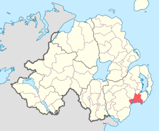
Lecale Lower is a barony in County Down, Northern Ireland. It lies to the east of the county with Strangford Lough to its north and the Irish Sea to its right. It is bordered by five other baronies: Lecale Upper to the south; Ards Upper to the north-east just across the mouth of Strangford Lough; Dufferin to the north; Castlereagh Upper to the north-west; and Kinelarty to the west.
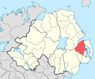
Lecale Upper is a barony in County Down, Northern Ireland. To its south lies the Irish Sea, and it is bordered by three other baronies; Lecale Lower and Kinelarty to the north; and Iveagh Upper, Lower Half to the west.
Killinchy is a civil parish in County Down, Northern Ireland. It is mainly situated in the historic barony of Dufferin, with two smaller portions in the baronies of Castlereagh Upper and Castlereagh Lower.

Kinelarty is a former Irish district and barony in County Down, Northern Ireland. It lies east of the centre of the county, and is bordered by five other baronies: Iveagh Upper, Lower Half to the west; Lecale Upper to the south and south-east; Lecale Lower to the east; Castlereagh Upper to the north; and Iveagh Lower, Upper Half to the north-west.

Iveagh Upper, Lower Half is the name of a barony in County Down, Northern Ireland. It was created by 1851 with the division of the barony of Iveagh Upper into two. It lies in the centre of the county, and is bordered by six other baronies: Iveagh Upper, Upper Half and Lordship of Newry to the west; Mourne to the south; Kinelarty and Lecale Upper to the east; and Iveagh Lower, Upper Half to the north.

Iveagh Lower, Upper Half is a barony in County Down, Northern Ireland. It was created by 1851 with the division of the barony of Iveagh Lower into two. It is bordered by five other baronies: Iveagh Upper, Lower Half to the south; Iveagh Upper, Upper Half to the south-west; Iveagh Lower, Lower Half to the west and north; Castlereagh Upper to the north-east; and Kinelarty to the west.

Iveagh Lower, Lower Half is the name of a barony in County Down, Northern Ireland. It was created by 1851 with the division of the barony of Iveagh Lower into two. It is bordered by six other baronies: Massereene Upper to the north; Castlereagh Upper to the east; Iveagh Lower, Upper Half and Iveagh Upper, Upper Half to the south; Oneilland East and Orior Lower to the west.

Iveagh is the name of several historical territorial divisions in what is now County Down, Northern Ireland. Originally it was a Gaelic Irish territory, ruled by the Uí Echach Cobo and part of the overkingdom of Ulaid. From the 12th century the Magennises were chiefs of Iveagh. They were based at Rathfriland and were inaugurated at Knock Iveagh. Following the Nine Years' War, the rulers of Iveagh submitted to the English Crown and the territory was divided between them. Iveagh became a barony, which was later split into Iveagh Lower and Iveagh Upper. The territory of Iveagh was also the basis of the Roman Catholic Diocese of Dromore.
Castlereagh is a townland and former hamlet in the civil parish of Knockbreda, barony of Castlereagh Lower, in County Down, Northern Ireland. It is southeast of Belfast and now at the fringe of the city's suburbs. The townland has an area of 415 acres (168 ha).

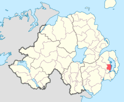
Castlereagh Lower is a historic barony in County Down, Northern Ireland. It was created by 1841 with the division of Castlereagh into two. The barony roughly matches the former Gaelic territory of Uí Blathmaic, anglicized Blathewic. It is bordered by three other baronies: Ards Lower to the east; Dufferin to the south; and Castlereagh Upper to the west and south-west. Castlereagh Lower is also bounded by Belfast Lough to the north and Strangford Lough to the south-east.

Castlereagh Upper is a historic barony in County Down, Northern Ireland. It was created by 1841 with the division of Castlereagh into two. It is bordered by eight other baronies: Castlereagh Lower and Dufferin to the east; Lecale Lower and Kinelarty to the south; Iveagh Lower, Lower Half, Iveagh Lower, Upper Half, and Massereene Upper to the west; and Belfast Upper to the north.
Castlereagh is the name of a former barony in County Down, present-day Northern Ireland. It spanned the north-eastern area of the county bordering the baronies of: Ards to the east; Belfast to the north; Iveagh to the west south; and Dufferin, Kinelarty, and Lecale to the south. By 1841 the barony was divided into Castlereagh Lower and Castlereagh Upper.