County Londonderry, also known as County Derry, is one of the six counties of Northern Ireland, one of the thirty-two counties of Ireland and one of the nine counties of Ulster. Before the partition of Ireland, it was one of the counties of the Kingdom of Ireland from 1613 onward and then of the United Kingdom after the Acts of Union 1800. Adjoining the north-west shore of Lough Neagh, the county covers an area of 2,118 km2 (818 sq mi) and today has a population of about 252,231.

John Butler Yeats was an Irish artist and the father of W. B. Yeats, Lily Yeats, Elizabeth Corbett "Lolly" Yeats and Jack Butler Yeats. The National Gallery of Ireland holds a number of his portraits in oil and works on paper, including one of his portraits of his son William, painted in 1900. His portrait of John O'Leary (1904) is considered his masterpiece.

Portadown is a town in County Armagh, Northern Ireland. The town sits on the River Bann in the north of the county, about 24 mi (39 km) southwest of Belfast. It is in the Armagh City, Banbridge and Craigavon Borough Council area and had a population of about 22,000 at the 2011 Census. For some purposes, Portadown is treated as part of the "Craigavon Urban Area", alongside Craigavon and Lurgan.
Upper Bann is a parliamentary constituency in Northern Ireland, which is represented in the United Kingdom House of Commons. The current MP is Carla Lockhart of the DUP.

Newtownabbey is a large settlement north of Belfast city centre in County Antrim, Northern Ireland. It is separated from the rest of the city by Cavehill and Fortwilliam golf course, but it still forms part of the Belfast metropolitan area. It surrounds Carnmoney Hill, and was formed from the merging of several small villages including Whiteabbey, Glengormley and Carnmoney. At the 2021 census, Metropolitan Newtownabbey Settlement had a population of 67,599, making it the third largest settlement in Northern Ireland and seventh on the Island of Ireland. It is part of Antrim and Newtownabbey Borough Council.

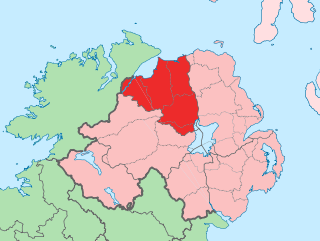
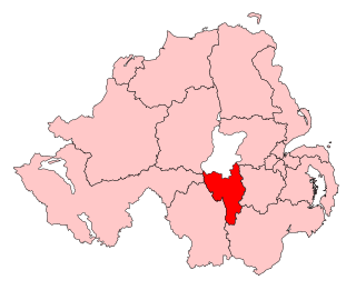
Banbridge was a local government district in Northern Ireland. The district was one of 26 council areas formed on 1 October 1973, following the implementation of the Local Government Act 1972. The headquarters of the council were in the town of Banbridge. In April 2015, most of the Banbridge district was included in the merged Armagh, Banbridge and Craigavon district. Some smaller areas in the east of the district became merged with the Newry, Mourne and Down District

Dromore is a small market town and civil parish in County Down, Northern Ireland. It lies within the local government district of Armagh City, Banbridge and Craigavon. It is 19 miles (31 km) southwest of Belfast, on the A1 Belfast–Dublin road. The 2011 Census recorded a population of 6,395.

Lawrencetown or Laurencetown (Irish: Baile Mór Shíol Anmchadha or simply Baile Mór), historically called Oghilmore and later Ballymore, is a village in County Galway, Ireland. Located on the R355 regional road nine miles south of Ballinasloe, it lies in the barony of Longford, the civil parish of Clonfert, the Catholic parish of Lawrencetown and Kiltormer, and the townland (earlier) of Lissreaghaun and (later) of Laurencetown or Ballymore; it was historically in the poor law union of Ballinasloe.

Gilford is a village in County Down, Northern Ireland. The village sits on the River Bann between the towns of Banbridge, Tandragee and Portadown. It covers the townlands of Loughans, Ballymacanallen and Drumaran. It had a population of 1,933 people in the 2011 Census. Gilford is within the Armagh, Banbridge and Craigavon district.
Richhill is a large village and townland in County Armagh, Northern Ireland. It lies between Armagh and Portadown. It had a population of 2,738 people in the 2021 Census.
Katesbridge is a small hamlet in County Down, Northern Ireland. It is within the townland of Shannaghan, just off the main route from Castlewellan to Banbridge, and 4.3 miles (7 km) north of Rathfriland. The River Bann flows by the hamlet. In the 2001 Census it had a population of 135 people. It lies within the Banbridge District.

Lenaderg is a small village and townland of 335 acres (136 ha) in County Down, Northern Ireland. It sits on the banks of the River Bann, about two miles from Banbridge and a half mile from the village of Lawrencetown. It is situated in the civil parish of Tullylish and the historic barony of Iveagh Lower, Upper Half. In the 2001 Census it had a population of 261 people. Lenaderg is within the District of Banbridge.

Tullylish is a small village, townland and civil parish in County Down, Northern Ireland. It sits on the River Bann, along the main road between the towns of Banbridge and Portadown. In the 2001 Census it had a population of 105 people. It lies within the civil parish of Tullylish and Banbridge District.
Corbet is a small village and townland in County Down, Northern Ireland, 5 km east of Banbridge. It is situated in the civil parish of Magherally and the historic barony of Iveagh Lower, Lower Half. It lies within the Banbridge District. It had a population of 107 people in the 2011 Census.

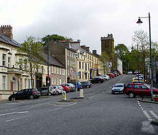
Banbridge is a town in County Down, Northern Ireland. It lies on the River Bann and the A1 road and is named after a bridge built over the River Bann in 1712. It is situated in the civil parish of Seapatrick and the historic barony of Iveagh Upper, Upper Half. The town began as a coaching stop on the road from Belfast to Dublin and thrived from Irish linen manufacturing. The town was home to the headquarters of the former Banbridge District Council. Following a reform of local government in Northern Ireland in 2015, Banbridge became part of Armagh City, Banbridge and Craigavon Borough Council. It had a population of 17,400 in the 2021 Census.

Poyntzpass is a small village on the border between southern County Armagh and County Down in Northern Ireland. It is situated in the civil parish of Ballymore and the historic barony of Orior Lower within the Armagh City, Banbridge and Craigavon area. It had a population of 552 people in the 2011 census. It was a part of the South Armagh constituency and is now part of the Newry and Armagh constituency.

Banbridge railway station was on the Banbridge, Lisburn and Belfast Railway which ran from Knockmore Junction to Banbridge in Northern Ireland.
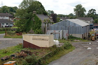
Laurencetown railway station was on the Banbridge Junction Railway which ran from Scarva to Banbridge in Northern Ireland.
Banbridge railway station was on the Banbridge Junction Railway which ran from Scarva to Banbridge in Northern Ireland.


