Greencastle, County Down

Last updated

Greencastle Greencastle County Down.jpg
Greencastle

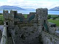
Greencastle is a castle in County Down, Northern Ireland. While it dates mainly from the 13th century, it had substantial 15th- and 16th-century alterations. It was originally surrounded by outer rectangular walls with four corner towers (ruins of some remain). It is likely to have been built by Hugh de Lacy, along with Carlingford Castle on the opposite side of Carlingford Lough, to guard the narrow entry channel to the Lough, and the ferry crossing between the two.

Contents

The motte from the earlier Norman, wooden, Motte and Bailey Castle (possibly built by John de Courcey) is still on the seaward side nearer the point. According to one legend John de Courcy was married at Greencastle Castle, but this may have been at the original motte & bailey castle. According to the information boards at the site it was held for the English Crown by Richard de Burgh, Earl of Ulster, from 1264 to 1333. [1] It was attacked and taken by Edward Bruce, the brother of Robert, in 1316. This was in spite of one of Richard de Burgh's daughters having married Robert the Bruce himself. [2] It was attacked at least twice by the Irish in the later 14th century but still maintained as an English garrison in the 1590s. In the 16th century it was held by the Earl of Kildare and then Nicholas Bagenal of Newry. It fell into disuse after a bombardment by Cromwellian soldiers, to stop it being used by rebel forces.[ citation needed ]

The site is also surrounded in close proximity by other medieval sites/monuments: e.g., the motte fortification predating the stone castle (Northern Ireland Sites and Monuments No. DOW 057:001), late-Medieval stone church (DOW 057:002) and two burial pits (DOW 057:017) that were excavated in 2003; one contained a female aged 25–35 and the second a child (one presumes related) of less than four years old at death (1 and a half to 3 and a half years old). A calibrated date range of AD1270-1380 was indicated; likely contemporary with the construction of Greencastle in the mid-13th century. [3]

The castle underwent archaeological excavations from 1966 - 1970 [4] which also identified layers of occupation deposits that pre-dated the castle on the site.

The castle is a state-care historic monument in the townland of Greencastle, in the Newry and Mourne District Council area, at grid ref: J2473 1184. [5]

Related Research Articles

<span class="mw-page-title-main">County Armagh</span> County in Northern Ireland

County Armagh is one of the six counties of Northern Ireland and one of the traditional thirty-two counties of Ireland. Adjoined to the southern shore of Lough Neagh, the county covers an area of 1,327 km2 (512 sq mi) and has a population of 194,394 as of the 2021 census. County Armagh is known as the "Orchard County" because of its many apple orchards. The county is part of the historic province of Ulster.

<span class="mw-page-title-main">County Down</span> County in Northern Ireland

County Down is one of the six counties of Northern Ireland, one of the nine counties of Ulster and one of the traditional thirty-two counties of Ireland. It covers an area of 961 sq mi (2,490 km2) and has a population of 552,261. It borders County Antrim to the north, the Irish Sea to the east, County Armagh to the west, and County Louth across Carlingford Lough to the southwest.

<span class="mw-page-title-main">Warrenpoint</span> Town in Northern Ireland

Warrenpoint is a small port town and civil parish in County Down, Northern Ireland. It sits at the head of Carlingford Lough, south of Newry, and is separated from the Republic of Ireland by a narrow strait. The town is beside the village of Rostrevor and is overlooked by the Mournes and Cooley Mountains. Warrenpoint sprang up within the townland of Ringmackilroy, and is locally nicknamed "The Point", which also represents the town's full name in Irish, An Pointe".

<span class="mw-page-title-main">Rostrevor</span> Human settlement in Northern Ireland

Rostrevor is a village and townland in County Down, Northern Ireland. It lies at the foot of Slieve Martin on the coast of Carlingford Lough, near Warrenpoint. The Kilbroney River flows through the village and Rostrevor Forest is nearby. It is within Newry, Mourne and Down District.

<span class="mw-page-title-main">Cranfield Point</span>

Cranfield Point is the southernmost point of Northern Ireland. It is located at the mouth of Carlingford Lough in the townland of Cranfield, County Down.

<span class="mw-page-title-main">Narrow Water Castle</span> 16th-century tower house in Northern Ireland

Narrow Water Castle is a 16th-century tower house and bawn near Warrenpoint in Northern Ireland. It is beside the A2 road and on the County Down bank of the Clanrye (Newry) River, which enters Carlingford Lough a mile to the south. It is a historic monument in state care in the townland of Narrow Water, in Newry and Mourne District Council district, at grid ref: J1256 1939.

<span class="mw-page-title-main">Carlingford Lough</span> Glacial fjord or sea inlet in Ireland

Carlingford Lough is a glacial fjord or sea inlet in northeastern Ireland, forming part of the border between Northern Ireland to the north and the Republic of Ireland to the south. On its northern shore is County Down, the Mourne Mountains, and the town of Warrenpoint; on its southern shore is County Louth, the Cooley Mountains and the village of Carlingford. The Newry River flows into the loch from the northwest.

<span class="mw-page-title-main">Greenore</span> Port village in County Louth, Ireland

Greenore is a village, townland and deep water port on Carlingford Lough in County Louth, Ireland.

<span class="mw-page-title-main">Carlingford, County Louth</span> Town on the Cooley Peninsula, County Louth, Ireland

Carlingford is a coastal town and civil parish in northern County Louth, Ireland. For the purposes of local government, the town is part of the Dundalk Municipal District. It is situated on the southern shore of Carlingford Lough with Slieve Foy mountain as a backdrop, sometimes known as Carlingford Mountain. It is the main town on the Cooley Peninsula. Located on the R176/R173 roads between Greenore and Omeath village, Carlingford is approximately 27 km (17 mi) north east from Dundalk, 90 km (56 mi) north of Dublin and 11 km (7 mi) south of the border with Northern Ireland. Carlingford won the Irish Tidy Towns Competition in 1988.

<span class="mw-page-title-main">Newry Canal</span> Canal in Northern Ireland, United Kingdom.

The Newry Canal is an abandoned canal in Northern Ireland. Opened in 1742, it was built to link the Tyrone coalfields to the Irish Sea. The navigable route ran from Lough Neagh via the Upper Bann river to Portadown, then approximately 20 miles from Portadown via the canal proper to Newry, terminating in the Albert Basin.

<span class="mw-page-title-main">Ring of Gullion</span> Geological formation and area

The Ring of Gullion is a geological formation and area, officially designated as an Area of Outstanding Natural Beauty, (AONB) located in County Armagh, Northern Ireland. The area centres on Slieve Gullion, the highest peak in County Armagh, measures roughly 42 by 18 kilometres and comprises some 150 km2 defined topographically by the hills of an ancient ring dyke. Parts of the area have also been officially listed as Areas of Special Scientific Interest.

<span class="mw-page-title-main">Newry River</span> River in Northern Ireland

Newry River and River Clanrye are names for one of the rivers of Ireland. The river passes through the city of Newry and empties into Carlingford Lough near Warrenpoint.

<span class="mw-page-title-main">Dundrum Castle</span> Ruined castle at Dundrum, County Down, Northern Ireland

Dundrum Castle, a ruin standing over the town of Dundrum, County Down, Northern Ireland, must not to be confused with Dundrum Castle in Dundrum, County Dublin. It was constructed by John de Courcy, sometime near the beginning of the 13th century, following his invasion of Ulster. The castle, built to control access into Lecale from the west and south, stands on the top of a rocky hill commanding fine views south over Dundrum Bay and the Mourne Mountains, the lands west towards Slieve Croob and the plains of Lecale to the east. The Castle is a State Care Historic Monument in the townland of Dundrum, in Newry, Mourne and Down District Council area, at grid ref: J4047 3700.

<span class="mw-page-title-main">Dunluce Castle</span> Medieval castle on coast of Northern Ireland

Dunluce Castle is a now-ruined medieval castle in Northern Ireland, the seat of Clan MacDonnell. It is located on the edge of a basalt outcropping in County Antrim, and is accessible via a bridge connecting it to the mainland. The castle is surrounded by extremely steep drops on either side, which may have been an important factor to the early Christians and Vikings who were drawn to this place where an early Irish fort once stood.

<span class="mw-page-title-main">Jordan's Castle</span>

Jordan's Castle is a castle situated in Ardglass, County Down, Northern Ireland. The tower house known as Jordan's Castle is a State Care Historic Monument sited in the townland of Ardglass, in the Newry, Mourne and Down District Council area, at grid ref: J5601 3713. It stands close to the junction of Kildare and Quay Streets in Ardglass and commands the harbour.

<span class="mw-page-title-main">Killowen</span>

Killowen, alternatively spelt Cill Abhainn is a small village in County Down, Northern Ireland. It is near Rostrevor and on the shore of Carlingford Lough. In the 2001 Census it had a population of 159 people. It lies within the Newry and Mourne District Council area.

<span class="mw-page-title-main">Coney Island, Lough Neagh</span> Island in Lough Neagh, Northern Ireland

Coney Island is an island in Lough Neagh, Northern Ireland. It is about 1 km offshore from Maghery in County Armagh, is thickly wooded and of nearly 9 acres (36,000 m2) in area. It lies between the mouths of the River Blackwater and the River Bann in the south-west corner of Lough Neagh. Boat trips to the island are available at weekends from Maghery Country Park or Kinnego Marina. The island is owned by the National Trust and managed on their behalf by Armagh City, Banbridge and Craigavon Borough Council. Coney Island Flat is a rocky outcrop adjacent to the island. Although Samuel Lewis called Coney Island the only island in County Armagh, Armagh's section of Lough Neagh also includes Croaghan Island, as well as the marginal cases of Padian and Derrywarragh Island.

<span class="mw-page-title-main">Holywood Priory</span>

A monastery was founded by St Laiseran before 640 on the site of the present ruins of the medieval Old Priory at the junction of High Street, Victoria Road and the Old Bangor Road in Holywood, County Down. The present ruins are late 12th / early 13th century Anglo-Norman Augustinian Abbey built by Thomas Whyte and much of these ruins remain as the fabric of the structure. The church consists of a nave & chancel without structural division, 22.5m x 6m internally, with a West tower. The original building is late 12th / early 13th century & entered on South. In the 15th century, the West end was rebuilt with a new entrance & the East window replaced. The upper levels of the tower were added in 18th century. Some of the masonry is 'Cultra Stone' ashlar and red sandstone. The Cultra Stone is also used for masonry dressings at Ardkeen and Ballywalter churches as well as other churches in the wider Ards area.

<span class="mw-page-title-main">Ballykeel Dolmen</span> Neolithic tripod portal tomb, Northern Ireland

Ballykeel Dolmen is a neolithic tripod portal tomb and a State Care Historic Monument at the foot of the western flank of Slieve Gullion, above a tributary of the Forkhill river, in the Newry, Mourne and Down District Council area, at grid ref: H9950 2132.

<span class="mw-page-title-main">Northburgh Castle</span> Ruined castle in County Donegal, Ireland

Northburgh Castle, also known as Green Castle or Greencastle Castle, is a ruined late 13th / early 14th-century castle in Greencastle, a village and fishing port in the north of Inishowen, County Donegal, on the north coast of Ireland. It was completed in 1305 by Richard Óg de Burgh, 2nd Earl of Ulster. Northburgh Castle was sited to control Lough Foyle, and to act as an enabler to de Burgh's plans for expansion. The rock outcrop/platform on which the castle is built was not big enough to incorporate the plans, so the gatehouse is below the main castle extents and has its first floor at the level of the main courtyard: the gate passage leads only to a small lower courtyard from which steps lead up to the main one. It was captured by Edward Bruce in 1316 who held the castle for two years until his death in 1318, after which it was recaptured by Richard. Walter Liath de Burgh was imprisoned in the castle in 1331 by his cousin William Donn de Burgh, 3rd Earl of Ulster, and died of starvation in February 1332. Anecdotally, that act is commemorated in the Derry City coat of arms as a skeleton. William's sister was found dead beneath the battlements. After William's death, the castle became a stronghold of the O'Doherty family.

References

  1. Reeves-Smyth, Terence. Irish Castles (PDF). NISMR: Appletree Guide. pp. 33–35.
  2. Dept of the Environment (NI) (1984). Historic Monuments of Northern Ireland (PDF). Northern Ireland: HMSO. p. 101. ISBN   0337081808.
  3. NISMR. "Two 13th to 14th century pit burials (partially in situ)". Northern Ireland Sites and Monuments Record.
  4. Gaskell-Brown, Cynthia (1979). "Excavations at Greencastle, Co. Down" (PDF). Ulster Journal of Archaeology. 43: 51–65.
  5. "Greencastle" (PDF). Environment and Heritage Service NI - State Care Historic Monuments. Archived from the original (PDF) on 22 July 2012. Retrieved 2 May 2015.

Images

54°02′26″N6°06′15″W / 54.04053°N 6.1043°W / 54.04053; -6.1043