Lordship of Newry is a historic barony in County Down, Northern Ireland. [1]
Contents


Lordship of Newry is a historic barony in County Down, Northern Ireland. [1]
Below is a list of settlements in Lordship of Newry: [1]
Below is a list of civil parishes in Lordship of Newry: [1]

County Down is one of the six counties of Northern Ireland, one of the nine counties of Ulster and one of the traditional thirty-two counties of Ireland. It covers an area of 961 sq mi (2,490 km2) and has a population of 552,261. It borders County Antrim to the north, the Irish Sea to the east, County Armagh to the west, and County Louth across Carlingford Lough to the southwest.

South Down is a parliamentary constituency in the United Kingdom House of Commons. The current MP is Chris Hazzard of Sinn Féin.
South Armagh was a UK Parliament constituency in Ireland which returned one Member of Parliament from 1885 to 1922, using the first past the post electoral system.
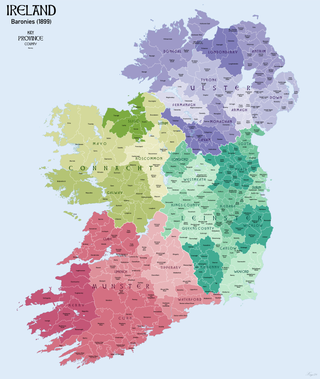
In Ireland, a barony is a historical subdivision of a county, analogous to the hundreds into which the counties of England were divided. Baronies were created during the Tudor reconquest of Ireland, replacing the earlier cantreds formed after the original Norman invasion. Some early baronies were later subdivided into half baronies with the same standing as full baronies.
A barony is an administrative division of a county in Scotland, Ireland, outlying parts of England and historically France and Sardinia. As a barony is associated to a Baron and a county to a Count or Earl, it has a lower rank and importance than a county.

A Lord in the Baronage of Scotland is an ancient title of nobility, held in baroneum, which Latin term means that its holder, who is a lord, is also always a baron. The holder may or may not be a Lord of Regality, which meant that the holder was appointed by the Crown and had the power of "pit and gallows", meaning the power to authorise the death sentence.

The Diocese of Dromore is a Latin Church diocese of the Catholic Church in Northern Ireland. It is one of eight suffragan dioceses which are subject to the Metropolitan Archdiocese of Armagh.
The Bishop of Dromore is an episcopal title which takes its name after the original monastery of Dromore in County Down, Northern Ireland. In the Roman Catholic Church the title still continues as a separate bishopric, but in the Church of Ireland it has been united with other bishoprics.

Antrim Upper is a barony in County Antrim, Northern Ireland. It is bordered by six other baronies: Antrim Lower to the north; Toome Upper to the west; Massereene Lower to the south-west; Belfast Upper to the south; Belfast Lower to the south-east; and Glenarm Upper to the east.

Belfast Upper is a barony in County Antrim, Northern Ireland. To its east lies the barony of Belfast and Belfast Lough, and it is bordered by five other baronies: Belfast Lower to the north-east; Antrim Upper to the north-west; Massereene Lower to the west; Massereene Upper to the south-west; and Castlereagh Upper to the south. The Forth River flows through both Belfast Upper and Lower. The most prominent hills in the barony are Black Hill and Lyle's Hill.

Toome Upper is a barony in County Antrim, Northern Ireland. To its south lies Lough Neagh, and it is bordered by five other baronies: Toome Lower to the north; Antrim Lower to the north-east; Antrim Upper to the east; Massereene Lower to the south-east; and Loughinsholin to the south-east. Toome Upper also formed part of the medieval territories known as the Route and Clandeboye.

Oneilland West is a barony in County Armagh, Northern Ireland. It is also called Clancann, after the Mac Cana clan. It lies in the north of the county on the south-western shore of Lough Neagh and the border of County Tyrone. Oneilland West is bordered by five other baronies: Armagh to the west; Dungannon Middle to the north-west; Oneilland East to the north-east; Orior Lower to the south-east; and Kinelarty to the south.

Orior Upper is a barony in County Armagh, Northern Ireland. It lies in the south-east of the county and borders the Republic of Ireland with its southern boundary. It is bordered by five other baronies in Northern Ireland: Fews Upper and an enclave of Fews Lower to the west; Orior Lower to the north; Iveagh Upper, Upper Half to its west, which is divided in two by the Lordship of Newry. It also borders two baronies in the Republic of Ireland: Dundalk Lower and Dundalk Upper to the south.

Kinelarty is a former Irish district and barony in County Down, Northern Ireland. It lies east of the centre of the county, and is bordered by five other baronies: Iveagh Upper, Lower Half to the west; Lecale Upper to the south and south-east; Lecale Lower to the east; Castlereagh Upper to the north; and Iveagh Lower, Upper Half to the north-west.

Iveagh Upper, Lower Half is the name of a barony in County Down, Northern Ireland. It was created by 1851 with the division of the barony of Iveagh Upper into two. It lies in the centre of the county, and is bordered by six other baronies: Iveagh Upper, Upper Half and Lordship of Newry to the west; Mourne to the south; Kinelarty and Lecale Upper to the east; and Iveagh Lower, Upper Half to the north.

Iveagh Upper, Upper Half is the name of a barony in County Down, Northern Ireland. It was created by 1851 with the division of the barony of Iveagh Upper into two. It lies to the west and south of the county, split in half by the Lordship of Newry. It is bordered by six other baronies: Mourne to the south; Iveagh Upper, Lower Half to the east; Iveagh Lower, Lower Half and Iveagh Lower, Upper Half to the north; and Orior Lower and Orior Upper to the west.

Iveagh is the name of several historical territorial divisions in what is now County Down, Northern Ireland. Originally it was a Gaelic Irish territory, ruled by the Uí Echach Cobo and part of the overkingdom of Ulaid. From the 12th century the Magennises were chiefs of Iveagh. They were based at Rathfriland and were inaugurated at Knock Iveagh. Following the Nine Years' War, the rulers of Iveagh submitted to the English Crown and the territory was divided between them. Iveagh became a barony, which was later split into Iveagh Lower and Iveagh Upper. The territory of Iveagh was also the basis of the Roman Catholic Diocese of Dromore.
Newry is a civil parish in County Armagh and County Down, Northern Ireland. It is situated in the historic baronies of Iveagh Upper, Lower Half and Lordship of Newry in County Down and the baronies of Orior Upper and Oneilland West in County Armagh.
Ardarragh is a rural townland in County Down, Northern Ireland. It has an area of 456.31 acres (1.847 km2). It is situated in the civil parish of Newry and the historic barony of Lordship of Newry, located 5.5 miles north-east of Newry. It lies within the Newry, Mourne and Down District Council.
