Lake Luzerne-Hadley, New York

Last updated
Lake Luzerne-Hadley
USA New York location map.svg
Red pog.svg
Lake Luzerne-Hadley
Usa edcp location map.svg
Red pog.svg
Lake Luzerne-Hadley
Coordinates: 43°18′57″N073°50′10″W / 43.31583°N 73.83611°W / 43.31583; -73.83611 Coordinates: 43°18′57″N073°50′10″W / 43.31583°N 73.83611°W / 43.31583; -73.83611
Country United States
State New York
Counties Saratoga, Warren
Area
  Total4.2 sq mi (11.0 km2)
  Land3.8 sq mi (9.7 km2)
  Water0.5 sq mi (1.2 km2)
Population
 (2000)
  Total2,240
  Density595.2/sq mi (229.8/km2)
Time zone UTC-5 (Eastern (EST))
  Summer (DST) UTC-4 (EDT)
FIPS code36-40667

Lake Luzerne-Hadley was a census-designated place (CDP) in Saratoga and Warren counties in the U.S. state of New York. The portion in Warren County is part of the Glens Falls Metropolitan Statistical Area. [1] The CDP consisted of the centers of population in the towns of Hadley (Saratoga County) and Lake Luzerne (Warren County).

Contents

The population was 2,240 at the 2000 census. [2] For the 2010 census, the area was redelineated as two separate CDPs, Lake Luzerne (pop. 1,227) and Hadley (pop. 1,009). The CDPs are located at the confluence of the Sacandaga and Hudson rivers.

Geography

According to the United States Census Bureau, the CDP had a total area of 4.2 square miles (11.0 km2), of which 3.8 square miles (9.7 km2) was land and 0.5 square miles (1.2 km2), or 11.11%, was water.

Demographics

As of the census [2] of 2000, there were 2,240 people, 882 households, and 606 families residing in the CDP. The population density was 595.2 per square mile (230.0/km2). There were 1,355 housing units at an average density of 360.1/sq mi (139.1/km2). The racial makeup of the CDP was 98.66% White, 0.36% African American, 0.04% Native American, 0.09% Asian, 0.04% from other races, and 0.80% from two or more races. Hispanic or Latino of any race were 0.58% of the population.

There were 882 households, out of which 33.7% had children under the age of 18 living with them, 53.3% were married couples living together, 11.3% had a female householder with no husband present, and 31.2% were non-families. 24.4% of all households were made up of individuals, and 10.7% had someone living alone who was 65 years of age or older. The average household size was 2.52 and the average family size was 2.99.

In the CDP, the population was spread out, with 26.1% under the age of 18, 7.1% from 18 to 24, 29.2% from 25 to 44, 23.1% from 45 to 64, and 14.6% who were 65 years of age or older. The median age was 38 years. For every 100 females, there were 93.4 males. For every 100 females age 18 and over, there were 90.8 males.

The median income for a household in the CDP was $34,922, and the median income for a family was $38,153. Males had a median income of $31,875 versus $19,444 for females. The per capita income for the CDP was $15,979. About 9.2% of families and 11.9% of the population were below the poverty line, including 20.1% of those under age 18 and 4.7% of those age 65 or over.

Related Research Articles

Silver Lake, Florida Census-designated place in Florida

Silver Lake is a census-designated place (CDP) in Lake County, Florida, United States. The population was 1,879 at the 2010 census. It is part of the Orlando–Kissimmee Metropolitan Statistical Area.

Gages Lake, Illinois Census-designated place in Illinois, United States

Gages Lake is a census-designated place (CDP) in Warren Township, Lake County, Illinois, United States. The population was 10,198 at the 2010 census.

Grandwood Park, Illinois census designated place

Grandwood Park is a census-designated place (CDP) in Warren Township, Lake County, Illinois, United States. The population was 5,202 at the 2010 census.

Green Valley, Maryland Former census-designated place in Maryland

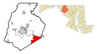
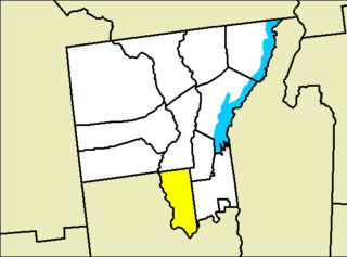
Green Valley is an unincorporated area and former census-designated place (CDP) in southern Frederick County, Maryland, United States. The population was 12,262 at the 2000 census. The area was not listed as part of any CDP at the 2010 census.

Woodstock Township, Michigan Civil township in Michigan, United States

Woodstock Township is a civil township of Lenawee County, Michigan, United States. As of the 2000 census, the township population was 3,468.

Redby, Minnesota Census-designated place in Minnesota, US

Redby is a census-designated place (CDP) within the Lower Red Lake unorganized territory in Beltrami County, Minnesota, United States. The population was 1,334 at the 2010 census.

Day, New York Town in New York, United States

Day is a town in Saratoga County, New York, United States.

Hadley, New York Town in New York, United States

Hadley is a town in Saratoga County, New York, United States. The population was 1,971 at the 2000 census. The town was named after Hadley, Massachusetts.

Lake Luzerne, New York Town in New York, United States

Lake Luzerne, formerly the Town of Fairfield and then Luzerne, is a town in southern Warren County, New York, United States. The town is located within the Adirondack Park. The town is part of the Glens Falls Metropolitan Statistical Area. Lake Luzerne is west of the city of Glens Falls. The town population was 3,347 at the 2010 census.

Silver Lake, North Carolina CDP in North Carolina, United States

Silver Lake is a census-designated place in New Hanover County, North Carolina, United States. The population was 5,598 at the 2010 census, down from 5,788 in 2000. It is part of the Wilmington Metropolitan Statistical Area.

Fairfield Beach, Ohio Census-designated place in Ohio, United States

Fairfield Beach is an unincorporated community and census-designated place (CDP) in Fairfield County, Ohio, United States. The population was 1,292 at the 2010 census.

Tresckow, Pennsylvania Census-designated place in Pennsylvania, United States

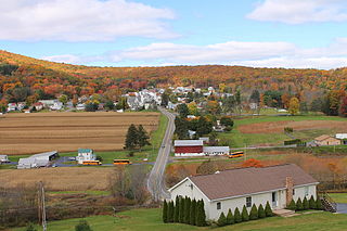
Tresckow, formerly known as Dutchtown, is an unincorporated community and census-designated place (CDP) in Carbon County, Pennsylvania, United States west of Junedale and Beaver Meadows, which share the same road network, Quakake Creek valley and roots in the Anthracite coal mining and transportation industries. The population was 880 at the 2010 census.

Canadohta Lake, Pennsylvania Census-designated place in Pennsylvania, United States

Canadohta Lake is a census-designated place (CDP) in Crawford County, Pennsylvania, United States. The population was 516 at the 2010 census.

Hiller, Pennsylvania Census-designated place in Pennsylvania, United States

Hiller is an unincorporated community and census-designated place in Fayette County, Pennsylvania, United States. As of the 2010 census, it had a population of 1,155, down from 1,234 at the 2000 census. It is located in Luzerne Township.

East Berwick, Pennsylvania Census-designated place in Pennsylvania, United States

East Berwick is a census-designated place (CDP) in Salem Township, Luzerne County, Pennsylvania, United States. The population was 2,007 at the 2010 census.

Nuremberg, Pennsylvania Census-designated place in Pennsylvania, United States

Nuremberg is a census-designated place (CDP) in Schuylkill and Luzerne counties, Pennsylvania, United States. The population was 434 at the 2010 census.

Weallup Lake, Washington former CDP in Washington, United States

Weallup Lake is a former census-designated place (CDP) in Snohomish County, Washington, United States. The population was 882 at the 2000 census. The CDP was discontinued at the 2010 census.

Milton (CDP), Saratoga County, New York CDP in New York, United States

Milton is a census-designated place (CDP) in the town of Milton in Saratoga County, New York, United States. The population was 2,692 at the 2000 census.

Corinth, New York Town in New York, United States

Corinth is a town in Saratoga County, New York, United States. The population was 6,531 at the 2010 census. The town contains a village also named Corinth. The town is on the northeast border of the county, north of Saratoga Springs. The town is noted as "the snowshoe capital of the world" and is home to Palmer Falls where the Hudson River passes through.

Milton (CDP), Vermont Census-designated place in Vermont, United States

Milton is an unincorporated village within the town of Milton in Chittenden County, Vermont, United States. The village disincorporated in 2003 and became a census-designated place (CDP) in 2008. As of the 2010 census the population was 1,861, out of a population of 10,352 for the entire town.

References

  1. "Metropolitan Areas and Components, 1999, with FIPS Codes". US Census Bureau. Retrieved July 7, 2009.
  2. 1 2 "U.S. Census website". United States Census Bureau . Retrieved 2008-01-31.