
Palo Pinto County is a county located in the U.S. state of Texas. As of the 2020 census, its population was 28,409. The county seat is Palo Pinto. The county was created in 1856 and organized the following year.

Yorktown is a town on the northern border of Westchester County, New York, United States. A suburb of the New York City metropolitan area, it is approximately 38 miles (61 km) north of midtown Manhattan. The population was 36,081 at the 2010 U.S. Census.

Ardmore is the county seat of Carter County, Oklahoma, United States. According to the 2010 census, the city had a population of 24,283, with an estimated population of 24,698 in 2019. The Ardmore micropolitan statistical area had an estimated population of 48,491 in 2013. Ardmore is 90 miles (140 km) from both Oklahoma City and Dallas/Fort Worth, Texas, at the junction of Interstate 35 and U.S. Highway 70, and is generally considered the hub of the 13-county region of South Central Oklahoma, also known by state tourism pamphlets as "Chickasaw Country" and previously "Lake and Trail Country". It is also a part of the Texoma region. Ardmore is situated about 9 miles (14 km) south of the Arbuckle Mountains and is located at the eastern margin of the Healdton Basin, one of the most oil-rich regions of the United States.

Palestine is a city in and the county seat of Anderson County in Texas, United States. As of the 2010 census, the city population was 18,712. Palestine was named for Palestine, Illinois, by preacher Daniel Parker. Another source says that it was named by migrant Micham Main for the same hometown.

Missouri City is a city in the U.S. state of Texas, within the Houston–The Woodlands–Sugar Land metropolitan area. The city is mostly in Fort Bend County, with a small portion in Harris County. As of the 2010 census, the city had a population of 67,358, up from 52,913 in 2000. The population was estimated at 75,457 in 2019.

Mineral Wells is a city in Palo Pinto and Parker Counties in the U.S. state of Texas. The population was 16,788 at the 2010 census. The city is named for mineral wells in the area, which were highly popular in the early 1900s.

The Wabash River is a 503-mile-long (810 km) river that drains most of the state of Indiana in the United States. It flows from the headwaters in Ohio, near the Indiana border, then southwest across northern Indiana turning south near the Illinois border, where the southern portion forms the Indiana-Illinois border before flowing into the Ohio River.

The Trona Railway is a 30.5 mi (49.1 km) short-line railroad owned by Searles Valley Minerals. The TRC interchanges with the Union Pacific Railroad at Searles, California.
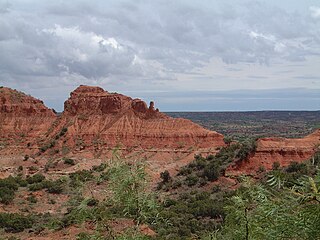
Caprock Canyons State Park and Trailway is a Texas state park located along the eastern edge of the Llano Estacado in Briscoe County, Texas, United States, approximately 100 miles (160 km) southeast of Amarillo. The state park opened in 1982 and is 15,314 acres (6,197 ha) in size, making it the third-largest state park in Texas.
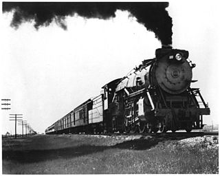
The Fort Worth and Denver Railway, nicknamed "the Denver Road", was a class I American railroad company that operated in the northern part of Texas from 1881 to 1982, and had a profound influence on the early settlement and economic development of the region.

The Saw Mill River is a 23.5-mile (37.8 km) tributary of the Hudson River in Westchester County, New York, United States. It flows from an unnamed pond north of Chappaqua to Getty Square in Yonkers, where it empties into the Hudson as that river's southernmost tributary. It is the only major stream in southern Westchester County to drain into the Hudson instead of Long Island Sound. It drains an area of 26.5 square miles (69 km2), most of it heavily developed suburbia. For 16 miles (26 km), it flows parallel to the Saw Mill River Parkway, a commuter artery, an association that has been said to give the river an "identity crisis."
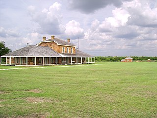
Fort Richardson was a United States Army installation located in present-day Jacksboro, Texas. Named in honor of Union General Israel B. Richardson, who died in the Battle of Antietam during the American Civil War, it was active from 1867 to 1878. Today, the site, with a few surviving buildings, is called Fort Richardson State Park, Historic Site and Lost Creek Reservoir State Trailway. It was designated a National Historic Landmark in 1963 for its role in securing the state's northern frontier in the post-Civil War era.

Niobrara State Park is a public recreation area located at the confluence of the Missouri and Niobrara rivers in the northeast corner of Nebraska. The state park occupies river bluffs to the west of the village of Niobrara and the Niobrara River. The park includes the Niobrara River Bridge, a decommissioned railroad bridge listed on the National Register of Historic Places. A variety of animals, notably white-tailed deer and wild turkeys, roam the park by day, while at night, coyotes and whip-poor-wills mingle their cries and calls. The park is managed by the Nebraska Game and Parks Commission.

Eldorado Mountain is a mountain summit on the eastern flank of the Front Range of the Rocky Mountains of North America. The 8,344-foot (2,543 m) peak is located 8.1 miles (13.1 km) south by west of downtown Boulder, Colorado, United States. The mountain is largely in Boulder County but it straddles the border and its southern flanks are located in Jefferson County. Its name was probably borrowed from the nearby community of Eldorado Springs.

The Columbia Plateau Trail is a 130-mile-long (210 km), 20-foot-wide (6.1 m) corridor in eastern Washington state maintained as part of the Washington State Park system. The trail runs along the abandoned right-of-way of the former Spokane, Portland and Seattle Railway from Cheney to the confluence of the Snake and Columbia rivers at Pasco, Washington, passing through five counties in the southeastern part of the state. The trail is mostly gravel, except for a 3.75 mile portion between the Cheney and Fish Lake trailheads. Recreational uses include hiking, mountain biking, horseback riding, in-line skating on paved portions, and wildlife viewing. The close proximity of the railroad to the paved portion makes this section of the trail a popular spot for railfanning.
Dunderberg Mountain is a 1,086-foot (331 m) mountain on the west bank of the Hudson River at the southern end of the Hudson Highlands. It lies just above Jones Point, New York, within Bear Mountain State Park and the town of Stony Point in Rockland County, New York.
Dome is a ghost town located in Yuma County, in southwestern Arizona, United States. It is located in the Dome Valley south of the Gila River. Originally Swiveler's Station, 20 miles (32 km) east of Fort Yuma on the Butterfield Overland Mail route, a post office was established here in 1858. It was first under the name of Gila City, the nearby boomtown one and a half miles (2.4 km) west of Swiveler's, but the post office closed July 14, 1863, after most of the town was swept away in the Great Flood of 1862, and then abandoned for the La Paz gold rush along the Colorado River. After the railroad passed by the site and an attempt at large scale mining of the placers began, a new post office was established as Dome in 1892 but soon closed when the attempt failed. Subsequently it opened and closed several times before finally closing in 1940.
The Quitaque Railway Tunnel or Clarity Tunnel is a 582 feet (177 m) abandoned railway tunnel in Floyd County, Texas about 10 miles (16 km) southwest of Quitaque. Construction started in 1927, and the tunnel and associated railway line were completed and opened for use in 1930. The tunnel was listed on the National Register of Historic Places in 1977, and was designated a Texas State Antiquities Landmark in 2003.

