
Limehouse is a National Rail and connected Docklands Light Railway (DLR) station in Limehouse, London, England. It is served by regional services operated by c2c to and from Fenchurch Street, and by light metro services provided by the DLR to and from Tower Gateway or Bank. On the main line, Limehouse is located 1 mile 58 chains (2.8 km) from Fenchurch Street and the following station is West Ham; on the DLR it is between Shadwell and Westferry in Travelcard Zone 2.

Westferry is a station on the Docklands Light Railway (DLR), at the junction of Limehouse Causeway and Westferry Road in Limehouse in London Docklands, England. The station is located in Travelcard Zone 2. To the west is Limehouse station, whilst to the east the DLR splits, with one branch going to Poplar station and the other to West India Quay station.

Shadwell is a Docklands Light Railway (DLR) station in Shadwell in east London, England and is between the terminals of Bank and Tower Gateway to the west and Limehouse to the east. The 1991 Bank extension joins the main DLR line just to the west of Shadwell. It is located near Shadwell railway station for London Overground services, in Travelcard Zone 2.

The Lansbury Estate is a large, historic council housing estate in Poplar and Bromley-by-Bow in the London Borough of Tower Hamlets. It is named after George Lansbury, a Poplar councillor and Labour Party MP.

Bow Road is a closed railway station in Bow, East London, that was opened in 1876 on the Bow Curve branch line by the Great Eastern Railway (GER).
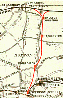
Shoreditch was a railway station on the North London Railway (NLR) in Shoreditch, London, that was in use from 1865 to 1940. It was situated on a viaduct between Haggerston and Broad Street stations. It should not be confused with Shoreditch Underground station (1869–2006) on the London Underground, situated about half a mile further south. It was also not the first main line railway station to possess the Shoreditch name; Bishopsgate (1840–1875) was originally given that name.
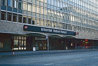
Holborn Viaduct was a railway station in the City of London, providing local and commuter services. It was located to the southeast of Holborn Viaduct, and east of Farringdon Street.

Ludgate Hill was a railway station in the City of London that was opened on 1 June 1865 by the London, Chatham and Dover Railway (LC&DR) as its City terminus. It was on Ludgate Viaduct between Queen Victoria Street and Ludgate Hill, slightly north of St. Paul's station on the site of the former Fleet Prison.
Blackwall was a railway station in Blackwall, London, that served as the eastern terminus of the Commercial Railway. It was located on the south side of the East India Docks, near the shore of the River Thames, 3 miles 43 chains (5.7 km) down-line from the western terminus at Fenchurch Street.

Poplar was a railway station in Poplar, London, that was opened in 1840 by the Commercial Railway and was situated between Millwall Junction and Blackwall, 3 miles 16 chains (5.1 km) down-line from Fenchurch Street. It was closed in 1926, at which time it was owned by the London and North Eastern Railway.
Tidal Basin railway station was a railway station near the Royal Victoria Dock, Canning Town, London, on the Eastern Counties and Thames Junction Railway. It opened in 1858, and was between Canning Town and Custom House stations. The station was damaged by bomb damage during the Blitz in 1941 but remained open until closed in 1943 as passenger numbers had fallen resulting from the area suffering from severe bombing damage and never reopened. The area was heavily redeveloped following the War, and today no trace remains; its approximate location is south east of Tarling Road, east of the present day footbridge. Royal Victoria DLR station is located approximately 300 yards east.
Millwall Junction was a railway station in Poplar, east London, on the London and Blackwall Railway (LBR).

West India Docks was a railway station in Limehouse, east London, that was opened by the Commercial Railway in 1840. It was situated between Limehouse and Millwall Junction stations, 2 miles 35 chains (3.9 km) down-line from Fenchurch Street. As the name implies, the station served the West India Docks, though it was located on the north side of the northernmost of the three docks; the LBR was later extended to a new Millwall Docks station to serve the other two docks.
Shadwell was a railway station in the parish of St. George in the East, London, that was opened by the Commercial Railway. It was situated 50 yards to the east of the current Shadwell DLR station on the Docklands Light Railway, with the former station entrance on Sutton Street. The former station was between Cannon Street Road and Stepney, and was 1 mile 5 chains (1.7 km) down-line from Fenchurch Street.
Millwall Docks was a railway station located in the Millwall area of the Isle of Dogs in east London. It was between South Dock and North Greenwich stations on the Millwall Extension Railway (MER) branch of the London and Blackwall Railway (LBR). It opened in December 1871 and was situated on the corner of Glengall Road and East Ferry Road, serving the Millwall Docks.

North Greenwich was a railway station named after the North Greenwich area of the Isle of Dogs in London. It was located on the north side of the River Thames near Island Gardens in the east of the city, and is not to be confused with the present-day North Greenwich station on the London Underground's Jubilee line, which is located on the south side of the river, one mile downstream on the Greenwich Peninsula.

National Cycle Route 1 is a route of the National Cycle Network, running from Dover to Tain. The 1,264 mi-long (2,034-kilometre) cycle-path is located in the United Kingdom.

The Dunstable Branch Lines were railway branch lines that joined the English town of Dunstable to the main lines at Leighton Buzzard and Welwyn. The two lines were under separate ownership and joined just east of the Dunstable North station.

