The following is a partial list of biking trails in Wisconsin :
The following is a partial list of biking trails in Wisconsin :
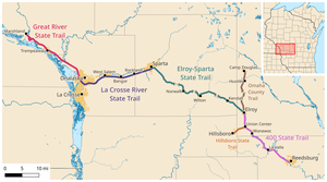

Elroy is a city in Juneau County, Wisconsin, United States, along the Baraboo River and at the east end of the Elroy-Sparta Bike Trail. The population was 1,356 at the 2020 census.

The Ice Age Trail is a National Scenic Trail stretching 1,200 miles (1,900 km) in the state of Wisconsin in the United States. The trail is administered by the National Park Service, and is constructed and maintained by private and public agencies including the Ice Age Trail Alliance, a non-profit and member-volunteer based organization with local chapters. It became an official unit of the National Park System in 2023.

Sparta is a city in and the county seat of Monroe County, Wisconsin, United States, along the La Crosse River. The population was 10,025 at the 2020 census.

Reedsburg is a city in Sauk County, Wisconsin, United States. Located along the Baraboo River, it was founded in 1868, and was named for early settler David C. Reed. The city is surrounded by the Town of Reedsburg. It is part of the Baraboo Micropolitan Statistical Area.

The Elroy-Sparta State Trail is a 32.5-mile (52.3 km) Wisconsin State rail trail between Elroy and Sparta, Wisconsin. Considered to be the first rail trail when it opened in 1967, it was designed for foot, bicycle, equestrian and light motorized traffic. Designated a multi-use trail, it offers recreational access to the routes and is open to the public. The trail is part of the larger Wisconsin bike trail system operated by the state of Wisconsin. It passes through rural scenery and three tunnels. It is one of six connecting trails in west-central Wisconsin. It was added to the Rails-to-Trails Conservancy hall of Fame in September 2008. It is one of the most popular trails in Wisconsin.

The Kettle Moraine State Forest is a state forest in southeastern Wisconsin. The chief feature of the reserve is the Kettle Moraine, a highly glaciated area. The area contains very hilly terrain and glacial landforms, such as kettles, kames and eskers. The 56,000-acre (23,000 ha) forest is divided into two large and three small units, which are spread across a hundred miles.

State Trunk Highway 71 is a 53.55-mile (86.18 km) state highway in Jackson, Monroe, and Juneau counties in the southwestern area of the US state of Wisconsin that runs in a southeast–northwest direction from the Village of Melrose to Elroy.

Lake Wissota State Park is a 1,062-acre (430 ha) Wisconsin state park near the town of Chippewa Falls. The park is situated on the northeast shore of Lake Wissota, a reservoir on the Chippewa River. Camping, boating, and fishing are the most popular activities. Park lands are covered in a mix of pine/hardwood forests and prairie. Visitors can access the Old Abe State Trail and bike or hike 17.5 miles (28.2 km) to Brunet Island State Park.

The Oak Leaf Trail is a paved 135-mile (217 km) multi-use recreational trail system which encircles Milwaukee County, Wisconsin. Clearly marked trail segments connect all of the major parks in the Milwaukee County Park System.

Wisconsin, a state in the Midwestern United States, has a vast and diverse geography famous for its landforms created by glaciers during the Wisconsin glaciation 17,000 years ago. The state can be generally divided into five geographic regions—Lake Superior Lowland, Northern Highland, Central Plain, Eastern Ridges & Lowlands, and Western Upland. The southwestern part of the state, which was not covered by glaciers during the most recent ice age, is known as the Driftless Area. The Wisconsin glaciation formed the Wisconsin Dells, Devil's Lake, and the Baraboo Range. A number of areas are protected in the state, including Devil's Lake State Park, the Apostle Islands National Lakeshore, and the Chequamegon–Nicolet National Forest.

Kohler-Andrae State Park comprises two adjacent Wisconsin state parks located in the Town of Wilson, a few miles south of the city of Sheboygan. They are managed as one unit. Terry Andrae State Park, established in 1927, and John Michael Kohler State Park, established in 1966, total 988 acres (4.00 km2). The parks contain over two miles (3 km) of beaches and sand dunes along the shore of Lake Michigan, with woods and wetlands away from the water. The Black River flows through the parks.

The Palatka-Lake Butler State Trail (PLB) corridor stretches nearly 47 miles (76 km) from the vicinity of Lake Butler, Florida to Palatka, Florida. The project is located along the former Georgia Southern and Florida Railway right-of-way and the trail is being constructed on top of the existing abandoned railroad bed through Putnam, Clay, Bradford, and Union counties.

The Glacial Drumlin State Trail is a multipurpose rail trail in the U.S. State of Wisconsin. It stretches 52 miles (84 km) from Waukesha to Cottage Grove. The trail travels through or near the Wisconsin communities of Cottage Grove, Deerfield, London, Lake Mills, Jefferson, Helenville, Sullivan, Dousman, Genesee, Wales, and Waukesha. In Lake Mills, it crosses Rock Lake on one of its many old railroad bridges. The trail was opened in 1986 and follows the old Chicago and North Western Railway (C&NW) Madison–Milwaukee mainline.

The 400 State Trail is a 22-mile (35 km) rail trail between Reedsburg and Elroy, Wisconsin. It is designed for foot, bicycle, equestrian, snowmobile traffic. It is designated as a multi-use trail, offering recreational access to the routes, and is open to the public.

The La Crosse River State Trail is a 22-mile (35 km) rail trail between Sparta and Onalaska, Wisconsin. It is designed for foot, bicycle, equestrian or light motorized traffic. It is designated as a multiuse trail, offering recreational access to the routes, and is open to the public. The trail runs parallel to the La Crosse River.

The Great River State Trail is a 24-mile (39 km) rail trail between Onalaska and Marshland, Wisconsin. It is designed for foot, bicycle, equestrian or light motorized traffic. It is designated as a multiuse trail, offering recreational access to the routes, and is open to the public.

The Hank Aaron State Trail is a 15.2-mile (24.5 km) shared-use path in Milwaukee County, Wisconsin, United States. Named after former Milwaukee Braves and Milwaukee Brewers right fielder Hank Aaron, the trail travels east-west between Lakeshore State Park in Milwaukee and Underwood Parkway in Wauwatosa via the Menomonee Valley. It is composed of rail trail, Menomonee River-following, and on-street segments. The trail sees approximately 200,000 users each year.

The Willapa Hills Trail is a 56.0-mile (90.1 km) intercounty rail trail in the U.S. state of Washington that is part of the Willapa Hills State Park. Following an east–west route alongside State Route 6, the tract links Chehalis and South Bend, traveling through or near several small towns and parks along the way. Overseen by the Washington State Park System, local cities and towns often maintain areas of the trail within their jurisdictions. The trail is built upon a decommissioned railroad track.