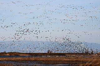
The Sacramento National Wildlife Refuge Complex is part of the United States system of National Wildlife Refuges (NWR). It is located in northern California, in the valley of the Sacramento River.

Pelican Island National Wildlife Refuge is a United States National Wildlife Refuge (NWR), and part of the Everglades Headwaters NWR complex, located just off the western coast of Orchid Island in the Indian River Lagoon east of Sebastian, Florida. The refuge consists of a 3-acre (12,000 m2) island that includes an additional 2.5 acres (10,000 m2) of surrounding water and is located off the east coast of Florida of the Indian River Lagoon. Established by an executive order of President Theodore Roosevelt on March 14, 1903, Pelican Island was the first National wildlife refuge in the United States. It was created to protect egrets and other birds from extinction through plume hunting.
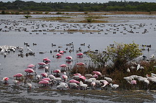
Merritt Island National Wildlife Refuge is a 140,000 acres (57,000 ha) U.S. National Wildlife Refuge (NWR) on the Atlantic coast of Florida's largest barrier island. NASA's Kennedy Space Center and visitor complex are also situated on the island and NASA can restrict access to the refuge based on its operational needs.
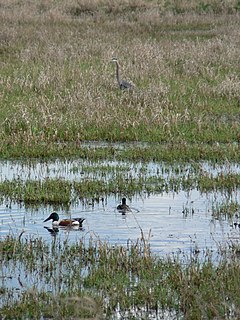
Ridgefield National Wildlife Refuge is a wildlife preserve, one of the national wildlife refuges operated by the United States Fish and Wildlife Service, located in the westernmost part of Clark County, Washington. The refuge protects more than 5,200 acres (2,100 ha) of marshes, grasslands, and woodlands. The refuge was established in 1965, in response to a need to establish vital winter habitat for wintering waterfowl with an emphasis on the dusky Canada goose whose nesting areas in Alaska were severely impacted by the violent earthquake of 1964.
The Klamath Basin National Wildlife Refuge Complex is a wildlife preserve operated by the United States Fish and Wildlife Service in the Klamath Basin of southern Oregon and northern California near Klamath Falls, Oregon. It consists of Bear Valley, Klamath Marsh and Upper Klamath National Wildlife Refuge (NWR) in southern Oregon and Lower Klamath, Tule Lake, and Clear Lake NWR in northern California.

The Hanford Reach National Monument is a national monument in the U.S. state of Washington. It was created in 2000, mostly from the former security buffer surrounding the Hanford Nuclear Reservation. The area has been untouched by development or agriculture since 1943. Because of that it is considered an involuntary park.

The Crystal River National Wildlife Refuge is part of the United States National Wildlife Refuge (NWR) System, located in Kings Bay, in the town of Crystal River, and consists of 20 islands and several small parcels of land. The 80-acre (32 ha) refuge was established in 1983, to protect the West Indian Manatee.

The Passage Key National Wildlife Refuge is part of the United States National Wildlife Refuge (NWR) System, located offshore from St. Petersburg. The 64-acre (0.26 km2) refuge was established in 1905 by President Theodore Roosevelt to preserve nesting colonies of native seabirds and wading birds. The Passage Key Wilderness Area is part of the refuge, and consists of 36.37 acres (0.1472 km2) of its total area. It was established in 1970, to protect native birds and serve as a breeding ground for them.

The Pinellas National Wildlife Refuge is part of the United States National Wildlife Refuge (NWR) System, located offshore from mainland St. Petersburg, Florida, and only accessible by boat. The 394-acre (1.59 km2) refuge was established in 1951, to act as a breeding ground for colonial bird species. Islands within the refuge include Indian, Tarpon, Mule, and Jackass Keys, and all are within the St. Petersburg city limits.

Lost Lake National Wildlife Refuge is a 960-acre (390 ha) National Wildlife Refuge (NWR) in the U.S. state of North Dakota. Lost Lake NWR is an easement refuge and is on privately owned land, but the landowners and U.S. Government work cooperatively to protect the resources. The U.S. Fish and Wildlife Service oversees Lost Lake NWR from offices at Audubon National Wildlife Refuge.
McLean National Wildlife Refuge is a 760-acre (310 ha) National Wildlife Refuge (NWR) in the U.S. state of North Dakota. A little less than half the acreage of McLean NWR is on public lands, while the rest is an easement refuge and is on privately owned land, but the landowners and U.S. Government work cooperatively to protect the resources. The U.S. Fish and Wildlife Service oversees McLean NWR from their offices at Audubon National Wildlife Refuge. Originally called Lake Susie NWR, the name of the refuge was changed to its current title in the 1990s.

Siletz Bay National Wildlife Refuge is a U.S. National Wildlife Refuge on Oregon's coast. It is one of six National Wildlife Refuges (NWRs) comprising the Oregon Coast National Wildlife Refuge Complex. The refuge consists of several discontinuous tracts north and south of the Siletz River where it enters Siletz Bay south of Lincoln City. Previously closed to public use, excluding viewing from outside the refuge boundaries and during special events, the refuge now has a boat launch offering access to non-motorized boats. Alder Island Nature Trail caters to visitors on foot, opened in 2017, and is 0.85 miles (1.37 km) round trip.

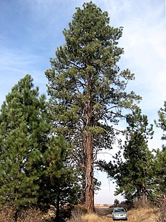
The Turnbull National Wildlife Refuge is located six miles (10 km) south of Cheney, Washington, on the eastern edge of the Columbia Basin in Spokane County in northeastern Washington. Turnbull NWR encompasses more than 18,000 acres (7,300 ha) of the Channeled Scablands. The ecosystem that predominates the refuge is unique within the National Wildlife Refuge System and has characteristics that distinguish it from natural reserves worldwide. The combination of basalt outcrops, channeled canyons, and ponderosa pine forests infused in a diverse landscape of over 130 marshes, wetlands, and lakes creates an environment of aesthetic beauty as well as high quality wildlife habitat. The refuge is named for Cyrus Turnbull who lived on the site in the 1880s.

The Blackbeard Island National Wildlife Refuge is a 5,618 acre National Wildlife Refuge located in McIntosh county in Georgia. The refuge was established to provide a nature and forest preserve for aesthetic and conservation purposes.
The Columbia Plateau Trail is a 130-mile-long (210 km), 20-foot-wide (6.1 m) corridor in eastern Washington state maintained as part of the Washington State Park system. The trail runs along the abandoned right-of-way of the former Spokane, Portland and Seattle Railway from Cheney to the confluence of the Snake and Columbia rivers at Pasco, Washington, passing through five counties in the southeastern part of the state. The trail's recreational uses include hiking, mountain biking, horseback riding, in-line skating on paved portions, and wildlife viewing.

The Rappahannock River Valley National Wildlife Refuge was established in 1996 to protect and enhance fish, wildlife, plants and their habitats for future generations. On the Rappahannock River Valley National Wildlife Refuge, birds raise their young in native habitats of field, forest and marsh. They find rest and nourishment during migration and a haven in winter. U.S. Fish & Wildlife staff manage refuge lands and waters with an emphasis on species whose populations have declined, assisting them on the road to recovery.
Bogue Chitto National Wildlife Refuge is located 60 mi (97 km) northeast of New Orleans, Louisiana, U.S., and encompasses 36,000 acres (150 km2) of Pearl River Basin swampland.
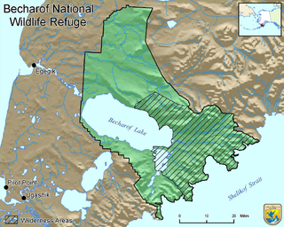
Becharof National Wildlife Refuge is a National Wildlife Refuge in the Aleutian Range of the Alaska Peninsula of southwestern Alaska. It is adjacent to Katmai National Park and Preserve. This national wildlife refuge, which covers an area of 1,200,000 acres (4,900 km2), was established in 1980 to conserve major brown bears, salmon, migratory birds, caribou, marine birds, and mammals and to comply with treaty obligations. It lies primarily in the east-central part of Lake and Peninsula Borough, but extends eastward into the mainland portion of Kodiak Island Borough. The refuge is administered from offices in King Salmon.

McNary National Wildlife Refuge is a wildlife preserve, one of the national wildlife refuges operated by the United States Fish and Wildlife Service. Extending along the east bank of the Columbia River in southeastern Washington, from the confluence of the Snake River to the mouth of the Walla Walla River, and downstream into Oregon, McNary NWR is located in rural Burbank, but very close to the rapid development of the Tri-Cities. In fact, the refuge meets the definition of an "urban refuge." Few areas in North America support waterfowl populations in the extraordinary numbers found here. Visitors enjoy spectacular concentrations of Canada geese, mallards, and other waterfowl. More than half the mallards in the Pacific Flyway overwinter at some time in this portion of the Columbia River Basin.
Wintering River National Wildlife Refuge is a National Wildlife Refuge in McHenry County, North Dakota. It is managed under J. Clark Salyer National Wildlife Refuge.


