Mount Hanover

Last updated
Mount Hanover
Mt. Hanover.jpg
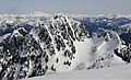
West aspect, seen from Hat Pass
Highest point
Elevation 1,748 m (5,735 ft) [1]
Prominence 228 m (748 ft) [1]
Parent peak Brunswick Mountain (1,788 m) [1]
Isolation 1.45 km (0.90 mi) [1]
Listing Mountains of British Columbia
Coordinates 49°29′57″N123°11′02″W / 49.49917°N 123.18389°W / 49.49917; -123.18389 [2]
Naming
Etymology House of Hanover
Geography
21 Squamish-Lillooet Regional District British Columbia.svg
Red triangle with thick white border.svg
Mount Hanover
Location in Squamish-Lillooet Regional District
Canada British Columbia relief location map.jpg
Red triangle with thick white border.svg
Mount Hanover
Mount Hanover (British Columbia)
Location Cypress Provincial Park [3]
British Columbia, Canada
Region Squamish-Lillooet Regional District
District New Westminster Land District
Parent range Britannia Range
North Shore Mountains
Coast Mountains
Topo map NTS 92G6 North Vancouver [2]
Climbing
First ascent 1913 by Don Munday and party
Easiest route Scrambling via South gully

Mount Hanover is a mountain summit located in British Columbia, Canada. [3]

Contents

Description

Mount Hanover is a 1,748-meter-elevation (5,735-foot) peak situated in Cypress Provincial Park, 24 kilometers (15 miles) north of Vancouver, in the Britannia Range of the North Shore Mountains, which are subsets of the Coast Mountains. [1] Hanover is the second-highest peak of the North Shore Mountains, after Brunswick Mountain. [4] Precipitation runoff from Mount Hanover drains east to the Capilano River, and west to Howe Sound via Deeks Creek. Mount Hanover is more notable for its steep rise above local terrain than for its absolute elevation. Topographic relief is significant as the summit rises 1,748 meters (5,735 feet) above Howe Sound in five kilometers (3.1 miles).

History

The first ascent of the summit was made May 23, 1913, by Don Munday, Ben Hanafin and Edward LaPage. [5] The mountain's toponym was officially adopted December 7, 1937, by the Geographical Names Board of Canada. [2] The peaks in the Britannia Range (Mts. Brunswick, Hanover, Windsor) are named for British royalty, in this case the House of Hanover.

Climate

Based on the Köppen climate classification, Mount Hanover is located in the marine west coast climate zone of western North America. [6] Most weather fronts originate in the Pacific Ocean, and travel east toward the Coast Mountains where they are forced upward by the range (Orographic lift), causing them to drop their moisture in the form of rain or snowfall. As a result, the Coast Mountains experience high precipitation, especially during the winter months in the form of snowfall. Temperatures in winter can drop below −20 °C with wind chill factors below −30 °C.

See also

Related Research Articles

<span class="mw-page-title-main">North Shore Mountains</span> Mountain range in British Columbia, Canada

The North Shore Mountains are a mountain range overlooking Vancouver in British Columbia, Canada. Their southernmost peaks are visible from most areas in Vancouver and form a distinctive backdrop for the city.

<span class="mw-page-title-main">Mount Munday</span>

Mount Munday is one of the principal summits of the Pacific Ranges of the Coast Mountains in British Columbia, Canada. It is 3,356 m (11,010 ft) in elevation and stands in the Waddington Range six kilometres southeast of Mount Waddington 4,019 m (13,186 ft), which is the highest summit in the Coast Mountains.

<span class="mw-page-title-main">Britannia Range (Canada)</span>

The Britannia Range is a small mountain range of the Coast Mountains that runs along the eastern shore of Howe Sound just north of Vancouver, British Columbia, Canada. It is a subrange of the Pacific Ranges and often considered part of the North Shore Mountains. The range is bounded by the Howe Sound to the west, the Stawamus River to the north, Loch Lomond on the upper Seymour River to the east, and Deeks Lake to the south. However, some official maps extend the range further south of these boundaries and many local sources such as hiking guidebooks will often include all of the peaks along the Howe Sound between Deeks Lake and Cypress Mountain as part of the range.

<span class="mw-page-title-main">Overlord Mountain</span> Mountain in the country of Canada

Overlord Mountain is a 2,625-metre (8,612-foot) glacier-clad peak located in the Garibaldi Ranges of the Coast Mountains, in Garibaldi Provincial Park of southwestern British Columbia, Canada. It is the highest point of the Fitzsimmons Range, which is a subset of the Garibaldi Ranges, and can be readily seen from the Whistler Blackcomb ski area. It is situated 15 km (9 mi) southeast of Whistler, and its nearest higher peak is Mount Macbeth, 3 km (2 mi) to the north-northeast. The Benvolio Glacier rests below the south aspect of the summit, the Fitzsimmons Glacier on the east aspect, and the expansive Overlord Glacier spans the northern and western aspects of the mountain. Precipitation runoff from the peak and meltwater from its glaciers drains into tributaries of the Cheakamus River. The first ascent of the mountain was made in 1923 by Phyllis Munday and Don Munday via the Benvolio Glacier. The mountain's descriptive name was recommended by the Garibaldi Park Board and officially adopted on September 2, 1930, by the Geographical Names Board of Canada.

<span class="mw-page-title-main">Mount Benvolio</span> Mountain in the country of Canada

Mount Benvolio is a 2,613-metre (8,573-foot) glacier-clad peak located in the Garibaldi Ranges of the Coast Mountains, in Garibaldi Provincial Park of southwestern British Columbia, Canada. It is the second-highest point of the Fitzsimmons Range, which is a subset of the Garibaldi Ranges. It is situated 15 km (9 mi) southeast of Whistler, and its nearest higher peak is Overlord Mountain, 0.7 km (0 mi) to the northwest. The Benvolio Glacier is set on the western slope of the peak, the Diavolo Glacier spreads out below the eastern aspect of the summit, and the Fitzsimmons Glacier descends the north slope. Precipitation runoff from the peak and meltwater from its glaciers drains into tributaries of the Cheakamus River.

<span class="mw-page-title-main">Otter Mountain</span>

Otter Mountain is a prominent 2,693-metre (8,835-foot) glaciated summit located in the Coast Mountains of British Columbia, Canada. It is situated 16 kilometers northeast of Stewart, British Columbia, and the nearest higher peak is Mount Pattullo, 25.4 km (15.8 mi) to the north. Otter ranks as the 23rd most topographically prominent summit of Canada. Topographic relief is significant as the summit rises 2,380 meters above Bitter Creek Valley in 5 kilometers. This mountain's toponym was adopted as "Mount Otter" on 24 July 1945, and officially renamed Otter Mountain on 5 November 1953 by the Geographical Names Board of Canada. Precipitation runoff from the mountain drains west into Bitter Creek which is a tributary of the Bear River, or east to Nelson Creek which is part of the Nass River drainage basin, and all ultimately finds its way to the Inside Passage.

<span class="mw-page-title-main">Cathedral Mountain (North Shore Mountains)</span> Mountain in the country of Canada

Cathedral Mountain is a mountain summit located in British Columbia, Canada.

<span class="mw-page-title-main">Mount Habrich</span> Mountain in the country of Canada

Mount Habrich is a mountain summit located in British Columbia, Canada.

<span class="mw-page-title-main">Mount Sheer</span> Mountain in the country of Canada

Mount Sheer is a mountain summit located in British Columbia, Canada.

<span class="mw-page-title-main">Mount Tinniswood</span> Mountain in the country of Canada

Mount Tinniswood is a 2,606-metre (8,550-foot) mountain summit located in British Columbia, Canada.

<span class="mw-page-title-main">Grenelle Mountain</span> Mountain summit in British Columbia, Canada

Grenelle Mountain is a 3,047-metre (9,997-foot) mountain summit located in British Columbia, Canada.

<span class="mw-page-title-main">Bravo Peak</span>

Bravo Peak is a 3,105-metre (10,187-foot) summit located in British Columbia, Canada.

<span class="mw-page-title-main">Spearman Peak</span>

Spearman Peak is a 3,365-metre (11,040-foot) summit located in British Columbia, Canada.

<span class="mw-page-title-main">Big Snow Mountain (British Columbia)</span> Mountain in the country of Canada

Big Snow Mountain is a 2,357-metre (7,733-foot) mountain summit located in British Columbia, Canada.

<span class="mw-page-title-main">Mount Carr</span> Mountain in the country of Canada

Mount Carr is a 2,590-metre (8,497-foot) mountain summit located in British Columbia, Canada.

<span class="mw-page-title-main">Isosceles Peak</span> Mountain in the country of Canada

Isosceles Peak is a 2,488-metre (8,163-foot) mountain summit located in British Columbia, Canada.

<span class="mw-page-title-main">Phyllis's Engine</span> Mountain in the country of Canada

Phyllis's Engine is a 2,517-metre (8,258-foot) granite pinnacle located in British Columbia, Canada.

<span class="mw-page-title-main">Guard Mountain</span> Mountain in the country of Canada

Guard Mountain is a 2,177-metre (7,142-foot) summit in British Columbia, Canada.

<span class="mw-page-title-main">Parapet Peak (Garibaldi Provincial Park)</span> Mountain in the country of Canada

Parapet Peak is a 2,463-metre (8,081-foot) mountain summit located in British Columbia, Canada.

<span class="mw-page-title-main">Deception Peak</span> Mountain in the country of Canada

Deception Peak is a 2,233-metre (7,326-foot) summit in British Columbia, Canada.

References

  1. 1 2 3 4 5 "Mount Hanover, British Columbia". Peakbagger.com. Retrieved 2022-11-16.
  2. 1 2 3 "Mount Hanover". Geographical Names Data Base . Natural Resources Canada . Retrieved 2022-11-16.
  3. 1 2 "Mount Hanover". BC Geographical Names . Retrieved 2022-11-16.
  4. North Vancouver Area, Peakbagger.com, Retrieved 11//16/2022
  5. Kathryn Bridge (2006), A Passion for Mountains: The Lives of Don and Phyllis Munday, Rocky Mountain Books, ISBN   9781894765695, p. 31-34
  6. Peel, M. C.; Finlayson, B. L. & McMahon, T. A. (2007). "Updated world map of the Köppen−Geiger climate classification". Hydrol. Earth Syst. Sci. 11. ISSN   1027-5606.