Potts Camp, Mississippi

Last updated

Potts Camp, Mississippi
Potts-Camp-block-ms.jpg
Potts Camp
Flag of Potts Camp, Mississippi.png
Marshall County Mississippi Incorporated and Unincorporated areas Potts Camp Highlighted.svg
Location in Marshall County and the state of Mississippi
Usa edcp location map.svg
Red pog.svg
Potts Camp, Mississippi
Location in the United States
Coordinates: 34°38′53″N89°18′17″W / 34.64806°N 89.30472°W / 34.64806; -89.30472
Country United States
State Mississippi
County Marshall
Area
[1]
  Total0.97 sq mi (2.52 km2)
  Land0.97 sq mi (2.52 km2)
  Water0.00 sq mi (0.00 km2)
Elevation
344 ft (105 m)
Population
 (2020) [2]
  Total416
  Density428.42/sq mi (165.34/km2)
Time zone UTC-6 (Central (CST))
  Summer (DST) UTC-5 (CDT)
ZIP code
38659
Area code 662
FIPS code 28-59720
GNIS feature ID0694464

Potts Camp is a town in Marshall County, Mississippi, United States. The population was 416 at the 2020 census, [2] down from 523 in 2010.

Contents

History

Potts Camp is rooted in a trading post established along the Pontotoc Trail by Colonel Erasmus Potts in the mid-19th century. The town incorporated in 1912. [3]

Geography

Potts Camp is located in southeastern Marshall County at 34°38′53″N89°18′17″W / 34.64806°N 89.30472°W / 34.64806; -89.30472 (34.647997, -89.304598). [4] It is bordered to the east by Benton County. The town is located 30 miles (48 km) northeast of Oxford along Mississippi Highway 178. Interstate 22 passes through the northern part of town, leading northwest 12 miles (19 km) to Holly Springs, the Marshall county seat, and southeast 21 miles (34 km) to New Albany.

According to the U.S. Census Bureau, Potts Camp has a total area of 1.0 square mile (2.6 km2), all land. Oaklimeter Creek, a tributary of the Tippah River, runs along the town's southwestern boundary.

Demographics

Historical population
CensusPop.Note
1900 306
1910 3122.0%
1920 3192.2%
1930 3262.2%
1940 39420.9%
1950 4329.6%
1960 429−0.7%
1970 4597.0%
1980 52514.4%
1990 483−8.0%
2000 4942.3%
2010 5235.9%
2020 416−20.5%
U.S. Decennial Census [5]

2020 census

Potts Camp Racial Composition [6]
RaceNum.Perc.
White 24358.41%
Black or African American 14935.82%
Other/Mixed 204.81%
Hispanic or Latino 40.96%

As of the 2020 United States Census, there were 416 people, 257 households, and 145 families residing in the town.

2000 census

As of the census [7] of 2000, there were 494 people, 195 households, and 135 families residing in the town. The population density was 552.5 inhabitants per square mile (213.3/km2). There were 225 housing units at an average density of 251.6 per square mile (97.1/km2). The racial makeup of the town was 66.60% White, 32.59% African American, and 0.81% from two or more races. Hispanic or Latino of any race were 0.61% of the population.

There were 195 households, out of which 36.9% had children under the age of 18 living with them, 43.6% were married couples living together, 20.0% had a female householder with no husband present, and 30.3% were non-families. 26.2% of all households were made up of individuals, and 10.8% had someone living alone who was 65 years of age or older. The average household size was 2.53 and the average family size was 3.01.

In the town, the population was spread out, with 29.4% under the age of 18, 10.5% from 18 to 24, 28.1% from 25 to 44, 20.6% from 45 to 64, and 11.3% who were 65 years of age or older. The median age was 31 years. For every 100 females, there were 85.0 males. For every 100 females age 18 and over, there were 81.8 males.

The median income for a household in the town was $23,472, and the median income for a family was $30,903. Males had a median income of $28,333 versus $21,875 for females. The per capita income for the town was $11,600. About 20.1% of families and 23.0% of the population were below the poverty line, including 27.0% of those under age 18 and 18.8% of those age 65 or over.

Education

Potts Camp is served by the Marshall County School District.

Notable people

Related Research Articles

<span class="mw-page-title-main">Union County, Mississippi</span> County in Mississippi, United States

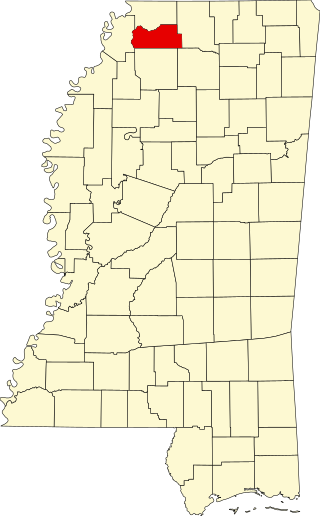
Union County is a county located in the U.S. state of Mississippi. It was formed in 1870 from Tippah and Pontotoc counties, and in 1874 a portion of Lee County was added. As of the 2020 census, the population was 27,777. Its county seat is New Albany. According to most sources, the county received its name by being a union of pieces of several large counties, like other Union counties in other states. However, other sources say that the name was meant to mark the re-union of Mississippi and the other Confederate states after the Civil War.

<span class="mw-page-title-main">Tate County, Mississippi</span> County in Mississippi, United States

Tate County is a county located in the northwestern portion of the U.S. state of Mississippi. As of the 2020 census, the population was 28,064. Its county seat is Senatobia. Organized in 1873 during the Reconstruction era, from portions of DeSoto, Marshall, and Tunica counties, the county is named for Thomas Simpson Tate, one of the first prominent American settlers of the area.

<span class="mw-page-title-main">Prentiss County, Mississippi</span> County in Mississippi, United States

Prentiss County is a county located in the U.S. state of Mississippi. As of the 2020 census, the population was 25,008. Its county seat is Booneville. The county is named for Seargent Smith Prentiss, a noted speaker and US Congressman from Natchez.

<span class="mw-page-title-main">Marshall County, Mississippi</span> County in Mississippi, United States

Marshall County is a county located on the north central border of the U.S. state of Mississippi. As of the 2020 census, the population was 33,752. Its county seat is Holly Springs. The county is named for Chief Justice of the United States John Marshall, who presided in the early nineteenth century.

<span class="mw-page-title-main">Benton County, Mississippi</span> County in Mississippi, United States

Benton County is a county located in the U.S. state of Mississippi. As of the 2020 census, the population was 7,646. Its county seat is Ashland.

<span class="mw-page-title-main">Union Grove, Alabama</span> Town in Alabama, United States

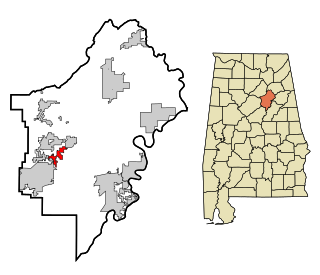
Union Grove is a town in Marshall County, Alabama, United States, and is included in the Huntsville-Decatur Combined Statistical Area. As of the 2020 census, the population of the town was 67, down from 77 at the 2010 census.

<span class="mw-page-title-main">Branchville, Alabama</span> Town in Alabama, United States

Branchville is a former town in St. Clair County, Alabama in the United States. As of the 2000 census, the population of the town was 825.

<span class="mw-page-title-main">Eagarville, Illinois</span> Village in Illinois, United States

Eagarville is a village in Macoupin County, Illinois, United States. The population was 114 at the 2020 census.

<span class="mw-page-title-main">Lacon, Illinois</span> City in Illinois, United States

Lacon is a city in, and the county seat of, Marshall County, Illinois, United States. It is part of the Peoria Metropolitan Statistical Area. The population was 1,878 at the 2020 census, down from 1,937 in 2010.

<span class="mw-page-title-main">Dakota, Minnesota</span> City in Minnesota, United States

Dakota is a city in Winona County, Minnesota, United States. The population was 295 at the 2020 census.

<span class="mw-page-title-main">Snow Lake Shores, Mississippi</span> Town in Mississippi, United States

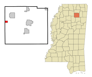
Snow Lake Shores is a town in Benton County, Mississippi, United States. The population was 319 at the 2010 census.

<span class="mw-page-title-main">French Camp, Mississippi</span> Town in Mississippi, United States

French Camp is a town in Choctaw County, Mississippi, United States. The population was 174 at the 2010 census, down from 393 in 2000.

<span class="mw-page-title-main">Pickens, Mississippi</span> Town in Mississippi, United States

Pickens is a town in Holmes County, Mississippi, United States. Per the 2020 census, the population was 920.

<span class="mw-page-title-main">Thaxton, Mississippi</span> Town in Mississippi, United States

Thaxton is a town in Pontotoc County, Mississippi, United States. The population was 643 at the 2010 census.

<span class="mw-page-title-main">Lambert, Mississippi</span> Town in Mississippi, United States

Lambert is a town in Quitman County, Mississippi. The population was 1,638 at the 2010 census.

<span class="mw-page-title-main">Falkner, Mississippi</span> Town in Mississippi, United States

Falkner is a town in Tippah County, Mississippi, United States. The population was 514 at the 2010 census. The town was named for William Clark Falkner, the great-grandfather of author William Faulkner.

<span class="mw-page-title-main">Toccopola, Mississippi</span> Town in Mississippi, United States

Toccopola is a town in Pontotoc County, Mississippi, United States. The population was 246 at the 2010 census.

<span class="mw-page-title-main">Conquest, New York</span> Town in New York, United States

Conquest is a town in Cayuga County, New York, United States. The population was 1,796 at the 2020 census. The name was chosen to mark the victory of those who wished to form the town. Conquest is on the western border of Cayuga County and is west of Syracuse.

<span class="mw-page-title-main">Springlake, Texas</span> Town in Texas, United States

Springlake is a town in Lamb County, Texas, United States. The population was 108 at the 2010 census. The community is known for its agricultural processing and its yearly Independence Day parade and celebration culminating in a fireworks display headed by the Springlake Volunteer Fire Department. This celebration usually draws several thousand participants who come together to enjoy free food, a free live band, a bake auction, and fellowship.

<span class="mw-page-title-main">Plymouth, Juneau County, Wisconsin</span> Town in Wisconsin, United States

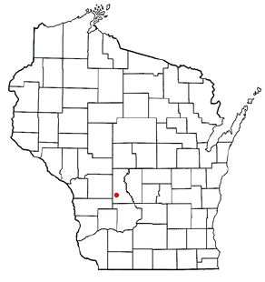
Plymouth is a town in Juneau County, Wisconsin, United States. The population was 639 at the 2000 census.

References

  1. "2023 U.S. Gazetteer Files: Mississippi". United States Census Bureau. Retrieved February 23, 2024.
  2. 1 2 "P1. Race – Potts Camp town, Mississippi: 2020 DEC Redistricting Data (PL 94-171)". U.S. Census Bureau. Retrieved February 23, 2024.
  3. Phillip Knecht, "Potts Camp (1912," Hill Country History, May 30, 2016.
  4. "US Gazetteer files: 2010, 2000, and 1990". United States Census Bureau. February 12, 2011. Retrieved April 23, 2011.
  5. "Census of Population and Housing". Census.gov. Retrieved June 4, 2015.
  6. "Explore Census Data". data.census.gov. Retrieved December 7, 2021.
  7. "U.S. Census website". United States Census Bureau . Retrieved January 31, 2008.
  8. "FORD, Aaron Lane". Biographical Directory of the United States Congress. United States Congress. Retrieved June 8, 2023.