Sadsbury Township, Chester County, Pennsylvania

Last updated

Sadsbury Township
Sadsburyville Chesco PA 3.JPG
Houses along US 30 Business
Chester County Pennsylvania incorporated and unincorporated areas Sadsbury highlighted.svg
Location in Chester County and the state of Pennsylvania.
Pennsylvania in United States (US48).svg
Location of Pennsylvania in the United States
Coordinates: 39°58′40″N75°53′57″W / 39.97778°N 75.89917°W / 39.97778; -75.89917
CountryUnited States
StatePennsylvania
County Chester
Area
[1]
  Total6.20 sq mi (16.05 km2)
  Land6.17 sq mi (15.97 km2)
  Water0.03 sq mi (0.08 km2)
Elevation
581 ft (177 m)
Population
 (2010)
  Total3,570
  Estimate 
(2016) [2]
3,880
  Density629.16/sq mi (242.92/km2)
Time zone UTC-5 (EST)
  Summer (DST) UTC-4 (EDT)
Area code(s) 610
FIPS code 42-029-67080
Website http://www.sadsburytwp.org

Sadsbury Township is a township in Chester County, Pennsylvania, United States. The population was 3,570 at the 2010 census.

Contents

Geography

According to the United States Census Bureau, the township has a total land area of 6.17 square miles (16.0 km2) with a total water area of 0.03 square miles (0.078 km2). It includes the village of Sadsburyville in the north, and the census-designated place of Pomeroy in the south.

History

The township of Sadsbury was organized in 1717. In 1728, it was divided into West Sadsbury Township and East Sadsbury Township. East Sadsbury Township was reduced in size by the creation of Valley Township in 1852, the borough of Parkesburg in 1872 and the borough of Atglen in 1875. The final division came with the inception of West Sadsbury in 1878, with the remainder being Sadsbury Township in its current form. [3]

Demographics

Historical population
CensusPop.Note
1930 1,071
1940 1,22614.5%
1950 1,50222.5%
1960 2,06637.5%
1970 2,1031.8%
1980 2,39814.0%
1990 2,5104.7%
2000 2,5822.9%
2010 3,57038.3%
2020 4,12515.5%
[4]

As of the census of 2010, there were 3,570 people, 1,311 households, and 988 families living in the township. There were 1,361 housing units, of which 1,311 were occupied. The racial makeup of the township was 84.5% White, 8.5% African American, 2.6% Asian, 0.3% Native American, 0.1% Pacific Islander, 1.2% from other races, and 2.9% from two or more races. Hispanic or Latino of any race were 4.1% of the population.

There were 1,311 households, out of which 32.4% had children under the age of 18 living with them, 60.7% were married couples living together, 10% had a female householder with no husband present, 4.7% had a male householder with no wife present, and 24.6% were non-families. 18.9% of all households were made up of individuals, and 20% had someone living alone who was 65 years of age or older. The average household size was 2.72 and the average family size was 3.1.

In the township the population had 2.9% under the age of 15, 10.7% from 15 to 24, 29.4% from 25 to 44, 29.2% from 45 to 64, and 9.7% who were 65 years of age or older. The median age was 37.4 years. 50.7% of the population were males, 49.3% were females.

The median income for a household in the township was $77,551, and the median income for a family was $78,803. Males had a median income of $50,806 versus $43,142 for females. The per capita income for the township was $31,603. 2.1% of families and 2.8% of the population were below the poverty line, including 4.5% of those under age 18 and 2.6% of those aged between 18 and 64 and nobody aged 65 and over.

Transportation

US 30 Business westbound in Sadsbury Township 2022-09-04 12 33 54 View west along U.S. Route 30 Business (Lincoln Highway) just west of Wilmington Road in Sadsbury Township, Chester County, Pennsylvania.jpg
US 30 Business westbound in Sadsbury Township

As of 2018, there were 33.02 miles (53.14 km) of public roads in Sadsbury Township, of which 11.95 miles (19.23 km) were maintained by the Pennsylvania Department of Transportation (PennDOT) and 21.07 miles (33.91 km) were maintained by the township. [5]

U.S. Route 30 is the most prominent highway serving Sadsbury Township. It follows Lincoln Highway and the Coatesville-Downingtown Bypass along a west-east alignment through the north-central portion of the township. U.S. Route 30 Business begins at the western end of the Coatesville-Downingtown Bypass and continues eastward along Lincoln Highway. Pennsylvania Route 10 follows Octorara Trail on a north-south alignment along the western edge of the township. Finally, Pennsylvania Route 372 follows Valley Road along an east-west alignment through the southeastern portion of the township.

Related Research Articles

<span class="mw-page-title-main">Robeson Township, Pennsylvania</span> Township in Pennsylvania, United States

Robeson Township is a township in Berks County, Pennsylvania, United States. The population was 7,216 at the 2010 census.

<span class="mw-page-title-main">Atglen, Pennsylvania</span> Borough in Pennsylvania, United States

Atglen is a borough in Chester County, Pennsylvania, United States. According to the 2020 census, its population is 1,311.

<span class="mw-page-title-main">Caln Township, Pennsylvania</span> Township in Pennsylvania, United States

Caln Township is a township in Chester County, Pennsylvania, United States. The population was 14,428 at the 2020 census. The township was founded by settlers from Calne, Wiltshire in England in 1714; the relationship between Calne and Wiltshire continues in the present since the two are sister cities. Caln is a township of the First Class, and the governing body is a Board of Commissioners. The township also owns Ingleside Golf Club and over 200 acres (0.81 km2) of green space and parks.

<span class="mw-page-title-main">Charlestown Township, Pennsylvania</span> Township in Pennsylvania, United States

Charlestown Township is a township in Chester County, Pennsylvania, United States. The population was 6,003 at the 2020 census.

<span class="mw-page-title-main">Downingtown, Pennsylvania</span> Borough in Pennsylvania, United States

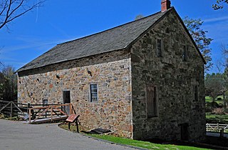
Downingtown is a borough in Chester County, Pennsylvania, United States, 33 miles (53 km) west of Philadelphia. As of the 2020 census, it had a population of 7,898. Downingtown was settled by European colonists in 1716 and has a number of historic buildings and structures.

<span class="mw-page-title-main">East Bradford Township, Pennsylvania</span> Township in Pennsylvania, United States

East Bradford Township is a township in Chester County, Pennsylvania, United States. The population was 10,308 at the 2020 census.

<span class="mw-page-title-main">East Brandywine Township, Pennsylvania</span> Township in Pennsylvania, United States

East Brandywine Township is a township in Chester County, Pennsylvania, United States. The population was 9,746 at the 2020 census.

<span class="mw-page-title-main">East Caln Township, Pennsylvania</span> Township in Pennsylvania, United States

East Caln Township is a township in Chester County, Pennsylvania, United States. The population was 5,380 at the 2020 census. The township wraps around the eastern half of Downingtown and is mostly indistinguishable from it. East Caln Township is very developed, containing several shopping centers, including the regionally important Brandywine Square Center, several recently constructed housing developments varying from condominiums to large single family homes, and some industry in the southern fringe of the township.

<span class="mw-page-title-main">East Fallowfield Township, Chester County, Pennsylvania</span> Township in Pennsylvania, United States

East Fallowfield Township is a township in Chester County, Pennsylvania, United States. The population was 7,626 at the 2020 census.

<span class="mw-page-title-main">Exton, Pennsylvania</span> Census-designated place in Pennsylvania, United States

Exton is a census-designated place (CDP) in West Whiteland Township in Chester County, Pennsylvania, United States. Its population was 5,622 at the 2020 census. The Exton Square Mall and Main Street at Exton are both located within Exton along with several other shopping centers, making Exton the major shopping district in Chester County.

<span class="mw-page-title-main">London Grove Township, Pennsylvania</span> Township in Pennsylvania, United States

London Grove Township is a township in Chester County, Pennsylvania, United States. The population was 8,797 at the 2020 census.

<span class="mw-page-title-main">New London Township, Pennsylvania</span> Township in Pennsylvania, United States

New London Township is a township that is located in Chester County, Pennsylvania, United States. It was the birthplace of U.S. Founding Father Thomas McKean.

<span class="mw-page-title-main">Parkesburg, Pennsylvania</span> Borough in Pennsylvania, United States

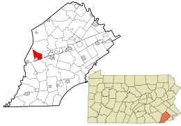
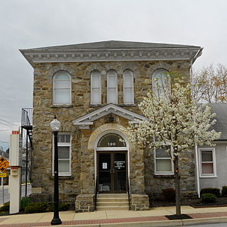
Parkesburg is a borough in Chester County, Pennsylvania, United States. The population was counted as 3,866 at the 2020 census. The ZIP code is 19365.

<span class="mw-page-title-main">Thorndale, Pennsylvania</span> Census-designated place in Pennsylvania, United States

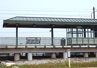
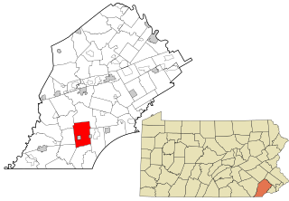
Thorndale is a census-designated place in Caln Township, Chester County, Pennsylvania, United States. The population was 3,407 at the 2010 census.

<span class="mw-page-title-main">Upper Uwchlan Township, Pennsylvania</span> Township in Pennsylvania, United States

Upper Uwchlan Township is a township in Chester County, Pennsylvania, United States. The population was 11,227 at the 2010 census. The township included the community of Milford Mills before it was inundated by the creation of the Marsh Creek Dam in 1972.

<span class="mw-page-title-main">Uwchlan Township, Pennsylvania</span> Township in Pennsylvania, United States

Uwchlan Township is a township in Chester County, Pennsylvania, United States. The population was 19,161 at the 2020 census.

<span class="mw-page-title-main">Valley Township, Chester County, Pennsylvania</span> Township in Pennsylvania, United States

Valley Township is a township in Chester County, Pennsylvania, United States. The population was 6,794 at the 2010 census.

<span class="mw-page-title-main">Wallace Township, Pennsylvania</span> Township in Pennsylvania, United States

Wallace Township is a township in Chester County, Pennsylvania, United States. The population was 3,458 at the 2010 census.

<span class="mw-page-title-main">West Pikeland Township, Pennsylvania</span> Township in Pennsylvania, United States

West Pikeland Township is a township in Chester County, Pennsylvania, United States. The population was 4,024 at the 2010 census.

<span class="mw-page-title-main">West Sadsbury Township, Pennsylvania</span> Township in Pennsylvania, United States

West Sadsbury Township is a township in Chester County, Pennsylvania, United States. The population was 2,444 at the 2010 census.

References

  1. "2016 U.S. Gazetteer Files". United States Census Bureau. Retrieved August 13, 2017.
  2. "Population and Housing Unit Estimates" . Retrieved June 9, 2017.
  3. Futhey, John Smith; Cope, Gilbert (1881). History of Chester County, Pennsylvania with Geographical and Biographical Sketches. Philadelphia, Pennsylvania: Louis H. Everts.
  4. "Census 2020".
  5. "Sadsbury Township map" (PDF). PennDOT. Retrieved March 13, 2023.