Hamorton, Pennsylvania | |
|---|---|
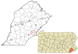 Location of Hamorton in Chester County and of Chester County in Pennsylvania | |
 Hamorton  Hamorton | |
| Coordinates: 39°52′4″N75°39′15″W / 39.86778°N 75.65417°W | |
| Country | United States |
| State | Pennsylvania |
| County | Chester |
| Township | Kennett |
| Area | |
• Total | 0.12 sq mi (0.30 km2) |
| • Land | 0.11 sq mi (0.29 km2) |
| • Water | 0.01 sq mi (0.02 km2) |
| Elevation | 460 ft (140 m) |
| Population | |
• Total | 179 |
| • Density | 1,612.61/sq mi (620.02/km2) |
| Time zone | UTC-5 (Eastern (EST)) |
| • Summer (DST) | UTC-4 (EDT) |
| ZIP Codes | |
| Area code(s) | [Area codes 610, 484, and 835[[[Category:Pages using infobox settlement with possible area code list]] |
| FIPS code | 42-32280 |
| GNIS feature ID | 2812901 [3] |
Hamorton is an unincorporated community and census-designated place (CDP) in Chester County, Pennsylvania, United States. It was first listed as a CDP prior to the 2020 census. [3]
Hamorton is located primarily in southern Chester County, in the northeastern part of Kennett Township. U.S. Route 1 passes through the community, leading east (northbound) 3 miles (5 km) to Chadds Ford and west (southbound) the same distance to Kennett Square. Pennsylvania Route 52 intersects Route 1 in Hamorton, leading southeast 10 miles (16 km) to Wilmington, Delaware, and northeast 9 miles (14 km) to West Chester.
The Hamorton Historic District, listed on the National Register of Historic Places, comprises 75 historic buildings in the northern part of the CDP along US 1.
