Related Research Articles

Chester County, colloquially known as Chesco, is a county in the U.S. state of Pennsylvania. As of the 2010 census, the population was 498,886, increasing by 5.2% to a census-estimated 524,989 residents as of 2019. The county seat is West Chester. Chester County was one of the three original Pennsylvania counties created by William Penn in 1682. It was named for Chester, England.

Drumore Township is a township in southwestern Lancaster County, Pennsylvania, United States. At the 2010 census the population was 2,560.
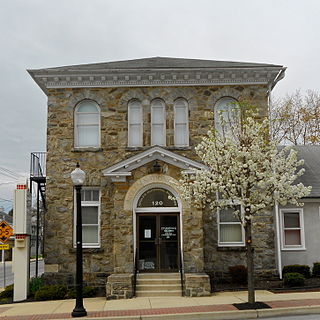
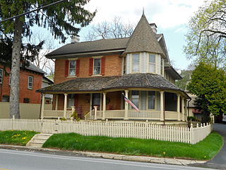
Atglen is a borough in Chester County, Pennsylvania, United States. According to the 2010 Census, its population is 1,406.

Coatesville is a city in Chester County, Pennsylvania, United States. The population was 13,100 at the 2010 census. Coatesville is approximately 39 miles west of Philadelphia. It developed along Lancaster Turnpike, beginning in the late 18th century. It spans U.S. Route 30, the "Main Line" highway that runs west of Philadelphia.
West Grove is a borough in Chester County, Pennsylvania, United States. The population was 2,854 at the 2010 census.

Brookhaven is a borough in Delaware County, Pennsylvania, United States. The population was 8,006 at the 2010 census.

Chester Heights is a borough in Delaware County, Pennsylvania, United States. The population was 2,531 at the 2010 census. Most of the borough lies south of U.S. 1, about a mile southwest of Wawa.

Marcus Hook is a borough in Delaware County, Pennsylvania, United States. The population was 2,397 at the 2010 census. The current mayor is Gene Taylor. The borough calls itself "The Cornerstone of Pennsylvania". The 2005 film One Last Thing... was set and partially filmed in Marcus Hook.

Media is a borough in and the county seat of Delaware County, Pennsylvania, United States, about 13 miles (21 km) west of Philadelphia. Media was incorporated in 1850 at the same time that it was named the county seat. The population was 5,327 at the 2010 census, down from 5,533 at the 2000 census.

Ridley Park is a borough in Delaware County, Pennsylvania, United States. The population was 7,002 at the 2010 census. Ridley Park is the home of The Boeing Company's CH-47 Chinook helicopter division.

Swarthmore is a borough in Delaware County, Pennsylvania, United States. Swarthmore was originally named "Westdale" in honor of noted painter Benjamin West, who was one of the early residents of the town. The name was changed to "Swarthmore" after the establishment of Swarthmore College. The borough population was 6,194 as of the 2010 census.
Chester Township is a township in Delaware County, Pennsylvania, United States. The population was 3,940 at the 2010 census, down from 4,604 at the 2000 census.

Nether Providence Township is a first class township in Delaware County, Pennsylvania, United States. Many residents refer to the township by the name of its largest community, Wallingford, because the Wallingford postal code is used for most of the township. The population of the township was 13,706 at the 2010 census.
West Fallowfield Christian School is a Christian school in Atglen, Chester County, Pennsylvania in the United States.
Ercildoun, population about 100, is an unincorporated community in East Fallowfield Township, Chester County, Pennsylvania, United States. The hamlet was founded by Quakers and was an early center of the abolitionist movement. In 1985 the entire hamlet, including 31 properties, was listed as a historic district on the National Register of Historic Places. Of these properties two were vacant land, 14 were significant buildings, ten were contributing buildings, and five buildings, built in the 1950s, were non-contributing. The Lukens Pierce House, an octagon house listed separately on the U.S. National Register of Historic Places, is located about half a mile northwest of the hamlet. Ercildoun is one of about ten hamlets in the township, which has no cities or towns, but has 31 sites listed on the National Register. It is one of the larger hamlets, located near the center of the township, and historically among the best known. The city of Coatesville is about 3 miles north.

The 13th Pennsylvania House of Representatives District is in southeast Pennsylvania and has been represented by John Lawrence since 2010.

Cochranville is a census-designated place (CDP) in West Fallowfield Township, Chester County, Pennsylvania, United States. The population was 668 at the 2010 census. It is the hometown of Olympic swimmer Cierra Runge.

Strasburg Road was an early road in Pennsylvania connecting Philadelphia to Strasburg in Lancaster County. The route was surveyed by John Sellers and others in 1772-3 under the colonial administration of Governor Richard Penn and completed under the new administration of the independent state of Pennsylvania. The route started at the "second ferry" on the Schuylkill River, today's Market Street in Philadelphia, and went through West Chester, East Fallowfield Township, and Gap, before ending in Strasburg. Earlier roads travelled much the same route, including a Native American path in use as early as 1620.

Mortonville is an unincorporated area and historic hamlet in Chester County, Pennsylvania on the eastern bank of the West Branch Brandywine Creek. It consists of about a half-dozen structures, two of which are on the National Register of Historic Places: the Mortonville Hotel, and the 12.5-foot-long (3.8 m) "Bridge in East Fallowfield Township" which crosses a mill race a few feet east of a larger bridge. The larger bridge, known as the Mortonville Bridge, was also listed on the NRHP until 2010 when it was delisted following a renovation. The two bridges are in East Fallowfield Township, while most other structures are in Newlin Township.
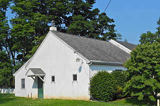
Faggs Manor is an unincorporated community in Londonderry Township, Chester County, Pennsylvania, in the United States. The hamlet, at the corner of Street Road and Faggs Manor Road includes a church and cemetery with a few nearby houses.
References
- 1 2 "Steelville, Pennsylvania". Geographic Names Information System . United States Geological Survey . Retrieved 2018-03-09.
- ↑ "Steelville, West Fallowfield Township, Chester County, Atglen PA 19310". www.livingplaces.com. Retrieved 2018-03-07.
- ↑ "Steelville (Chester County, Pennsylvania): Interactive Map". roadsidethoughts.com. Retrieved 2018-03-07.

| | This Chester County, Pennsylvania state location article is a stub. You can help Wikipedia by expanding it. |