Easttown Township, Chester County, Pennsylvania

Last updated

Easttown Township
Waterloo Mills.JPG
Chester County Pennsylvania incorporated and unincorporated areas Easttown highlighted.svg
Location in Chester County and the state of Pennsylvania.
Pennsylvania in United States (US48).svg
Location of Pennsylvania in the United States
Coordinates: 40°02′08″N75°26′22″W / 40.03556°N 75.43944°W / 40.03556; -75.43944
CountryUnited States
StatePennsylvania
County Chester
FoundedIncorporated ca. 1704
Area
[1]
  Total8.27 sq mi (21.41 km2)
  Land8.22 sq mi (21.30 km2)
  Water0.04 sq mi (0.11 km2)
Elevation
417 ft (127 m)
Population
 (2010)
  Total10,477
  Estimate 
(2016) [2]
10,594
  Density1,288.02/sq mi (497.29/km2)
Time zone UTC-5 (EST)
  Summer (DST) UTC-4 (EDT)
Area code 610
FIPS code 42-029-21928
Website www.easttown.org

Easttown Township is a township in Chester County, Pennsylvania, United States. The population was 10,984 at the 2020 census. The township, which lies in the western half of Philadelphia's Main Line suburbs, is comprised predominantly of parts of two unincorporated areas: Devon and Berwyn. A small portion of the township has a Paoli address.

Contents

History

The land that eventually became Easttown Township was once part of the Welsh Tract, a large expanse of land promised by William Penn to a group of Welsh Quaker settlers in which they would be able to speak and conduct business in the Welsh language. Whilst the autonomous entity envisaged by some was never formed, it left its mark in the many Welsh place names that still exist, such as the census-designated place (CDP) Berwyn in Easttown and adjacent Tredyffrin Township. The township is believed to have been incorporated in 1704 since that is the earliest date it has been found to be referred to in official records. However a delineated community of that name appears in Thomas Holme's ca. 1687 map. [3]

Whilst the originators of the Welsh Tract were Quakers, the earliest settlers in the portion that became Easttown Township were mostly Anglicans. St. David's Episcopal Church, just past the eastern edge of the township, was constructed in 1715 by Welsh Anglicans when the original church sent them a minister.

Revolutionary War leader Anthony Wayne was born and lived in Waynesborough house, in the western part of the township. He—or at least part of him—is buried at St. David's. [4]

A Revolutionary War skirmish that occurred along a ridge in the center of the township was the only engagement of that war in the township. The name of the British commander, Banastre Tarleton, was later given to a nearby mansion: Tarleton. [5]

Two sites in the township are listed on the National Register of Historic Places: Waynesborough and Roughwood. The cluster of buildings that forms the village of Leopard, identified as a ‘Significant Historic Cluster’ in the Chester County Historic Sites Survey (1979–1982), is eligible for listing as well. In addition, the Waterloo Mills Historic District has been designated. Although St. David's Church is just over the line in Newtown Township, the church building and its graveyard (most of which is in Easttown) are listed together in the National Register.

Easttown Township is said to have the most-litigated zoning law in Pennsylvania, largely as a result of its efforts to avoid being swallowed up by the expansion of the suburbs of Philadelphia. At least two major cases about minimum lot size were handed down by the Pennsylvania Supreme Court: Bilbar Construction [6] upheld the township's minimum lot sizes, while National Land and Investment Co. [7] struck them down as ‘exclusionary’ seven years later. National Land further held that a municipality may utilize zoning measures that are substantially related to the protection and preservation of the municipality's proper interest in providing for the general welfare of its residents, but Easttown's zoning did not pass the test. Ironically, despite the developer-litigants' claimed interest in allowing poor people to live in Easttown, they built only houses that sold at well over the average value in Pennsylvania.

Geography

According to the United States Census Bureau, the township has a total area of 8.2 square miles (21 km2), of which 0.12% is water.

The township is bordered by Radnor township (to the east), Tredyffrin township (to the north), Willistown township (to the west) and Newtown township (to the south).

Demographics

Historical population
CensusPop.Note
1930 2,570
1940 2,552−0.7%
1950 3,81149.3%
1960 6,90781.2%
1970 9,56538.5%
1980 9,064−5.2%
1990 9,5705.6%
2000 10,2707.3%
2010 10,4772.0%
2020 10,9844.8%
[8] [9]

According to the 2021 American Community Survey's five-year population estimates, the township was 82% non-Hispanic White, 1% Black or African American, 0% Native American and 11% Asian. 3% of residents reported two or more races and 3% of the population were of Hispanic or Latino ancestry. [10] 12.9% of residents were foreign-born, of whom 66% were born in Asia, 19% were born in Europe and 11% were born in Latin America. 4.8% of residents are U.S. veterans.

There were 10,924 people and 3,917 households residing in the township. The population density was 1,321 people per square mile. 87% of units were single-family homes and 79% of households were headed by a married couple. The average household size was 2.8.

The median income for a household in the township was $187,868, with 45% of households earning more than $200,000 per year. The per capita income for the township was $92,164, 2.5 times higher than the average per capita income in Pennsylvania. The median family income was $204,601, placing Easttown 9th among 2,560 municipalities in Pennsylvania. Among families with children, the median household income was higher than $250,000.

81.1% of residents over the age of 25 hold a bachelor's degree and 42% have earned a graduate degree.

The median value of owner-occupied housing units was $730,200, 3.7 times higher than the median value in the state of Pennsylvania.

Transportation

US 30 eastbound in Easttown Township 2022-09-04 17 00 15 View east along U.S. Route 30 (Lancaster Avenue) just east of Midland Avenue in Easttown Township, Chester County, Pennsylvania.jpg
US 30 eastbound in Easttown Township

As of 2018, there were 66.66 miles (107.28 km) of public roads in Easttown Township, of which 18.66 miles (30.03 km) were maintained by the Pennsylvania Department of Transportation (PennDOT) and 48.00 miles (77.25 km) were maintained by the township. [11]

U.S. Route 30 and Pennsylvania Route 252 are the numbered highways serving Easttown Township. US 30 follows Lancaster Avenue along an east-west alignment through the northern part of the township, while PA 252 follows Darby-Paoli Road and Leopard Road along a northwest-southeast alignment through the western and southern portions of the township.

Government

The township is governed by a Board of Supervisors. The present board consists of:

Education

Conestoga High School Conestoga High School.jpg
Conestoga High School

Easttown Township lies within the Tredyffrin/Easttown School District. [12] Students residing within township boundaries attend Conestoga High School for grades 9-12. Hillside Elementary School, Beaumont Elementary School and Devon Elementary school serve students in grades K-4. [13] Tredyffrin/Easttown Middle School and Valley Forge Middle School serve students in grades 5–8.

Tarleton School, a private elementary school, is located on Waterloo Avenue.

The Roman Catholic Archdiocese of Philadelphia manages area Catholic schools. St. Norbert School is in the township, [14] and is outside of the Paoli CDP, [15] but has a Paoli mailing address. It was established in 1956, with the school building built the following year. [16] In 2012 the Catholic grade school St. Monica in Berwyn closed. [17]

Easttown Township has its own public library. [18]

Parks

The township has two parks, Hilltop Park and Frank Johnson Memorial Park. [19] Hilltop, with a Devon address but outside of the Devon CDP, has a pavilion with toilets, a picnic area, two soccer fields, a "tot lot", and trails for walking purposes. [20] Johnson, in the Berwyn CDP, has a pavilion with toilets, basketball courts, an open field, a "tot lot", and volleyball courts. [21]

Notable people

Media

The HBO miniseries Mare of Easttown , which premiered on April 18, 2021, is set in a fictionalized version of Easttown Township, although it moves the location to neighboring Delaware County. The series was filmed in surrounding communities in southeastern Pennsylvania but not within Easttown Township itself. Series creator Brad Ingelsby was born and raised in Berwyn, which is partially located in Easttown Township.

Related Research Articles

<span class="mw-page-title-main">Chesterbrook, Pennsylvania</span> Census-designated place in Pennsylvania, United States

Chesterbrook is a census-designated place (CDP) in Chester County, Pennsylvania, United States. It is located within the Philadelphia metropolitan area and just south of Valley Forge National Historical Park. The population was 4,589 at the 2010 census.

Devon-Berwyn was a census-designated place (CDP) in Chester County, Pennsylvania. The population was 5,067 at the 2000 census. For the 2010 census, the area was split into two separate CDPs, Devon and Berwyn. The area is part of the Philadelphia Main Line suburbs of Philadelphia.

<span class="mw-page-title-main">East Goshen Township, Chester County, Pennsylvania</span> Township in Pennsylvania, United States

East Goshen Township is a township in Chester County, Pennsylvania, United States. The population was 18,026 at the 2010 census.

<span class="mw-page-title-main">Exton, Pennsylvania</span> Census-designated place in Pennsylvania, United States

Exton is a census-designated place (CDP) in West Whiteland Township in Chester County, Pennsylvania, United States. Its population was 5,622 at the 2020 census. The Exton Square Mall and Main Street at Exton are both located within Exton along with several other shopping centers, making Exton the major shopping district in Chester County.

<span class="mw-page-title-main">Malvern, Pennsylvania</span> Borough in Pennsylvania, United States

Malvern is a borough in Chester County, Pennsylvania, United States. Malvern is the terminus of the Philadelphia Main Line. It is 19.4 miles (31.2 km) west of Philadelphia. The population was 3,419 at the 2020 census.

<span class="mw-page-title-main">Paoli, Pennsylvania</span> Census-designated place in Pennsylvania, United States

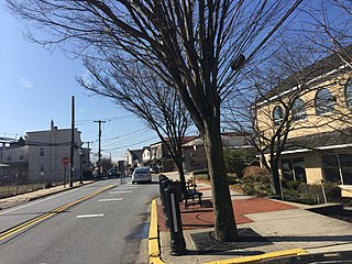
Paoli is a census-designated place (CDP) in Chester County near Philadelphia, Pennsylvania, United States. It is situated in portions of two townships: Tredyffrin and Willistown. At the 2020 census, it had a total population of 6,002.

<span class="mw-page-title-main">Tredyffrin Township, Chester County, Pennsylvania</span> Township in Pennsylvania, United States

Tredyffrin Township is a township located in eastern Chester County, Pennsylvania, United States. The population was 29,332 at the 2010 census.

<span class="mw-page-title-main">Willistown Township, Chester County, Pennsylvania</span> Township in Pennsylvania, United States

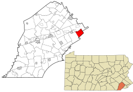
Willistown Township is a township in Chester County, Pennsylvania, United States. The population was 10,497 at the 2010 census. At the 1860 census, the population of Willistown was 1,521, and in 1980 it was 8,269.

<span class="mw-page-title-main">Newtown Township, Delaware County, Pennsylvania</span> Township in Pennsylvania, United States

Newtown Township, also referred to by the name of its post office of Newtown Square, is a township in Delaware County, Pennsylvania, United States. Prior to 1789, it was part of Chester County. As of the 2020 census, the population was 15,002.

<span class="mw-page-title-main">Eagleville, Montgomery County, Pennsylvania</span> Census-designated place in Pennsylvania, United States

Eagleville is a census-designated place (CDP) in Montgomery County, Pennsylvania, United States. The population was 4,800 at the 2010 census. It is within Lower Providence Township.

<span class="mw-page-title-main">Lower Providence Township, Montgomery County, Pennsylvania</span> Township in Pennsylvania, United States

Lower Providence Township is a township in Montgomery County, Pennsylvania, United States. The township is located approximately 17 miles northwest of Philadelphia. The population was 25,625 at the 2020 census.

<span class="mw-page-title-main">Trooper, Pennsylvania</span> Census-designated place in Pennsylvania, United States

Trooper is a census-designated place (CDP) in Lower Providence Township, Montgomery County, Pennsylvania, United States. The population was 5,744 at the 2010 census.

<span class="mw-page-title-main">Radnor Township, Delaware County, Pennsylvania</span> Township with home rule in Pennsylvania, United States

Radnor Township, often called simply Radnor, is a first class township with home rule status in Delaware County, Pennsylvania, United States. As of the 2019 United States census estimate, the township population is 31,875. Radnor Township is the largest municipality in Delaware County by land area and the fourth-largest by population, following Upper Darby Township, Haverford Township, and Chester.

<span class="mw-page-title-main">Philadelphia Main Line</span> Collection of suburban communities in Pennsylvania, United States

The Philadelphia Main Line, known simply as the Main Line, is an informally delineated historical and social region of suburban Philadelphia, Pennsylvania. Lying along the former Pennsylvania Railroad's once prestigious Main Line, it runs northwest from Center City Philadelphia parallel to Lancaster Avenue, also known as U.S. Route 30.

<span class="mw-page-title-main">Berwyn, Pennsylvania</span> Census-designated place in Pennsylvania, United States

Berwyn is a census-designated place (CDP) in Chester County, Pennsylvania, United States. Berwyn is located within Tredyffrin and Easttown Townships. The area is part of the Philadelphia Main Line suburbs.

<span class="mw-page-title-main">Devon, Pennsylvania</span> Census-designated place in Pennsylvania, United States

Devon is a census-designated place (CDP) located in Easttown township in Chester County, Pennsylvania, United States. The population was 1,515 at the 2010 census. The area is part of the Philadelphia Main Line suburbs.

<span class="mw-page-title-main">Wayne, Pennsylvania</span> Unincorporated community in Delaware County, Pennsylvania, United States

Wayne is an unincorporated community centered in Delaware County, Pennsylvania, United States, on the Main Line, a series of highly affluent Philadelphia suburbs located along the railroad tracks of the Pennsylvania Railroad and one of the wealthiest areas in the nation. While the center of Wayne is in Radnor Township, Wayne extends into both Tredyffrin Township in Chester County and Upper Merion Township in Montgomery County. The center of Wayne was designated the Downtown Wayne Historic District in 2012. Considering the large area served by the Wayne post office, the community may extend slightly into Easttown Township, Chester County, as well.

<span class="mw-page-title-main">Tredyffrin/Easttown School District</span> Public school district in Chester County, Pennsylvania

Tredyffrin/Easttown School District is a school district based in Tredyffrin Township, Chester County, Pennsylvania.

<span class="mw-page-title-main">Devon Preparatory School</span> School in Tredyffrin Township, , Chester County, Pennsylvania, United States

Devon Preparatory School is a Catholic all-male college preparatory school in Tredyffrin Township, Pennsylvania, in the United States, with a Devon postal address. Founded in 1956 by Piarists, it is divided into a middle school and an upper school, both located on the same 20 acres (8.1 ha) campus. The school operates independently under the auspices of the Roman Catholic Archdiocese of Philadelphia.

<span class="mw-page-title-main">Pennsylvania Route 252</span> State highway in Pennsylvania, US

Pennsylvania Route 252 is a north–south state highway in the U.S. state of Pennsylvania that connects PA 320 in Nether Providence Township at its southern terminus to PA 23 in Valley Forge at its northern terminus. The route runs through the western suburbs of Philadelphia in Delaware, Chester, and Montgomery counties, including Nether Providence Township, the borough of Media, Upper Providence Township, Marple Township, Newtown Township, Easttown Township, Tredyffrin Township, and Upper Merion Township. The route intersects many roads including U.S. Route 1 north of Media, PA 3 in Newtown Square, US 30 in Paoli, and US 202 near Berwyn.

References

  1. "2016 U.S. Gazetteer Files". United States Census Bureau. Retrieved August 13, 2017.
  2. "Population and Housing Unit Estimates" . Retrieved June 9, 2017.
  3. Holme, Thomas, A Mapp of Ye Improved Part of Pensilvania in America, Divided Into Countyes, Townships and Lotts (ca. 1687).
  4. Hugh T. Harrington and Lisa A. Ennis. "Mad" Anthony Wayne: His Body Did Not Rest in Peace. http://www.americanrevolution.org/wayne.html, citing History of Erie County, Pennsylvania, vol. 1. pp. 211-2. Warner, Beers & Co., Chicago. 1884.
  5. "Battle in Chesco pitted notable foes Capt. Henry Lee of the Continental Army and British Maj. Banastre Tarleton faced off in 1778. Local History". philly-archives.
  6. Bilbar Construction Co. v. Easttown Twp., 393 Pa. 62, 141 A.2d 851 (1958).
  7. National Land and Investment Co. v. Easttown Twp. Bd. of Adjustment, 419 Pa. 504, 215 A.2d 597 (1965).
  8. "DVRPC > Site Search". Archived from the original on April 9, 2019. Retrieved March 21, 2014.
  9. "Census 2020".
  10. "US Census". US Census .
  11. "Easttown Township map" (PDF). PennDOT. Retrieved March 13, 2023.
  12. "Map." Easttown Township, Chester County, Pennsylvania. Retrieved on October 9, 2018. Alternate URL
  13. "TESDmap2015.pdf." Tredyffrin/Easttown School District. Retrieved on October 9, 2018.
  14. "Zoning Map". Easttown Township. Retrieved May 6, 2020.
  15. "2010 CENSUS - CENSUS BLOCK MAP: Paoli CDP, PA."U.S. Census Bureau. Retrieved on October 9, 2018.
  16. "History". St. Norbert School. November 6, 2017. Retrieved May 6, 2020.
  17. "2012 Catholic grade school consolidations/closings". Catholicphilly.com. July 15, 2012. Retrieved April 22, 2020.
  18. Home. Easttown Library & Information Center. Retrieved on October 9, 2018.
  19. "Parks." Easttown Township. Retrieved on October 9, 2018.
  20. "Hilltop Park." Easttown Township. Retrieved on October 9, 2018. "The Park is located at 580 Beaumont Road in Devon." - See: "2010 CENSUS - CENSUS BLOCK MAP: Devon CDP, PA." U.S. Census Bureau. Retrieved on October 9, 2018.
  21. "Johnson Park." Easttown Township. Retrieved on October 9, 2018. "The park is located at 122 Bridge Avenue in Berwyn." - See: "2010 CENSUS - CENSUS BLOCK MAP: Berwyn CDP, PA." U.S. Census Bureau. Retrieved on October 9, 2018.