Willowdale, Pennsylvania

Last updated

Willowdale, Pennsylvania
Unincorporated community
Willowdale Post Office and General Store.jpg
Willowdale Post Office and General Store
USA Pennsylvania location map.svg
Red pog.svg
Willowdale
Location in Pennsylvania
Usa edcp location map.svg
Red pog.svg
Willowdale
Location in United States
Coordinates: 39°52′27″N75°43′04″W / 39.87417°N 75.71778°W / 39.87417; -75.71778
Country United States
State Pennsylvania
County Chester
Township East Marlborough
Time zone UTC-5 (Eastern (EST))
  Summer (DST) UTC-4 (EDT)

Willowdale is an unincorporated community that is located in East Marlborough Township, in southern Chester County, Pennsylvania, United States. [1]

Contents

It was named after a grove of Willow trees that grew in the general area when the community was originally settled. Several businesses, shopping centers and residential developments in the general area of the crossroads have since been named after Willowdale.

History

1700s

Originally, the crossroads in this area was called Taggarts Crossroads. It was named after the Taggart family, who owned a stone inn there. Built in 1730, that inn is still extant on the northwestern corner of the crossroads.

Another eighteenth-century house, a quaint fieldstone house that stands on the northeastern section of the crossroads, was once described in an article as the "Oldest House West of the Brandywine." While that description has since been proven to be inaccurate, due to the dating of other homesteads in the region, this fieldstone house is still considered by area historians to be an historic structure.

During the morning of September 11, 1777, British forces under Lord Charles Cornwallis' marched directly through the quiet crossroads. Cornwallis, using a flanking maneuver, surprise troops commanded by Washington, a move that enabled Cornwallis to avert a confrontation with Washington's main force at Chadds Ford.

When Cornwallis reached the crossroads, he encountered a small party of American troops commanded by Lieutenant Colonel James Ross of the 8th Pennsylvania Regiment. Ross, who headed one of the many picket lines deployed that day, fired three shots before retreating. He later followed the rearguard of the British army, skirmishing with them along the Great Valley Road before reporting his findings of a flanking maneuver to Washington. [2]

1800s

Rakestraw Pyle Nursery, Willowdale; a small stone chapel near the intersection at Street Road is in the background beyond the water tower Earlyphoto.jpg
Rakestraw Pyle Nursery, Willowdale; a small stone chapel near the intersection at Street Road is in the background beyond the water tower

During the nineteenth century, the crossroads grew as the nearby Du Pont Factory increased its manufacture of black powder. The black powder, which was 15% charcoal, needed the process of burning trees to produce the power and the willow trees from Willowdale were among the best to burn.

As a result of the town's growth, a post office, general store, church, wheelwright shop, blacksmith, and church were erected during the late nineteenth century in and around the crossroads.

In 1866, Josiah Pyle and William Rakestraw, both landowners in the crossroads, formed the Rakeshaw-Pyle nurseries on the northeast of the crossroads near the present-day Willowdale Church. The property included a greenhouse, water tower, and gardens. The business still exists in the same area today and is known as RP Nursies. [3]

1900s

During the twentieth century, the community's growth continued. In 1906, a trolley line was built by the West Chester Street Rail company through the present-day crossroads and following the Unionville Road. The service, which originated in Kennett Square, stopped at the station at the general store near the crossroads at Willowdale, and ran ten minutes before and after each hour throughout the day.

A trolley switch between the chapel building and the station allowed two trolley cars to pass by each other, going in opposite directions to and from Kennett Square. The trolley ran through the area until 1929, when a bus route replaced the service. Today, one can still see the outline of the trolley line on the stone wall lining on the left side of the Unionville Road, driving southwards.

Willowdale Church Oldchurchphoto.jpg
Willowdale Church

Around that same time, the church had outgrown its original building and a larger structure was built, directly across from the original church. The congregation still exists today, with services each Sunday.

During the latter part of the twentieth century, as Chester County was becoming increasingly suburbanized, growth of the crossroads area surged again. The area occupying the northeastern side of the crossroads was developed, and the original general store and various outbuildings were razed. The barn and stone house were also converted into an office space.

Today, this area is known for varying commercial services such as food, health, financing, and local state government offices. Still, the intersection retains much of its rural appearance, as it essentially acts as the boundary between suburban and rural Pennsylvania due to much of the land West of the crossroads being majority farmland. In contrast, land east of the crossroads is home the majority of housing developments.

Pyle General Store and the trolly line operated by the West Chester Street Rail Company from 1904 until 1929 Coloredearlyphoto.jpg
Pyle General Store and the trolly line operated by the West Chester Street Rail Company from 1904 until 1929

Geography

Willowdale is located at 39° 52' 27" North, 75° 43' 5" West. [1]

It is located at the crossroads of Pennsylvania Routes 926 and 82, between Kennett Square and Unionville. It is situated close to Longwood Gardens and is a twenty-minute drive from downtown Wilmington, Delaware.

Education

Willowdale is located in the Unionville-Chadds Ford School District.

Local attractions

Willowdale Steeplechase: The Willowdale Steeplechase Races are sanctioned by the National Steeplechase Association and attract some of the best racehorses and top jockeys from around the world. Set in a natural amphitheater, the course features traditional European hedges, post, and rail fences and a water jump.

Longwood Gardens (An international garden destination located approximately five minutes from Willowdale): 1,050 acres (4.2 km2) of gardens, woodlands, and meadows; twenty outdoor gardens; twenty indoor gardens within four acres (16,000 m²) of heated greenhouses; 11,000 different types of plants; fountains.

Brandywine Battlefield (Located approximately fifteen minutes from Willowdale): A permanent interpretive exhibit and an audio-visual presentation at this museum's visitor center tell the story of the Battle of Brandywine and explain its connection to the Philadelphia Campaign of 1777. Changing exhibits cover other topics of interest. American Revolution.

Related Research Articles

<span class="mw-page-title-main">Chester County, Pennsylvania</span> County in Pennsylvania, United States

Chester County is a county in the Commonwealth of Pennsylvania. It is located in the Delaware Valley region, located in the southeastern part of the state. As of the 2020 census, the population was 534,413, increasing by 7.1% from 498,886 in 2010. The county seat and most populated municipality is West Chester. Chester County was one of the three original Pennsylvania counties created by William Penn in 1682. It was named for Chester, England.

<span class="mw-page-title-main">Birmingham Township, Chester County, Pennsylvania</span> Township in Pennsylvania, United States

Birmingham Township is a township in Chester County, Pennsylvania, United States. The population was 4,085 at the 2020 census.

<span class="mw-page-title-main">East Marlborough Township, Chester County, Pennsylvania</span> Township in Pennsylvania, United States

East Marlborough Township is a township in Chester County, Pennsylvania, United States. The population was 7,026 at the 2010 census. East Marlborough and West Marlborough townships were carved out of the larger Marlborough Township in 1729. The township is home to many Penn Oak trees, trees that were in existence when William Penn explored the area.

<span class="mw-page-title-main">Kennett Square, Pennsylvania</span> Borough in Pennsylvania, United States

Kennett Square is a borough in Chester County, Pennsylvania, United States. As of the 2020 U.S. census, Kennett Square had a population of 5,943.

<span class="mw-page-title-main">Pennsbury Township, Pennsylvania</span> Township in Pennsylvania, United States

Pennsbury Township is a township in Chester County, Pennsylvania, United States. The population was 3,604 at the 2010 census.

<span class="mw-page-title-main">Battle of Brandywine</span> 1777 battle of the American Revolutionary War

The Battle of Brandywine, also known as the Battle of Brandywine Creek, was fought between the American Continental Army of General George Washington and the British Army of General Sir William Howe on September 11, 1777, as part of the American Revolutionary War (1775–1783). The forces met near Chadds Ford, Pennsylvania. More troops fought at Brandywine than at any other battle of the American Revolution. It was also the second longest single-day battle of the war, after the Battle of Monmouth, with continuous fighting for 11 hours.

<span class="mw-page-title-main">Brandywine Creek (Christina River tributary)</span> Creek in Pennsylvania and Delaware, US

Brandywine Creek is a tributary of the Christina River in southeastern Pennsylvania and northern Delaware in the United States. The Lower Brandywine is 20.4 miles (32.8 km) long and is a designated Pennsylvania Scenic River with several tributary streams. The East Branch and West Branch of the creek originate within 2 miles (3 km) of each other on the slopes of Welsh Mountain in Honey Brook Township, Pennsylvania, about 20 miles (32 km) northwest of their confluence.

<span class="mw-page-title-main">Chadds Ford Township, Pennsylvania</span> Township in Pennsylvania, United States

Chadds Ford Township is an affluent township in Delaware County, Pennsylvania, United States. It is located about 25 miles (40 km) southwest of Philadelphia.

<span class="mw-page-title-main">Pennsylvania Route 52</span> State highway in Chester County, Pennsylvania, US

Pennsylvania Route 52 is a 11.8-mile-long (19.0 km) state highway located in southeast Pennsylvania. The southern terminus of the route is at the Pennsylvania-Delaware state line near Kennett Square, where the road continues as Delaware Route 52. The northern terminus is at U.S. Route 322 Business in West Chester. Near the Kennett Township community of Longwood, it has about a 1-mile (1.6 km) wrong-way concurrency with US 1. PA 52 passes through suburban and rural areas along its route.

<span class="mw-page-title-main">Unionville-Chadds Ford School District</span> School district in Pennsylvania, United States

Unionville-Chadds Ford School District (UCFSD) is a school district in southeastern Chester County and western Delaware County, Pennsylvania, a 77-square-mile (200 km2) area encompassing seven townships and serving a total of abpproximately 4,000 students.

<span class="mw-page-title-main">Unionville, Chester County, Pennsylvania</span> Census-designated place in Pennsylvania, United States

Unionville is an unincorporated community and census-designated place in East Marlborough Township in southern Chester County, Pennsylvania, United States. It was originally known as Jacksonville. The Unionville Village Historic District was added to the National Register of Historic Places in 1979. As of 2020, the CDP has a population of 577.

The Baltimore Pike was an auto trail connecting Baltimore, Maryland, with Philadelphia, Pennsylvania.

<span class="mw-page-title-main">Pennsylvania Route 82</span> State highway in Chester County, Pennsylvania, United States

Pennsylvania Route 82 is a 32-mile-long (51 km) north–south state highway located in Chester County in southeast Pennsylvania, USA. The southern terminus is at the Delaware state line southeast of Kennett Square, where the road continues south into that state as Delaware Route 82. The northern terminus is at PA 23 in Elverson. PA 82 heads through rural areas of Chester County along with the communities of Kennett Square, Unionville, and Coatesville. The route intersects many important roads including U.S. Route 1 near Kennett Square, PA 162 and PA 842 in Unionville, US 30 in Coatesville, and US 322 in Brandywine Manor. PA 82 is a two-lane undivided road most of its length.

<span class="mw-page-title-main">Unionville High School (Kennett Square, Pennsylvania)</span> Public high school in Kennett Square, Chester County, Pennsylvania, United States

A four-year, high school located in Kennett Square, Pennsylvania, Unionville High School enrolls approximately 1,300 students. Accredited by the Middle Atlantic States Association of Secondary Schools, and the Commonwealth of Pennsylvania, Unionville High School has received state recognition for excellence and high achievement in the preparation of students for higher education.

<span class="mw-page-title-main">Brandywine School</span>

The Brandywine School was a style of illustration—as well as an artists colony in Wilmington, Delaware and in Chadds Ford, Pennsylvania, near the Brandywine River—both founded by artist Howard Pyle (1853–1911) at the end of the 19th century. The works produced there were widely published in adventure novels, magazines, and romances in the early 20th century. Pyle’s teachings would influence such notable illustrators as N.C. Wyeth, Maxfield Parrish, Harvey Dunn, and Norman Rockwell. Pyle himself would come to be known as the "Father of American Illustration." Many works related to the Brandywine School may be seen at the Brandywine River Museum of Art, in Chadds Ford.

The Brandywine Battlefield Historic Site is a National Historical Landmark. The historic park is owned and operated by the Pennsylvania Historical and Museum Commission, on 52 acres (210,000 m2), near Chadds Ford, Delaware County, Pennsylvania in the United States.

<span class="mw-page-title-main">N. C. Wyeth House and Studio</span> Historic house in Pennsylvania, United States

The N. C. Wyeth House and Studio is a historic house museum and artist's studio on Murphy Road in Chadds Ford Township, Pennsylvania, United States. Beginning with its construction in 1911, it served as the principal home and studio of artist N.C. Wyeth (1882-1945). It was restored to its original appearance around the time of his death. The property is managed by the Brandywine River Museum, which offers tours. It was designated a National Historic Landmark District in 1997.

<span class="mw-page-title-main">Old Kennett Meetinghouse</span> Historic church and cemetery in Chester County, Pennsylvania

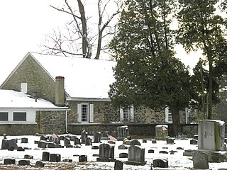
Old Kennett Meetinghouse is a historic meeting house of the Religious Society of Friends or "Quakers" in Kennett Township near Chadds Ford, Pennsylvania.

<span class="mw-page-title-main">Trimbleville Historic District</span> Historic district in Pennsylvania, United States

Trimbleville, Pennsylvania, also known as Trimble's Ford and the Trimbleville Historic District is a hamlet of roughly six homes that is located in southern Chester County, Pennsylvania, approximately two miles south of Marshallton.

<span class="mw-page-title-main">Dilworthtown Historic District</span> Historic district in Pennsylvania, United States

Dilworthtown Historic District is a national historic district located in Dilworthtown, Birmingham Township, Chester County, Pennsylvania. It encompasses eight contributing buildings in the crossroads community of Dilworthtown. They include the Dilworth House, stone house (1820), Dilworthtown Lyceum or meeting hall, Dilworthtown Store (1858), two tenant houses, and a two-story log cabin dated to 1686 or the early-18th century. The focal point of the district is the Dilworth House, also known as the Dilworthtown Inn, which has operated as an inn and tavern since the late 18th century. The town was at the center of the fighting during the Battle of Brandywine in September 1777.

References

  1. 1 2 "Geographic Names Information System". edits.nationalmap.gov. Retrieved September 26, 2022.
  2. "Founders Online: II: From Lieutenant Colonel James Ross, 11 September 1777".
  3. "R-P Nurseries - Home" . Retrieved October 11, 2023.