West Grove, Pennsylvania

Last updated
West Grove, Pennsylvania
House in West Grove, PA 1.JPG
House in West Grove
Nickname: 
Home of the Roses
Chester County Pennsylvania incorporated and unincorporated areas West Grove highlighted.svg
Location in Chester County and the U.S. state of Pennsylvania
USA Pennsylvania location map.svg
Red pog.svg
West Grove
Location in Pennsylvania
Usa edcp location map.svg
Red pog.svg
West Grove
Location in the United States
Coordinates: 39°49′18″N75°49′36″W / 39.82167°N 75.82667°W / 39.82167; -75.82667
CountryUnited States
StatePennsylvania
County Chester
IncorporatedNovember 29, 1893
Area
[1]
  Total0.65 sq mi (1.69 km2)
  Land0.65 sq mi (1.69 km2)
  Water0.00 sq mi (0.00 km2)
Elevation
430 ft (130 m)
Population
 (2020) [2]
  Total2,775 Decrease2.svg
  Estimate 
(2021) [2]
2,767
  Density4,360.98/sq mi (1,684.03/km2)
Time zone UTC-5 (EST)
  Summer (DST) UTC-4 (EDT)
ZIP Code
19390
Area code(s) 610 and 484
FIPS code 42-83104
Website www.westgroveborough.org

West Grove is a borough in Chester County, Pennsylvania, United States. The population was 2,775 at the 2020 census. [2]

Contents

History

The village of West Grove derived its name from the Friends Meeting House on Harmony Road built in 1787 several miles west of the Friends Meeting House in the village of London Grove. West Grove was separated from London Grove Township and became an incorporated borough on November 29, 1893. However, the decree of incorporation was not recorded until January 9, 1894, to prevent confusing the tax accounts of London Grove Township and to eliminate the need for a special borough election.

The move for incorporation followed several years of significant growth in West Grove that began to develop with the coming of the Philadelphia and Baltimore Central Railroad in 1860. On March 28, 1885, the Daily Local News described West Grove as "one of the most flourishing villages in this county" and stated that "it contains some three flouring mills and the largest nursery for rose culture [see below] in the United States (Dinger & Conrad, Co.), a large casket factory (Paxson Comfort) and a large number of dwellings." In May 1885, the Chester County Democrat reported that thirty new homes were under construction in the village of West Grove.

The "Father of West Grove" was Joseph Pyle. Born in Penn Township in 1836, Joseph Pyle opened a general store in 1860 in the brick building that is currently empty. This building was constructed by Pyle and is believed to be the oldest brick structure in the center of town. Joseph Pyle constructed many of the commercial buildings along the present-day Exchange Place, including the Roselyn Theater Building in 1867 (torn down in 1980), the National Bank of West Grove building in 1883 and the K&P Building in 1885. Appointed postmaster of the borough by President Lincoln in 1864, Pyle served twenty-two years. Furthermore, Pyle introduced the manufacture of brick, planned and installed the first public water system, was President of the West Grove Improvement Company which financed the construction of the casket factory in 1885, served on Borough Council and was Burgess (Mayor) from 1900 to 1903.

The first election of borough officials was held in the West Grove Hotel on February 20, 1894. John P. Cheyney was elected the first burgess (mayor) in what amounted to a Democratic landslide. The Democrats won every office, including mayor, six school directors, two squires, constable, assessor and tax collector, two assistant assessors, three auditors, town clerk and high constable. The first council meeting was held March 6, 1894, in the Library Room on the second floor of the National Bank Building on Exchange Place. The current mayor of West Grove is Stephen B. Black, Republican, who has been in office since August 2000.

Home of the Roses

Our new guide to rose culture, Dingee & Conard Co. catalog, 1899 Our new guide to rose culture (16443497232).jpg
Our new guide to rose culture, Dingee & Conard Co. catalog, 1899

In 1868 Charles Dingee and Alfred Fellenberg Conard founded the Dingee & Conard Nursery, a commercial grower of fruit trees, roses and other nursery products. In the late 1880s the West Grove Post Office was the second largest in Chester County, mostly due to the volume of nursery products shipped by Dingee & Conard.

Located near the borough of West Grove is the Red Rose Inn, which was established in 1740. William Penn originally granted land for the inn subject to an annual rent payment of one red rose. The inn was subsequently renamed in honor of this event.

Geography

West Grove is located at 39°49′18″N75°49′36″W / 39.82167°N 75.82667°W / 39.82167; -75.82667 (39.821783, -75.826672). [3]

According to the United States Census Bureau, the borough has a total area of 0.6 square miles (1.6 km2), all land.

West Grove is on the boundary between hardiness zones 6b and 7a. The climate is hot-summer humid continental (Dfa.)

Transportation

PA 841 southbound in West Grove 2022-09-06 16 53 11 View south along Pennsylvania State Route 841 (Prospect Avenue) just south of Evergreen Street in West Grove, Chester County, Pennsylvania.jpg
PA 841 southbound in West Grove

As of 2010, there were 8.97 miles (14.44 km) of public roads in West Grove, of which 1.55 miles (2.49 km) were maintained by Pennsylvania Department of Transportation (PennDOT) and 7.42 miles (11.94 km) were maintained by the borough. [4]

Pennsylvania Route 841 is the only numbered highway directly serving West Grove. It follows a north-south alignment through the eastern part of the borough via Prospect Avenue, Evergreen Street and Chatham Road. U.S. Route 1 bypasses the borough to the north.

Demographics

Historical population
CensusPop.Note
1880 269
1900 929
1910 1,26135.7%
1920 1,152−8.6%
1930 1,37519.4%
1940 1,357−1.3%
1950 1,52112.1%
1960 1,6075.7%
1970 1,87016.4%
1980 1,820−2.7%
1990 2,12816.9%
2000 2,65224.6%
2010 2,8547.6%
2020 2,775−2.8%
2021 (est.)2,767 [2] −0.3%
[5]

At the 2010 census, the borough was 56.7% non-Hispanic White, 6.0% Black or African American, 0.8% Native American, 0.8% Asian, and 2.5% were two or more races. 35.2% of the population were of Hispanic or Latino ancestry .

As of the census [6] of 2000, there were 2,652 people, 864 households, and 679 families residing in the borough. The population density was 4,177.6 inhabitants per square mile (1,613.0/km2). There were 889 housing units at an average density of 1,400.4 per square mile (540.7/km2). The racial makeup of the borough was 78.73% White, 8.37% African American, 0.41% Native American, 9.77% from other races, and 2.71% from two or more races. Hispanic or Latino of any race were 17.01% of the population.

Of the borough's 864 households, 45.3% included children under the age of 18, 59.4% were married couples living together, 14.6% had a female householder with no husband present, and 21.4% were non-families. 16.7% of all households consisted of solo individuals, and 6.7% of those living alone were 65 years of age or older. The average household size was 3.05 and the average family size was 3.39.

The age distribution of borough residents comprised 31.1% under the age of 18, 9.1% from 18 to 24, 35.7% from 25 to 44, 15.9% from 45 to 64, and 8.1% who were 65 years of age or older. The median age was 32 years. For every 100 females there were 95.9 males. For every 100 females age 18 and over, there were 93.8 males.

The median income for a household in the borough was $56,875, and the median income for a family was $60,274. Males had a median income of $43,657 versus $30,144 for females. The per capita income for the borough was $19,967. About 4.7% of families and 8.3% of the population were below the poverty line, including 5.5% of those under age 18 and 11.1% of those age 65 or over.

See also

Related Research Articles

<span class="mw-page-title-main">Turtle Creek, Pennsylvania</span> Borough in Pennsylvania, United States

Turtle Creek is a borough in Allegheny County, Pennsylvania, United States, 12 miles (19 km) southeast of Pittsburgh. The population was 5,114 at the 2020 census. George Westinghouse constructed a manufacturing plant nearby. Turtle Creek takes its name from a small stream that flows into the Monongahela River. Before white settlers arrived, there was a small village of Native Americans living there from the Turtle Clan of the Iroquois Nation.

<span class="mw-page-title-main">St. Lawrence, Pennsylvania</span> Borough in Pennsylvania, United States

St. Lawrence, is a borough in Berks County, Pennsylvania, United States. The population was 1,809 at the 2010 census. It sits just east of Mount Penn and Reading. It is served by the Exeter Township School District.

<span class="mw-page-title-main">Weatherly, Pennsylvania</span> Borough in Pennsylvania, United States

Weatherly is a borough in Carbon County, Pennsylvania, United States. It is part of Northeastern Pennsylvania and is located 12 miles (19 km) northwest of Jim Thorpe and 28 miles (45 km) south of Wilkes-Barre.

<span class="mw-page-title-main">Kennett Square, Pennsylvania</span> Borough in Pennsylvania, United States

Kennett Square is a borough in Chester County, Pennsylvania, United States. As of the 2020 U.S. census, Kennett Square had a population of 5,943.

<span class="mw-page-title-main">Modena, Pennsylvania</span> Borough in Pennsylvania, United States

Modena is a borough in Chester County, Pennsylvania, United States. The population was 544 at the 2020 census. It was originally called Modeville, after the local Mode family.

<span class="mw-page-title-main">Oxford, Pennsylvania</span> Borough in Pennsylvania, United States

Oxford is a borough in Chester County, Pennsylvania, United States. Oxford is the closest town to Lincoln University. The population was 5,733 at the 2020 census.

<span class="mw-page-title-main">Parkesburg, Pennsylvania</span> Borough in Pennsylvania, United States

Parkesburg is a borough in Chester County, Pennsylvania, United States. The population was counted as 3,866 at the 2020 census. The ZIP code is 19365.

<span class="mw-page-title-main">Penn Township, Chester County, Pennsylvania</span> Township in Pennsylvania, United States

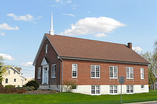
Penn Township is a township that is located in Chester County, Pennsylvania, United States. It is home to the Nursery Capital of Pennsylvania and was the site of Sunset Park, one of country music's most popular venues.

<span class="mw-page-title-main">South Coatesville, Pennsylvania</span> Borough in Pennsylvania, United States

South Coatesville is a borough that is located in Chester County, Pennsylvania, United States. The population was 1,604 at the ime of the 2020 census.

<span class="mw-page-title-main">Spring City, Pennsylvania</span> Borough in Pennsylvania, United States

Spring City is a borough in Chester County, Pennsylvania, United States. The population was 3,494 at the 2020 census. Spring City is a member of the Spring-Ford Area School District.

<span class="mw-page-title-main">Chester Heights, Pennsylvania</span> Borough in Pennsylvania, United States

Chester Heights is a borough in Delaware County, Pennsylvania, United States. The population was 2,531 at the 2010 census. Most of the borough lies south of U.S. 1, about a mile southwest of Wawa.

<span class="mw-page-title-main">Morton, Pennsylvania</span> Borough in Pennsylvania, United States

Morton is a borough in Delaware County, Pennsylvania, United States. The population was 2,778 at the 2020 census.

<span class="mw-page-title-main">Parkside, Pennsylvania</span> Borough in Pennsylvania, United States

Parkside is a borough in Delaware County, Pennsylvania, United States. The population was 2,328 at the 2010 census.

<span class="mw-page-title-main">Prospect Park, Pennsylvania</span> Borough in Pennsylvania, United States

Prospect Park is a borough in Delaware County, Pennsylvania, United States. The population was 6,454 at the 2010 census, down from 6,594 at the 2000 census. It originated as a bedroom community of Philadelphia. It is located within 10 miles (16 km) of Center City, Philadelphia, with convenient rail access.

<span class="mw-page-title-main">Rutledge, Pennsylvania</span> Borough in Pennsylvania, United States

Rutledge is a borough in Delaware County, Pennsylvania, United States. The population was 782 at the 2020 census, down from 860 at the 2000 census.

<span class="mw-page-title-main">Trainer, Pennsylvania</span> Borough in Pennsylvania, United States

Trainer is a borough in Delaware County, Pennsylvania, United States. The population was 1,828 at the 2010 census, down from 1,901 at the 2000 census. The borough was named after David Trainer, a wealthy textile manufacturer.

<span class="mw-page-title-main">Upland, Pennsylvania</span> Borough in Pennsylvania, United States

Upland is a borough in Delaware County, Pennsylvania, United States. Upland is governed by an elected seven-member borough council. The population was 3,239 at the 2010 census, up from 2,974 at the 2000 census.

<span class="mw-page-title-main">West Conshohocken, Pennsylvania</span> Borough in Pennsylvania, United States

West Conshohocken is a borough in Montgomery County, Pennsylvania, United States. The population was 1,320 at the 2010 census.

<span class="mw-page-title-main">Spring Grove, Pennsylvania</span> Borough in Pennsylvania, United States

Spring Grove is a borough in York County, Pennsylvania, United States. The population was 2,372 at the 2020 census.].

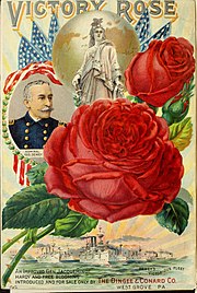
Star Roses and Plants/Conard-Pyle, is a horticultural products company, based in West Grove, Pennsylvania since 1855. The company introduced the Peace rose to America from Europe, and always specialized in rose production, but at one time, they were the leading Canna grower and hybridizer in the United States. Star Roses and Plants/Conard-Pyle is best known for introducing the Knock Out Family of Roses and Drift Roses.

References

  1. "2019 U.S. Gazetteer Files". United States Census Bureau. Retrieved July 28, 2020.
  2. 1 2 3 4 Bureau, US Census. "City and Town Population Totals: 2020-2021". Census.gov. US Census Bureau. Retrieved 12 July 2022.
  3. "US Gazetteer files: 2010, 2000, and 1990". United States Census Bureau. 2011-02-12. Retrieved 2011-04-23.
  4. "West Grove Borough map" (PDF). PennDOT. Retrieved March 12, 2023.
  5. "Census 2020".
  6. "U.S. Census website". United States Census Bureau . Retrieved 2008-01-31.