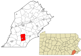
London Grove Township is a township in Chester County, Pennsylvania, United States. The population was 8,797 at the 2020 census.

West Chester is a borough and the county seat of Chester County, Pennsylvania, United States. Located within the Philadelphia metropolitan area, the borough had a population of 18,461 at the 2010 census. West Chester is the mailing address for most of its neighboring townships. When calculated by mailing address, the population as of the 2010 U.S. Census was 108,696, which would make it the 10th largest city by mailing address in the state of Pennsylvania.

Pennsylvania's 6th congressional district is a district in the state of Pennsylvania. It includes all of Chester County, the city of Reading, and Reading's southeastern suburbs in Berks County. The district is represented by Democrat Chrissy Houlahan, who has served in Congress since 2019. As currently drawn, the district is among the wealthiest in Pennsylvania. The Supreme Court of Pennsylvania redrew the district in February 2018 after ruling the previous map unconstitutional.

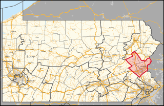
Pennsylvania's 7th congressional district includes all of Carbon, Lehigh, and Northampton Counties; and parts of Monroe County. The district is represented by Democrat Susan Wild.

Pennsylvania's 16th congressional district is located in Northwestern Pennsylvania. It contains all of Erie County, Crawford County, Mercer County, and Lawrence County, as well as part of Butler County. The district is represented by Republican Mike Kelly.

Pennsylvania Route 41 is a 22-mile-long (35 km) state highway located in southeastern Pennsylvania, United States. The southern terminus of the route is at the Delaware state line in Kennett Township, where the road continues as Delaware Route 41. The northern terminus is at U.S. Route 30 in Gap. PA 41 runs along a two-lane undivided road called Gap Newport Pike, passing through mostly rural areas of Chester and Lancaster counties and serving Avondale, Chatham, Cochranville, and Atglen. The route serves as part of the main road linking Wilmington, Delaware to Lancaster, Pennsylvania.

Pennsylvania Route 841 is a state highway in Chester County, Pennsylvania. The route runs from the Maryland border in the community of Lewisville in Elk Township, where the road continues as Maryland Route 213, north to PA 82 in the community of Doe Run in West Marlborough Township. The route heads through rural areas of southwestern Chester County on a two-lane undivided road. PA 841 passes through West Grove, where it has an interchange with U.S. Route 1. PA 841 was first assigned to an unpaved road running from Springdell to PA 82 in 1928. The route was extended south to its current terminus in 1937 and was completely paved by 1940.
Russellville is an unincorporated community in Upper Oxford Township in Chester County, Pennsylvania, United States. Russellville is located at the intersection of state routes 10 and 896.
Springdell is an unincorporated community in West Marlborough Township in Chester County, Pennsylvania, United States. Springdell is located at the intersection of Pennsylvania Route 841 and Spring Dell Road.
Pocopson is an unincorporated community in Pocopson Township in Chester County, Pennsylvania, United States. Pocopson is located at the intersection of Pennsylvania Route 926 and Pocopson Road.
Devault is an unincorporated community in Charlestown Township in Chester County, Pennsylvania, United States. Devault is located at the intersection of Pennsylvania Route 29, Phoenixville Pike, and Charlestown Road.
Goshenville is an unincorporated community in East Goshen Township in Chester County, Pennsylvania, United States. Goshenville is located at the intersection of Pennsylvania Route 352 and Paoli Pike.
Lenape is an unincorporated community in Pocopson Township in Chester County, Pennsylvania, United States. Lenape is centered on the intersection of Pennsylvania Route 52 and Pocopson Road, west of the Brandywine Creek.
Mendenhall is an unincorporated community in Kennett Township in Chester County, Pennsylvania, United States. Mendenhall is located at the intersection of Pennsylvania Route 52 and Hillendale Road.
Lewisville is an unincorporated community in Elk Township in Chester County, Pennsylvania, United States. Lewisville is located at the intersection of state routes 472 and 841, just north of the Maryland border.
Chesterville is an unincorporated community in Franklin Township in Chester County, Pennsylvania, United States. Chesterville is located at the intersection of Pennsylvania Route 841, Chesterville Road, and North Creek Road.
Kelton is an unincorporated community in Penn Township in Chester County, Pennsylvania, United States. Kelton is located at the intersection of Pennsylvania Route 796 and Kelton Road.

Sadsburyville is an unincorporated area in Sadsbury Township in Chester County, Pennsylvania, United States. Sadsburyville is located at the intersection of U.S. Route 30 Business and Old Wilmington Road about 4 miles west of Coatesville and about 3 miles northeast of Parkesburg.
Suplee is an unincorporated community in Honey Brook Township in Chester County, Pennsylvania, United States. Suplee is located along Suplee Road, east of Honey Brook.
Darlington Corners is an unincorporated community in Thornbury and Westtown townships in Chester County, Pennsylvania, United States. Darlington Corners is located at the intersection of U.S. Route 202/U.S. Route 322 and Pennsylvania Route 926, south of West Chester.


