Lionville, Pennsylvania

Last updated

Lionville, Pennsylvania
Lionville Snowman.JPG
House and snowman in Lionville
Chester County Pennsylvania incorporated and unincorporated areas Lionville highlighted.svg
Location in Chester County and the U.S. state of Pennsylvania.
Coordinates: 40°03′10″N75°38′43″W / 40.05278°N 75.64528°W / 40.05278; -75.64528
Country United States
State Pennsylvania
County Chester
Township Uwchlan
Area
[1]
  Total2.49 sq mi (6.44 km2)
  Land2.48 sq mi (6.41 km2)
  Water0.01 sq mi (0.03 km2)
Elevation
541 ft (165 m)
Population
 (2020) [2]
  Total6,582
  Density2,658.32/sq mi (1,026.49/km2)
Time zone UTC-5 (EST)
  Summer (DST) UTC-4 (EDT)
ZIP code
19353
Area codes 610 and 484
FIPS code 42-43744

Lionville is a census-designated place (CDP) in Uwchlan Township, Chester County, Pennsylvania, United States. The population was 6,189 at the 2010 census. [3] Prior to 2010 the CDP was recorded as Lionville-Marchwood. "Marchwood", however, refers only to the housing development begun in the early 1960s that is located south of the 100-113 intersection.

Contents

Lionville is bisected by two major local highways, PA 100 and PA 113. The area contains residential neighborhoods, hotels, restaurants, and other businesses. The original name of the village was Welsh Pool, but to honor the local Red Lion Inn the name was changed to Lionville, since a borough of Red Lion, Pennsylvania, already existed. The area of Lionville along Village Avenue is a protected historic district. The Friends Meeting House was used as a hospital by the Continental Army during the American Revolutionary War.

Lionville has an independent ZIP code and post office, but it has never had mail delivery. Many of the long-term residents who picked up mail at the now-closed general store or fire station locations now use a Downingtown address. Because much of the area also falls under the Exton ZIP code, many Lionville businesses use the Exton name instead, especially if they do not have other locations in the area.

Geography

Lionville-Marchwood is located at 40°3′10″N75°38′43″W / 40.05278°N 75.64528°W / 40.05278; -75.64528 (40.052833, -75.645237). [4]

According to the United States Census Bureau, the CDP has a total area of 2.5 square miles (6.5 km2), all land.

Demographics

Historical population
CensusPop.Note
2000 6,298
2010 6,189−1.7%
2020 6,5826.3%
[5] [2]

At the 2000 census, [6] there were 6,298 people, 2,574 households and 1,719 families residing in the CDP. The population density was 2,542.9 inhabitants per square mile (981.8/km2). There were 2,645 housing units at an average density of 1,068.0 per square mile (412.4/km2). The racial makeup of the CDP was 92.32% White, 2.56% African American, 0.11% Native American, 3.72% Asian, 0.02% Pacific Islander, 0.27% from other races, and 1.02% from two or more races. Hispanic or Latino of any race were 1.21% of the population.

There were 2,574 households, of which 32.6% had children under the age of 18 living with them, 55.9% were married couples living together, 8.8% had a female householder with no husband present, and 33.2% were non-families. 26.1% of all households were made up of individuals, and 4.4% had someone living alone who was 65 years of age or older. The average household size was 2.45 and the average family size was 3.02.

24.7% of the population were under the age of 18, 6.4% from 18 to 24, 34.6% from 25 to 44, 25.2% from 45 to 64, and 9.1% who were 65 years of age or older. The median age was 36 years. For every 100 females, there were 96.3 males. For every 100 females age 18 and over, there were 91.6 males.

The median household income was $63,677 and the median family income was $73,500. Males had a median income of $51,294 compared with $33,199 for females. The per capita income for the CDP was $33,003. About 1.0% of families and 1.9% of the population were below the poverty line, including none of those under age 18 and 6.1% of those age 65 or over.

Education

Lionville is located in the Downingtown Area School District. [7]

The Lionville area is home to three schools: Lionville Elementary (outside of the CDP), Lionville Middle (in the CDP), and Downingtown East High School (outside of the CDP).

Lionville CDP is zoned to Lionville Elementary, [8] Lionville Middle, and Downingtown East High. [9]

Related Research Articles

<span class="mw-page-title-main">West Carson, California</span> Place in California, United States

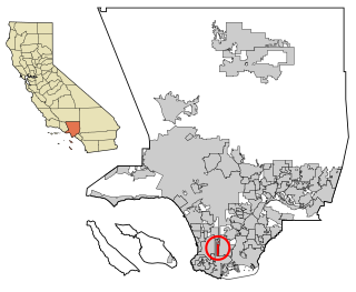
West Carson is an unincorporated community in Los Angeles County, California. The population was 22,870 at the 2020 census. For statistical purposes, the United States Census Bureau has defined West Carson as a census-designated place (CDP).

<span class="mw-page-title-main">Woodacre, California</span> Census-designated place in California, United States

Woodacre is an unincorporated town and census-designated place (CDP) in Marin County, California, United States. The population was 1,410 at the 2020 census.

<span class="mw-page-title-main">Rodney Village, Delaware</span> CDP in Delaware, United States

Rodney Village is a census-designated place (CDP) in Kent County, Delaware, United States. It is part of the Dover, Delaware Metropolitan Statistical Area. The population was 1,487 at the 2010 census.

<span class="mw-page-title-main">Brookside, Delaware</span> CDP in Delaware, United States

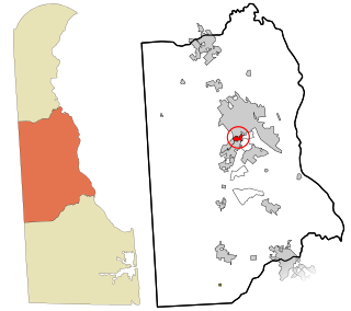
Brookside is a census-designated place (CDP) in New Castle County, Delaware, United States. The population was 14,353 at the 2010 census.

<span class="mw-page-title-main">Bunche Park, Florida</span> Neighborhood of Miami Gardens in Miami-Dade, Florida, United States

Bunche Park is a neighborhood in Miami Gardens, Florida, United States. It was formerly a census-designated place.

<span class="mw-page-title-main">Kendall West, Florida</span> Census-designated place in Florida

Kendall West is a census-designated place and unincorporated community in Miami-Dade County, Florida, west of the Florida Turnpike. It is located in the Miami metropolitan area of South Florida. The population was 36,536 at the 2020 census.

<span class="mw-page-title-main">Westwood Lakes, Florida</span> Census-designated place in Florida

Westwood Lakes is a census-designated place and unincorporated community of Miami-Dade County, Florida, United States. It is part of the Miami metropolitan area of South Florida. The population was 11,373 at the 2020 census.

<span class="mw-page-title-main">Redan, Georgia</span> CDP in Georgia, United States

Redan is a census-designated place (CDP) in DeKalb County, Georgia, United States. As of the 2020 census, the CDP had a total population of 31,749. It is a predominantly African American community in eastern DeKalb County, and is a suburb of Atlanta.

<span class="mw-page-title-main">Waimalu, Hawaii</span> Census-designated place in Hawaii, United States

Waimalu is a census-designated place (CDP) in Honolulu County, Hawaiʻi, United States. The population was 13,817 at the 2020 census.

<span class="mw-page-title-main">Marlton, Maryland</span> Census-designated place in Maryland

Marlton is an unincorporated area and census-designated place (CDP) in Prince George's County, Maryland, United States. The population was 9,802 at the 2020 census. The Marlton housing development, at first briefly called "Brandywine Country", grew up along U.S. Route 301 in the 1970s, and is part of the greater Upper Marlboro community. Originally made up of only single-family homes, more recently townhouses have been added.

<span class="mw-page-title-main">Pine Ridge, Citrus County, Florida</span> Census-designated place in Florida, US

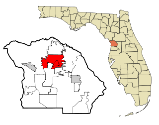
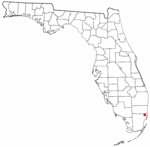
Pine Ridge is an unincorporated community and census-designated place (CDP) in Citrus County, Florida, United States. The population was 9,598 at the 2010 census, up from 5,490 in 2000.

<span class="mw-page-title-main">Downingtown, Pennsylvania</span> Borough in Pennsylvania, United States

Downingtown is a borough in Chester County, Pennsylvania, United States, 33 miles (53 km) west of Philadelphia. As of the 2020 census, it had a population of 7,898. Downingtown was settled by European colonists in the early 18th century and has a number of historic buildings and structures.

<span class="mw-page-title-main">East Caln Township, Chester County, Pennsylvania</span> Township in Pennsylvania, United States

East Caln Township is a township in Chester County, Pennsylvania, United States. The population was 5,380 at the 2020 census. The township wraps around the eastern half of Downingtown and is mostly indistinguishable from it. East Caln Township is very developed, containing several shopping centers, including the regionally important Brandywine Square Center, several recently constructed housing developments varying from condominiums to large single family homes, and some industry in the southern fringe of the township.

<span class="mw-page-title-main">Exton, Pennsylvania</span> Census-designated place in Pennsylvania, United States

Exton is a census-designated place (CDP) in West Whiteland Township in Chester County, Pennsylvania, United States. Its population was 5,622 at the 2020 census. The Exton Square Mall and Main Street at Exton are both located within Exton along with several other shopping centers, making Exton the major shopping district in Chester County.

<span class="mw-page-title-main">Thorndale, Pennsylvania</span> Census-designated place in Pennsylvania, United States

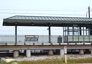
Thorndale is a census-designated place in Chester County, Pennsylvania, United States. The population was 3,407 at the 2010 census. Thorndale is the commercial and administrative center of Caln Township. The community's main street is U.S. Route 30 Business. Many of Thorndale's old houses fell into disrepair from the late 1990s to present and have been torn down and replaced with new businesses. Thorndale is historically notable for containing a summer house of US President James Buchanan, which still stands and has been incorporated into a golf course and turned into a restaurant. The community contains the Thorndale Fire Station and Caln Elementary School, part of the Coatesville Area School District. Thorndale sits along SEPTA's Paoli/Thorndale Line and is currently the last station stop on that line. It is also served by the SEPTA Route 135 bus.

<span class="mw-page-title-main">Upper Uwchlan Township, Pennsylvania</span> Township in Pennsylvania, United States

Upper Uwchlan Township is a township in Chester County, Pennsylvania, United States. The population was 11,227 at the 2010 census. The township included the community of Milford Mills before it was inundated by the creation of the Marsh Creek Dam in 1972.

<span class="mw-page-title-main">Uwchlan Township, Pennsylvania</span> Township in Pennsylvania, United States

Uwchlan Township is a township in Chester County, Pennsylvania, United States. The population was 19,161 at the 2020 census.

<span class="mw-page-title-main">Wallace Township, Pennsylvania</span> Township in Pennsylvania, United States

Wallace Township is a township in Chester County, Pennsylvania, United States. The population was 3,458 at the 2010 census.

Ranchitos Las Lomas is a census-designated place (CDP) in Webb County, Texas, United States. The population was 266 at the 2010 census. Las Lomas means "the hills" in Spanish. The town prides itself as "the place where nothing ever happened."

<span class="mw-page-title-main">West Springfield, Virginia</span> Census-designated place in Virginia, United States

West Springfield is a census-designated place (CDP) in Fairfax County, Virginia, United States. The population was 23,369 at the 2020 census.

References

  1. "ArcGIS REST Services Directory". United States Census Bureau. Retrieved October 12, 2022.
  2. 1 2 "Census Population API". United States Census Bureau. Retrieved October 12, 2022.
  3. "Profile of General Population and Housing Characteristics: 2010 Demographic Profile Data (DP-1): Lionville CDP, Pennsylvania". United States Census Bureau . Retrieved August 21, 2012.
  4. "US Gazetteer files: 2010, 2000, and 1990". United States Census Bureau. February 12, 2011. Retrieved April 23, 2011.
  5. "Census 2020".
  6. "U.S. Census website". United States Census Bureau . Retrieved January 31, 2008.
  7. "2010 CENSUS - CENSUS BLOCK MAP: Lionville CDP, PA" (PDF). U.S. Census Bureau . Retrieved June 18, 2021. - Compare with school locations and maps.
  8. "Elementary Attendance Boundaries" (PDF). Downingtown Area School District . Retrieved June 18, 2021. - Compare to the CDP map.
  9. "Secondary Attendance Boundaries" (PDF). Downingtown Area School District . Retrieved June 18, 2021. - Compare to the CDP map.