
Charles A. Lindbergh State Park is a 569-acre (2.3 km2) Minnesota state park on the outskirts of Little Falls. The park was once the farm of Congressman Charles August Lindbergh and his son Charles Lindbergh, the famous aviator. Their restored 1906 house and two other farm buildings are within the park boundaries. The house, a National Historic Landmark, and an adjacent museum are operated by the Minnesota Historical Society, known as the Charles Lindbergh House and Museum. Three buildings and three structures built by the Works Progress Administration in the 1930s were named to the National Register of Historic Places. These buildings include a picnic shelter and a water tower, built in the Rustic Style from local stone and logs, and have remained relatively unchanged since construction. Although the property includes shoreline on the Mississippi River, the Lindbergh family requested that the park not include intensive use areas for swimming or camping, so development was kept to a minimum.

This is a list of sites in Minnesota which are included in the National Register of Historic Places. There are more than 1,700 properties and historic districts listed on the NRHP; each of Minnesota's 87 counties has at least 2 listings. Twenty-two sites are also National Historic Landmarks.
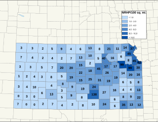
There are over 1,400 buildings, sites, districts, and objects in Kansas listed on the National Register of Historic Places in Kansas. NRHP listings appear in 101 of the state's 105 counties.
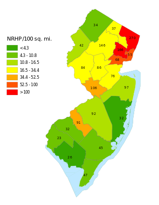
This is a list of properties and districts listed on the National Register of Historic Places in New Jersey. There are more than 1,700 listed sites in New Jersey. Of these, 58 are further designated as National Historic Landmarks. All 21 counties in New Jersey have listings on the National Register.
This National Park Service list is complete through NPS recent listings posted July 28, 2023.

Burr Oak is an unincorporated community in Winneshiek County, Iowa, United States, very close to the Minnesota state line. Burr Oak is a census-designated place and the population was 166 in the 2010 census.
This is a list of the National Register of Historic Places listings in Hamilton County, Ohio.

The Neet Covered Bridge is a Burr Arch single span structure that was built by Joseph J. Daniels in 1904 over Little Raccoon Creek southwest of Rockville, Indiana.
Union Township is one of ten townships in Marshall County, Indiana, United States. As of the 2010 census, its population was 3,088 and it contained 1,938 housing units.

Noble Township is one of thirteen townships in Noble County, Indiana. As of the 2010 census, its population was 3,094 and it contained 1,642 housing units.

List of the National Register of Historic Places listings in Mercer County, New Jersey

This is a list of the National Register of Historic Places listings in Olmsted County, Minnesota. It is intended to be a complete list of the properties and districts on the National Register of Historic Places in Olmsted County, Minnesota, United States. The locations of National Register properties and districts for which the latitude and longitude coordinates are included below, may be seen in an online map.

Greenwood is an unincorporated community in Albemarle County, Virginia, United States. It is home to the Greenwood Country Store and the Greenwood Community Center, which has the area's only roller skating rink. Greenwood has a post office with ZIP code 22943 The Greenwood Tunnel, built by Claudius Crozet for the Blue Ridge Railroad and used by the Chesapeake and Ohio Railway until its abandonment during World War II, is near Greenwood by the Buckingham Branch Railroad tracks.

The Union Covered Bridge State Historic Site is a Missouri State Historic Site in Monroe County, Missouri. The covered bridge is a Burr-arch truss structure built in 1871 over the Elk Fork of the Salt River. It was almost lost to neglect in the 1960s, but was added to the state park system in 1967, the same year it was damaged by a flood. Repairs were made the next year, using timbers salvaged from another covered bridge that had been destroyed by the same flood. In 1970, it was closed to vehicular traffic and was added to the National Register of Historic Places. Further repairs were made in 1988, and it survived the Great Flood of 1993, only to be damaged by another flood in 2008 and later re-repaired. It is about 120 feet (37 m) or 125 feet (38 m) long, 12 feet (3.7 m) high, and 17.5 feet (5.3 m) wide.

This is a list of the National Register of Historic Places listings in Fillmore County, Minnesota. It is intended to be a complete list of the properties and districts on the National Register of Historic Places in Fillmore County, Minnesota, United States. The locations of National Register properties and districts for which the latitude and longitude coordinates are included below, may be seen in an online map.

This is a list of the National Register of Historic Places listings in Jasper County, South Carolina.
This is a list of the National Register of Historic Places listings in Williamson County, Tennessee.

There are 75 properties listed on the National Register of Historic Places in Albany, New York, United States. Six are additionally designated as National Historic Landmarks (NHLs), the most of any city in the state after New York City. Another 14 are historic districts, for which 20 of the listings are also contributing properties. Two properties, both buildings, that had been listed in the past but have since been demolished have been delisted; one building that is also no longer extant remains listed.

Historic Oak View, also known as the Williams-Wyatt-Poole Farm, is a 19th-century historic farmstead and national historic district located east of downtown Raleigh, North Carolina, United States. Founded as a forced-labor farm worked by black people enslaved by the land's white owners, Oak View features an early 19th-century kitchen, 1855 farmhouse, livestock barn, cotton gin barn, and tenant house dating to the early 20th century. The Farm History Center located on site provides information to visitors regarding the history of the Oak View and the general history of farming in North Carolina. Aside from the historic buildings, the site also features an orchard, a honey bee hive, a small cotton field, and the largest pecan grove in Wake County.

Duck Creek Aqueduct, also known as the Metamora Aqueduct and Whitewater Canal Aqueduct, is a historic aqueduct carrying the Whitewater Canal over Duck Creek in Metamora Township, Franklin County, Indiana. Built in 1846, it is the only surviving covered wood aqueduct in the United States. The aqueduct was listed on the National Register of Historic Places and designated a National Historic Landmark in 2014. It is located in the Whitewater Canal Historic District and part of the Metamora Historic District.
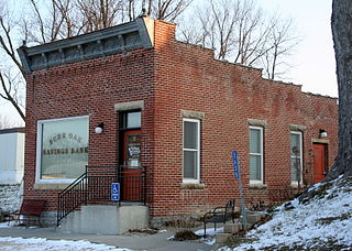
Burr Oak Savings Bank – also known as the Burr Oak Post Office – is an historic building located in Burr Oak, Iowa, United States. The free-standing, single-story, brick structure was built in 1910 in the Italianate style. Its primary decorative feature is a panel with corbeled brickwork in a dentil-like pattern, and the bracketed tin cornice above it. In 1931 it suffered a robbery, being the first robbery in Winneshiek County. That same year – as well as in 1941, 1955 and 1967 – the building underwent expansions. After the bank closed, the building was used as a barber shop and the post office, which closed in 1981. In 2014 it became the Visitors Center for the Laura Ingalls Wilder Museum and Park. It is the only building that remains on Burr Oak's main street from a period of economic expansion in early 20th-century Iowa, based on agricultural production and land values. It was listed on the National Register of Historic Places in 2001.


