Catlin Covered Bridge

Last updated
Catlin Covered Bridge
Catlin Covered Bridge.jpg
Catlin Covered Bridge
Coordinates 39°47′29.93″N87°14′17.31″W / 39.7916472°N 87.2381417°W / 39.7916472; -87.2381417
CarriesPedestrian traffic (Not open to vehicular traffic)
CrossesBill Diddle Creek
LocaleRockville Golf Course, Rockville,
Adams Township, Parke County, Indiana
Official nameCatlin Bridge
Named for Catlin, Indiana
WGCB # 14-61-15 [1]
Characteristics
Design Burr arch truss bridge
MaterialConcrete (foundations)
Trough constructionWood
Total length72 ft (21.9 m) (includes 9 ft (2.7 m) overhangs on each end)
Width16 ft (4.9 m)
Longest span54 ft (16.5 m)
No. of spans1
Clearance above 13 ft (4.0 m)
Catlin Covered Bridge (#13)
Locator map of Parke County, Indiana.svg
Red pog.svg
Location of Catlin Covered Bridge
USA Indiana location map.svg
Red pog.svg
Location of Catlin Covered Bridge
Usa edcp location map.svg
Red pog.svg
Location of Catlin Covered Bridge
Built1907 (1907)
Built byClark McDaniel
Website Catlin Bridge
Part ofParke County Covered Bridges TR (ID64000193)
NRHP reference No. 78000387 [2]
Added to NRHPDecember 22, 1978
Location
Catlin Covered Bridge

The Catlin Covered Bridge is a single span Burr Arch truss covered bridge structure that was built by Clark McDaniel in 1907.

Contents

History

Originally it was located on the Rockville–Rosedale Road on the north side of Caitlin crossing Sunderland Creek. 39°41′56″N87°14′13″W / 39.698868°N 87.236938°W / 39.698868; -87.236938 (Original Catlin Bridge location) This road had originally been a major route to Crawfordsville, even having the title the "Ben Hur Highway", for General Lew Wallace who was a famous Crawfordsville resident and author of the famous novel Ben Hur . Even after US Highway 41 was completed heavy agricultural truck traffic continued to use the bridge. This led the bridge being condemned in the late 1950s, and closed. After the bridge was closed, it fell into a severe state of disrepair. Funds were raised to save the valuable covered bridge and it was relocated to its present spot, at the Rockville Golf Course, in 1961 by Garrard Brothers Trucking where it crosses Bill Diddle Creek. [3] [4]

It was added to the National Register of Historic Places in 1978. [2]

See also

Related Research Articles

<span class="mw-page-title-main">Parke County, Indiana</span> County in Indiana, United States

Parke County lies in the western part of the U.S. state of Indiana along the Wabash River. The county was formed in 1821 out of a portion of Vigo County. According to the 2020 census, the population was 16,156. The county seat is Rockville.

<span class="mw-page-title-main">Adams Township, Parke County, Indiana</span> Township in Indiana, United States

Adams Township is one of thirteen townships in Parke County, Indiana, United States. As of the 2010 census, its population was 5,825 and it contained 2,062 housing units.

<span class="mw-page-title-main">Mansfield Covered Bridge</span> Bridge in Indiana, United States

The Mansfield Covered Bridge is a Double Burr Arch double span truss bridge located on Mansfield Road (historic) and Big Raccoon Creek in Mansfield southeast of Rockville in Parke County, Indiana. Built by Joseph J. Daniels in 1867 at a cost of $12,200. At 279 ft (85 m) it is the second longest covered bridge left in Parke County. This Historic Site rest on land provided by Indiana DNR, of Parke County, Indiana and is open to the public all year.

<span class="mw-page-title-main">Nevins Covered Bridge</span> Place in Indiana listed on National Register of Historic Places

The Nevins Covered Bridge is a single span Burr Arch Truss covered bridge that crosses Little Raccoon Creek on County Road 130 East, just southeast of Catlin, Indiana. It was built in 1920 by Joseph A. Britton and Son. Prior to the reconstruction of the Bridgeton Bridge in 2006, the Nevins Bridge was the newest covered bridge in Parke County.

<span class="mw-page-title-main">Crooks Covered Bridge</span> Bridge in Parke County, Indiana

The Crooks Covered Bridge is a single span Burr Arch Truss structure that crosses Little Raccoon Creek built in 1855-1856 by Henry Wolf just southeast of Rockville, Indiana.

<span class="mw-page-title-main">Beeson Covered Bridge</span> Bridge in Parke County, Indiana

The Beeson Covered Bridge originally crossed Roaring Creek, one mile (1.6 km) northwest of Marshall, Indiana, on County Road 216, in Washington Township, Parke County. The bridge was moved to its current location in Billie Creek Village in December 1979.

<span class="mw-page-title-main">Billie Creek Covered Bridge</span> Bridge in Parke County, Indiana

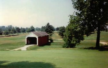
The Billie Creek Covered Bridge is a Burr Arch structure that was built by Joseph J. Daniels in 1895. J.L. Van Fossen supplied the sandstone that makes up the abutments cut from A.E. Fuel's nearby quarry.

<span class="mw-page-title-main">Neet Covered Bridge</span> Place in Indiana listed on National Register of Historic Places

The Neet Covered Bridge is a Burr Arch single span structure that was built by Joseph J. Daniels in 1904 over Little Raccoon Creek southwest of Rockville, Indiana.

<span class="mw-page-title-main">Leatherwood Station Covered Bridge</span> Place in Indiana listed on National Register of Historic Places

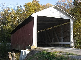
The Leatherwood Station Covered Bridge is a single span double Burr Arch Truss covered bridge structure that was built by Joseph A. Britton & Son in 1899. Originally it had sandstone abutments but when it was moved to Billie Creek Village they were replaced with concrete abutments with sandstone showing.

<span class="mw-page-title-main">Melcher Covered Bridge</span> Place in Indiana listed on National Register of Historic Places

The Melcher Covered Bridge, also known as the "Klondyke Covered Bridge", "Marion Covered Bridge", or the "Leatherwood Covered Bridge" crosses Leatherwood Creek east of Montezuma, Indiana, and is a single-span Burr Arch Truss covered bridge structure that was built by Joseph J. Daniels in 1896.

<span class="mw-page-title-main">Portland Mills Covered Bridge</span> Bridge in Indiana, United States

The Portland Mills Covered Bridge is the second oldest covered bridge in Parke County, Indiana, being built the same year as the Crooks Covered Bridge. It is a single span Burr Arch Truss covered bridge that was built by Henry Wolf in 1856.

<span class="mw-page-title-main">Rush Creek Covered Bridge</span> Place in Indiana listed on National Register of Historic Places

The Rush Creek Covered Bridge is south of Tangier, Indiana. The single span Burr Arch covered bridge structure was built by William Hendricks in 1904.

<span class="mw-page-title-main">Sanitorium Covered Bridge</span> Place in Indiana listed on National Register of Historic Places

The Sanitorium Covered Bridge is a bridged located east of Rockville, Indiana. The single-span Burr Arch covered bridge structure was built by Joseph A. Britton in 1913.

<span class="mw-page-title-main">Thorpe Ford Covered Bridge</span> Place in Indiana listed on National Register of Historic Places

The Thorpe Ford Covered Bridge is northeast of Rosedale, Indiana. The single span Burr Arch Truss covered bridge structure was built by Joseph A. Britton in 1912.

<span class="mw-page-title-main">West Union Covered Bridge (Indiana)</span> Place in Indiana listed on National Register of Historic Places

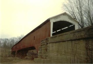
The West Union Covered Bridge formerly carried Tow Path Road over Sugar Creek north-northeast of Montezuma, Indiana. The two-span Burr Arch Truss covered bridge structure was built by Joseph J. Daniels in 1876. It is notable for being the longest standing covered bridge in Parke County, and one of the nation's best-preserved examples of the Burr truss.

<span class="mw-page-title-main">Wilkins Mill Covered Bridge</span> Place in Indiana listed on National Register of Historic Places

The Wilkins Mill Covered Bridge is north of Rockville, Indiana, United States. The single span Burr Arch Truss covered bridge structure was built by William Hendricks in 1906. The bridge is 120 feet (37 m) long, 16 feet (4.9 m) wide, and 13 feet (4.0 m) high.

<span class="mw-page-title-main">Raccoon Township, Parke County, Indiana</span> Township in Indiana, United States

Raccoon Township is one of thirteen townships in Parke County, Indiana, United States. At the 2010 census, its population was 659 and it had 345 housing units.

Joseph Albert Britton (1839–1929), most commonly known as J.A. Britton, was a builder of bridges in Indiana. He created many works that survive and are listed on the U.S. National Register of Historic Places.

Billie Creek Village was a 70-acre open-air living history museum and park, filled with 38 historical buildings and structures, and hundreds of antiques and artifacts. It is located at 39.7614298°N 87.2019582°W near Rockville, Adams Township, Parke County, Indiana in the area known as the "Covered Bridge Capital of the World" for the county's 31 covered bridges. It was formed in 1964/1965 by residents of Parke County, and opened its doors in 1969. The group Parke County, Inc. helped to form it, and a separate group, Billie Creek Village, Inc, was formed for operating it. The village took its name from nearby Williams Creek.

The Jessup Covered Bridge was north of Jessup, Indiana. The single-span Burr Arch covered bridge structure was built by the Jefferson P. Van Fossen in 1910 and destroyed by flood in 1989.

References

  1. "The Catlin Bridge". Indiana Covered Bridge Society. Retrieved 1 July 2021.
  2. 1 2 "National Register Information System  Catlin Covered Bridge (#13) (#78000387)". National Register of Historic Places . National Park Service. January 23, 2007. Retrieved September 25, 2018.
  3. "Catlin Covered Bridge (#13)". coveredbridges.com. Parke County Incorporated / Parke County Convention and Visitors Commission. Retrieved 25 November 2019.
  4. "Indiana State Historic Architectural and Archaeological Research Database (SHAARD)" (Searchable database). Department of Natural Resources, Division of Historic Preservation and Archaeology. Retrieved 2016-06-01.Note: This includes Charles Felkner (December 1977). "National Register of Historic Places Inventory Nomination Form: Parke County Covered Bridge Historic District" (PDF). Retrieved 2016-06-01., Site map, and Accompanying photographs.

Commons-logo.svg Media related to Catlin Covered Bridge at Wikimedia Commons