Cox Ford Covered Bridge

Last updated
Cox Ford Covered Bridge
Cox Ford Bridge, IN 2.jpg
Cox Ford Bridge
Coordinates 39°53′7.6″N87°13′25.64″W / 39.885444°N 87.2237889°W / 39.885444; -87.2237889 Coordinates: 39°53′7.6″N87°13′25.64″W / 39.885444°N 87.2237889°W / 39.885444; -87.2237889
CarriesCox Ford Road
Crosses Sugar Creek
Locale Sugar Creek, Indiana, Parke, Indiana, United States
Official nameCox Ford Covered Bridge
Named for Cox Ford
Maintained byParke County Commissioners
Parke County
WGCB # 14-61-34 [1]
Characteristics
Design Burr arch truss bridge
MaterialConcrete on top of stone block (foundations)
Trough constructionWood
Total length176 ft (53.6 m) (includes 8 ft (2.4 m) overhangs on each end)
Width16 ft (4.9 m)
Longest span160 ft (48.8 m)
No. of spans1
Clearance above 13 ft (4.0 m)
Cox Ford Covered Bridge (#7)
Locator map of Parke County, Indiana.svg
Red pog.svg
Location of Cox Ford Covered Bridge
USA Indiana location map.svg
Red pog.svg
Location of Cox Ford Covered Bridge
Usa edcp location map.svg
Red pog.svg
Location of Cox Ford Covered Bridge
Built1913 (1913)
Built by Joseph A. Britton
Website Conley's Ford Bridge
Part ofParke County Covered Bridges TR (ID64000193)
NRHP reference No. 78000390 [2]
Added to NRHPDecember 22, 1978
Location
Cox Ford Covered Bridge

The Cox Ford Covered Bridge is a covered bridge that crosses Sugar Creek along the western edge of Turkey Run State Park, in Parke County, in the U.S. state of Indiana.

Contents

History

This single span Burr Arch truss structure has a length of 160 ft (49 m), or 176 ft (54 m) including the 8 ft (2.4 m) overhang at each end, with a portal clearance 16 ft (4.9 m) wide by 13 ft (4.0 m) in height. Built in 1913 by Joseph A. Britton, the Cox Ford Covered Bridge has a rather unusual distinction as it was built to replace a steel bridge lost in the 1913 flood; the arches used to construction this structure were from the Armiesburg Covered Bridge, built 60 years earlier and also washed out during the 1913 flood. [3] [4]

During the Great Depression, the Cox Ford Covered Bridge received a new coat of paint that was applied by a Works Progress Administration group, and though no historical marker is present, the bridge was listed on the National Register of Historic Places in 1978. It is listed in the 1989 World Guide to Covered Bridges, published by The National Society for the Preservation of Covered Bridges, Inc., as #14-61-34; however, the designation used by Parke County officials is #14-61-36. In the February 1938 Indiana History Bulletin, Robert B. Yule and Richard C. Smith assigned the designation 'sg' to this Covered Timber Bridge located in Section 28, Township 17 North, and Range 7 West, about 1/2 a mile west of Turkey Run State Park. [5]

See also

Related Research Articles

<span class="mw-page-title-main">Turkey Run State Park</span> United States historic place

Turkey Run State Park, Indiana's second state park, is in Parke County in the west-central part of the state along State Road 47, 2 miles (3.2 km) east of U.S. 41.

<span class="mw-page-title-main">Mansfield Covered Bridge</span> Bridge in Indiana, United States

The Mansfield Covered Bridge is a Double Burr Arch double span truss bridge located on Mansfield Road (historic) and Big Raccoon Creek in Mansfield southeast of Rockville in Parke County, Indiana. Built by Joseph J. Daniels in 1867 at a cost of $12,200. At 279 ft (85 m) it is the second longest covered bridge left in Parke County. This Historic Site rest on land provided by Luke Moody, of Parke County, Indiana and is open to the public all year.

<span class="mw-page-title-main">Big Rocky Fork Covered Bridge</span> Place in Indiana listed on National Register of Historic Places

The Big Rocky Fork Covered Bridge is located 1 mile (1.6 km) southeast of Mansfield, Indiana, on County Road 720 and about 2 miles (3.2 km) east of State Road 59, in Parke County.

<span class="mw-page-title-main">Conley's Ford Covered Bridge</span> Bridge in Parke County, Indiana

Conley's Ford Covered Bridge was built in 1906 and crosses Big Raccoon Creek on County Road 550 East close to County Road 720 South, in Parke County, IN. The bridge is a single span Burr Arch Truss structure. The Conley's Ford Covered Bridge was built by J. Lawrence Van Fossen.

<span class="mw-page-title-main">Bridgeton Covered Bridge</span> Bridge in Bridgeton, Indiana

The first Bridgeton covered bridge was a double-span Burr Arch bridge built in 1868 by a crew led by J. J. Daniels. It was closed to traffic in 1967. It was built to replace two prior open wooden bridges that had fallen in. After its destruction by fire, it was replaced in 2006 by a reproduction.

<span class="mw-page-title-main">Crooks Covered Bridge</span> Bridge in Parke County, Indiana

The Crooks Covered Bridge is a single span Burr Arch Truss structure that crosses Little Raccoon Creek built in 1855-1856 by Henry Wolf just southeast of Rockville, Indiana.

<span class="mw-page-title-main">Beeson Covered Bridge</span> Bridge in Parke County, Indiana

The Beeson Covered Bridge originally crossed Roaring Creek, one mile (1.6 km) northwest of Marshall, Indiana, on County Road 216, in Washington Township, Parke County. The bridge was moved to its current location in Billie Creek Village in December 1979.

<span class="mw-page-title-main">Bowsher Ford Covered Bridge</span> Bridge in Parke County, Indiana

The Bowsher Ford Covered Bridge is a single span Burr Arch truss covered bridge structure that was built by J.A. Britton's son, Eugene Britton, in 1915.

<span class="mw-page-title-main">Jeffries Ford Covered Bridge</span> Bridge in Raccoon, Indiana

The Jeffries Ford Covered Bridge was southwest of Bridgeton, Indiana, United States. The double-span Burr Arch covered bridge structure was built by J. A. Britton in 1915 and destroyed by arson on April 2, 2002.

<span class="mw-page-title-main">Leatherwood Station Covered Bridge</span> Place in Indiana listed on National Register of Historic Places

The Leatherwood Station Covered Bridge is a single span double Burr Arch Truss covered bridge structure that was built by Joseph A. Britton & Son in 1899. Originally it had sandstone abutments but when it was moved to Billie Creek Village they were replaced with concrete abutments with sandstone showing.

<span class="mw-page-title-main">Marshall Covered Bridge</span> Bridge in Liberty, Indiana

The Marshall Covered Bridge is a single span Burr arch truss covered bridge structure that was built by Joseph A. Britton & Son in 1917. The bridge is 74 ft (23 m) long, 15 ft (4.6 m) wide, and 14 ft (4.3 m) high.

<span class="mw-page-title-main">Mill Creek Covered Bridge</span> Place in Indiana listed on National Register of Historic Places

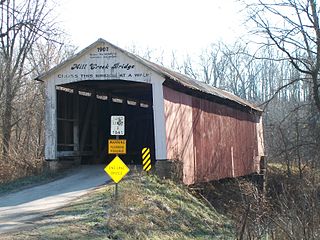
The Mill Creek Covered Bridge also known as "Thompson's Ford Covered Bridge," "Tow Path Covered Bridge," or "Earl Ray Covered Bridge" crosses Wabash Mill Creek (historic) southwest of Tangier, Indiana. It is a single span Burr Arch Truss covered bridge structure that was built by D. M. Brown in 1907.

<span class="mw-page-title-main">Narrows Covered Bridge</span> Place in Indiana listed on National Register of Historic Places

The Narrows Covered Bridge crosses Sugar Creek at the eastern edge of Turkey Run State Park and is a single span Burr Arch Truss covered bridge structure that was built by Joseph A. Britton in 1882.

<span class="mw-page-title-main">Portland Mills Covered Bridge</span> Bridge in Indiana, United States

The Portland Mills Covered Bridge is the second oldest covered bridge in Parke County, Indiana, being built the same year as the Crooks Covered Bridge. It is a single span Burr Arch Truss covered bridge that was built by Henry Wolf in 1856.

<span class="mw-page-title-main">Sanitorium Covered Bridge</span> Place in Indiana listed on National Register of Historic Places

The Sanitorium Covered Bridge is a bridged located east of Rockville, Indiana. The single-span Burr Arch covered bridge structure was built by Joseph A. Britton in 1913.

<span class="mw-page-title-main">Thorpe Ford Covered Bridge</span> Place in Indiana listed on National Register of Historic Places

The Thorpe Ford Covered Bridge is northeast of Rosedale, Indiana. The single span Burr Arch Truss covered bridge structure was built by Joseph A. Britton in 1912.

<span class="mw-page-title-main">West Union Covered Bridge (Indiana)</span> Place in Indiana listed on National Register of Historic Places

The West Union Covered Bridge formerly carried Tow Path Road over Sugar Creek north-northeast of Montezuma, Indiana. The two-span Burr Arch Truss covered bridge structure was built by Joseph J. Daniels in 1876. It is notable for being the longest standing covered bridge in Parke County, and one of the nation's best-preserved examples of the Burr truss.

<span class="mw-page-title-main">Wilkins Mill Covered Bridge</span> Place in Indiana listed on National Register of Historic Places

The Wilkins Mill Covered Bridge is north of Rockville, Indiana. The single span Burr Arch Truss covered bridge structure was built by William Hendricks in 1906. The bridge is 120 feet (37 m) long, 16 feet (4.9 m) wide, and 13 feet (4.0 m) high.

<span class="mw-page-title-main">Zacke Cox Covered Bridge</span> Place in Indiana listed on National Register of Historic Places

The Zacke Cox Covered Bridge is east of Mecca, Indiana. The single span Burr Arch Truss covered bridge structure was built by Joseph A. Britton in 1908.

Joseph Albert Britton (1839–1929), most commonly known as J.A. Britton, was a builder of bridges in Indiana. He created many works that survive and are listed on the U.S. National Register of Historic Places.

References

  1. "The Cox Ford Bridge". Indiana Covered Bridge Society. Retrieved 1 July 2021.
  2. "National Register Information System  Cox Ford Covered Bridge (#7) (#78000390)". National Register of Historic Places . National Park Service. January 23, 2007. Retrieved November 21, 2019.
  3. "Cox Ford Covered Bridge (#36)". coveredbridges.com. Parke County Incorporated / Parke County Convention and Visitors Commission. Retrieved 25 November 2019.
  4. "Indiana State Historic Architectural and Archaeological Research Database (SHAARD)" (Searchable database). Department of Natural Resources, Division of Historic Preservation and Archaeology. Retrieved 2016-06-01.Note: This includes Charles Felkner (December 1977). "National Register of Historic Places Inventory Nomination Form: Parke County Covered Bridge Historic District" (PDF). Retrieved 2016-06-01., Site map, and Accompanying photographs.
  5. "Cox Ford Covered Bridge". County History Preservation Society. Archived from the original on 20 October 2002. Retrieved 20 June 2016.